


NCERT Solutions for Class 7 Social Science Chapter 2 India and Her Neighbours
The Big Questions
Question 1: What defines a ‘neighbour’? Is it just shared land borders?
Answer:
A neighbour is commonly understood as a country that shares a direct boundary with another country. For example, India and Nepal are neighbours because they share a land border.
However, neighbouring countries do not always need to share land borders. Countries located close to one another across a sea or ocean are known as maritime neighbours. Sri Lanka and the Maldives are India’s maritime neighbours.
Therefore, a neighbour may be connected through a shared land border or geographical closeness across the sea. Neighbouring countries also influence one another through trade, migration, culture, travel, and diplomacy.
Question 2: How do geography and history influence the nature of India’s relationships with her neighbours?
Answer: Geography and history strongly shape India’s relationship with its neighbouring countries. India shares land borders with Pakistan, China, Nepal, Bhutan, Bangladesh, and Myanmar. It is also located close to maritime neighbours such as Sri Lanka and the Maldives.
Shared mountains, rivers, seas, and borders create opportunities for trade, travel, and cooperation. At the same time, they may lead to disagreements over boundaries and natural resources.
Historical connections, including the spread of Buddhism, Hindu traditions, languages, art, and trade, have brought India closer to its neighbours. However, events such as Partition, wars, and border disputes have also created tensions.
Thus, India’s relationship with its neighbours is shaped by geographical closeness, shared history, cultural links, cooperation, and occasional disagreements.
Question 3: In what ways are India and her neighbours interconnected today?
Answer: India and its neighbours are connected through trade, transport, culture, tourism, education, and shared traditions. People travel across borders for employment, healthcare, study, pilgrimage, and family visits.
These countries also share rivers, ecosystems, historical links, languages, festivals, and food habits. They cooperate in areas such as disaster relief, security, climate action, regional development, and peace.
Therefore, India and its neighbours are connected in many ways beyond their geographical boundaries.
Let’s Explore
Question 1: Identify the three large water bodies that surround India in the map below. (Page 30)
Answer:
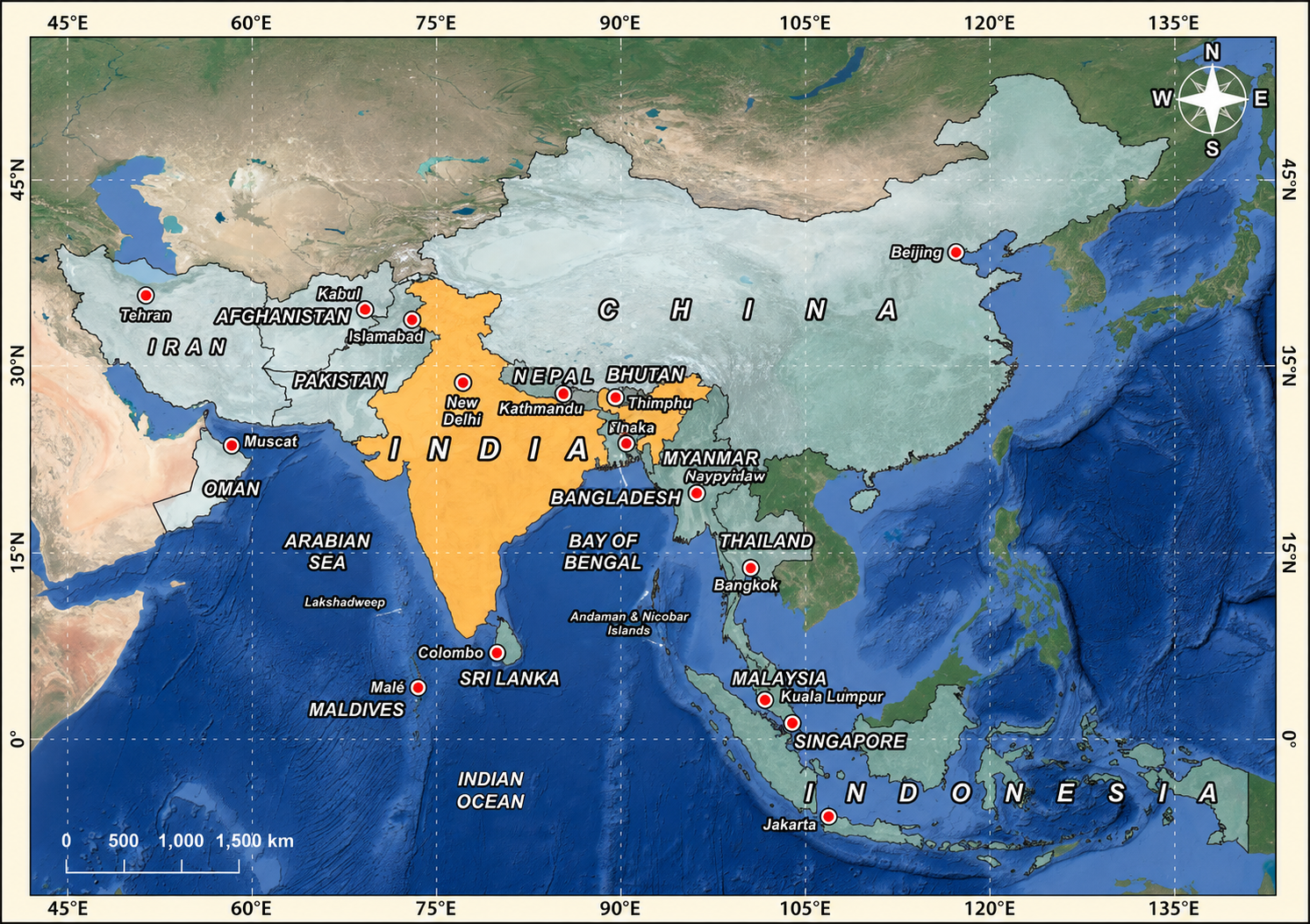
The three large water bodies surrounding India are:
Indian Ocean to the south
Arabian Sea to the west
Bay of Bengal to the east
Question 2: The scene in Fig. 2.21 depicts the well-known Hindu myth of samudra manthana or the churning of the ocean. The devas (gods, on the right here) and the asuras (demons, on the left) decided to join forces to churn the cosmic ocean in search of amrita or the nectar of immortality, with the serpent Vasuki as the churning rope and Vişhnu (above) presiding over the operation – he will eventually deceive the asuras to make sure that the amrita goes to the devas alone. Note also the airport’s official name of ‘Suvarnabhumi Airport’ – does it remind you of something? (Page 51)
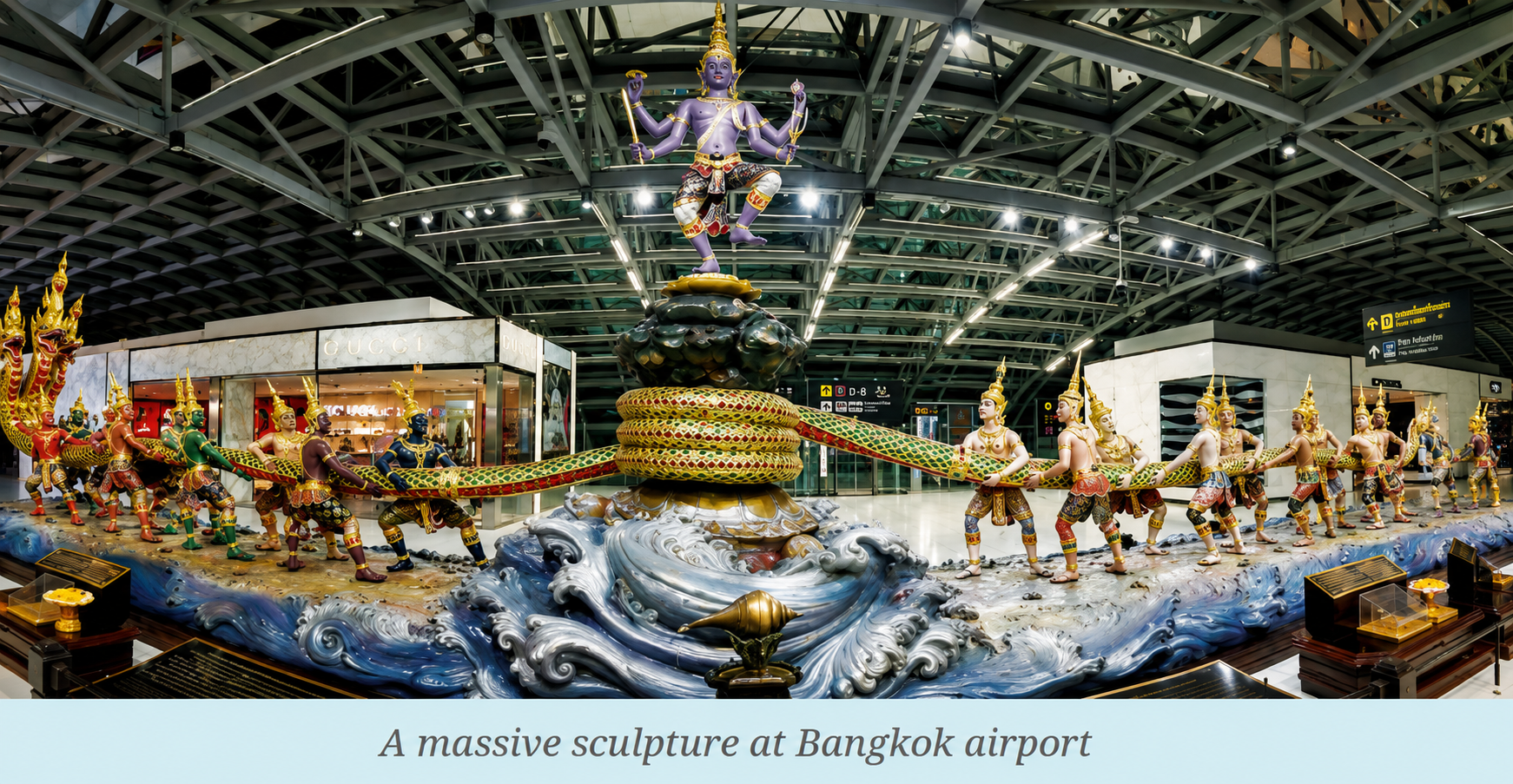
Answer:
Yes, the name ‘Suvarnabhumi Airport’ reminds us of the ancient term Suvarnabhumi, meaning the “land of gold”.
Indian traders travelled to regions such as Java, Sumatra, and the Malay Peninsula in search of gold, spices, and other valuable goods. These regions became known as Suvarnabhumi or Suvarnadvipa, meaning the “golden land” or “golden island”.
The name reflects the long-standing cultural and commercial relationship between India and Southeast Asia.
Question 3: Seeing that Tamil is one of Singapore’s official languages, what does this suggest to you about the relationship between south India and Singapore? (Page 53)
Answer: Tamil, being one of Singapore’s official languages, shows the deep historical and cultural relationship between South India and Singapore.
Tamil-speaking traders, workers, and families migrated to Singapore over many centuries. Trade routes also connected South India with Southeast Asia. These movements helped spread Indian languages, food, customs, religious traditions, and cultural practices.
It shows that South India and Singapore share strong cultural, linguistic, and commercial ties.
Don’t Miss Out
Question 1: Can the Kartarpur Corridor be a model for the possible progress of peace and dialogue? (Pages 36)
Answer: Yes, the Kartarpur Corridor can be viewed as a meaningful example of cooperation and dialogue between India and Pakistan.
It allows Sikh pilgrims from India to visit the Gurudwara Darbar Sahib in Pakistan without obtaining a regular visa. This shows how shared religion, culture, and respect can create cooperation despite political differences.
Although several larger issues remain unresolved, the corridor demonstrates that working together on matters of common interest can build trust and support peaceful dialogue.
India and Her Neighbours Class 7 Solutions (Exercise)
Question 1: Explain who a maritime neighbour is with two examples with respect to India.
Answer:
A maritime neighbour is a country located close to another country across a sea or ocean. The countries may share a maritime boundary even if they do not share a land border.
Two examples of India’s maritime neighbours are Sri Lanka and Thailand.
Sri Lanka lies to the southeast of India and is separated from it by the Palk Strait. At its closest point, Sri Lanka is only about 32 kilometres from India.
Thailand lies to the east of India across the Bay of Bengal and the Andaman Sea. India and Thailand share a maritime boundary and are also connected through regional transport and trade routes.
Question 2: How has Buddhism created links with India’s neighbours? Give examples to explain your answer.
Answer:
Buddhism created strong cultural and spiritual connections between India and its neighbouring countries. Buddhist teachings, art, literature, monasteries, and traditions travelled from India to different parts of Asia.
Nepal is closely connected with Buddhism because Lumbini, the birthplace of Gautama Buddha, is located there. Buddhism reached Sri Lanka during the reign of Emperor Ashoka and later became an important part of Sri Lankan culture.
Bhutan and Tibet also developed close links with India through Buddhist teachers, scholars, texts, and monasteries. Buddhist ideas travelled to Myanmar through trade routes, monks, and pilgrims.
Thus, Buddhism acted as a cultural bridge that connected India with Nepal, Sri Lanka, Bhutan, Myanmar, Tibet, China, and other Asian regions.
Question 3: What does ‘open border’ policy mean? How does the India-Nepal ‘open border’ policy affect the lives of people living along the border?
Answer:
An open border policy allows people from neighbouring countries to cross the border without regularly requiring a passport or visa.
The India-Nepal open border is supported by the Treaty of Peace and Friendship signed in 1950. It allows the easy movement of people between the two countries.
This policy helps people living near the border travel for employment, education, healthcare, business, festivals, and family visits. Families from both sides also maintain social and marriage relationships.
However, an open border can sometimes be misused for illegal activities. Therefore, the governments of India and Nepal cooperate to keep the border safe while allowing people to move freely.
Question 4: The chapter says, “Being neighbours is not just about geography.” Explain this statement with an example.
Answer: The statement means that neighbouring relationships are not based only on shared borders. They are also shaped by history, culture, religion, trade, language, and people-to-people connections.
India and China provide a suitable example. Buddhism travelled from India to China many centuries ago. Chinese scholars visited Indian centres of learning, while Indian monks carried Buddhist teachings and texts to China.
The two countries were also connected through the Silk Route and ancient trade networks. Although India and China have disagreements over their shared border, they continue to maintain trade and diplomatic relations.
This shows that neighbouring countries can remain connected through cultural and economic relationships even when political differences exist.
Question 5: What are the different ways in which India has helped smaller countries in her neighbourhood? Explain with examples.
Answer: India has supported smaller neighbouring countries through development projects, disaster relief, healthcare, education, infrastructure, and cultural restoration.
(i) Myanmar: India helped restore the Ananda Temple in Bagan after it was damaged by an earthquake. India also gifted Myanmar a 16-foot replica of the Buddha statue from Sarnath.
(ii) Afghanistan: India supported projects related to education, healthcare, roads, and infrastructure. It also helped construct the Afghan Parliament building and the Zaranj-Delaram Highway.
(iii) Maldives: India provided immediate assistance after the 2004 tsunami, during the 2014 drinking-water crisis in Malé, and during the COVID-19 pandemic.
These efforts have strengthened India’s social, cultural, economic, and diplomatic relationships with its neighbours.
Question 6: How do shared challenges become opportunities for cooperation? Were there examples in this chapter to illustrate this?
Answer: Shared challenges encourage neighbouring countries to work together because many problems cannot be solved by one country alone.
Challenges such as terrorism, border security, climate change, natural disasters, piracy, environmental damage, and economic inequality create opportunities for cooperation.
Examples from the chapter include:
India and China use dialogue, trade, and border-management mechanisms to address disagreements.
The Kartarpur Corridor allows Sikh pilgrims from India to visit an important religious site in Pakistan.
India and Bangladesh cooperate to protect the Sundarbans ecosystem.
India and Myanmar work together to support the movement of people living in border areas.
India and Indonesia cooperate in maritime security, defence, disaster relief, protection of sea routes, and action against piracy.
Therefore, common problems can help countries develop stronger partnerships and find shared solutions.
Question 7: If borders were drawn only by culture and connections, how would the map look different?
Answer: If borders were drawn only according to culture and human connections, the map would look like a complex mosaic rather than a political map with clearly defined boundaries.
Regions might be grouped according to shared languages, religions, food habits, festivals, historical links, or ethnic identities. Some cultural areas would overlap across present-day national borders.
Creating such borders would be difficult because people in the same region may have several different identities and cultural connections. It could also create confusion and disagreements.
Therefore, a culture-based map would look very different and would be much more complicated than the present political map.
Question 8: On blank maps:
(a) Label India’s neighbours.
(b) Draw arrows showing cultural flows (e.g, food, festivals, languages) between India and her neighbours.
(c) Imagine and redraw new “borders of friendship” that connect neighbours through rivers, trade routes, or cultural zones.
(d) Collect pictures of the flags of the countries listed in this chapter and write your observations.
Answer: (a)
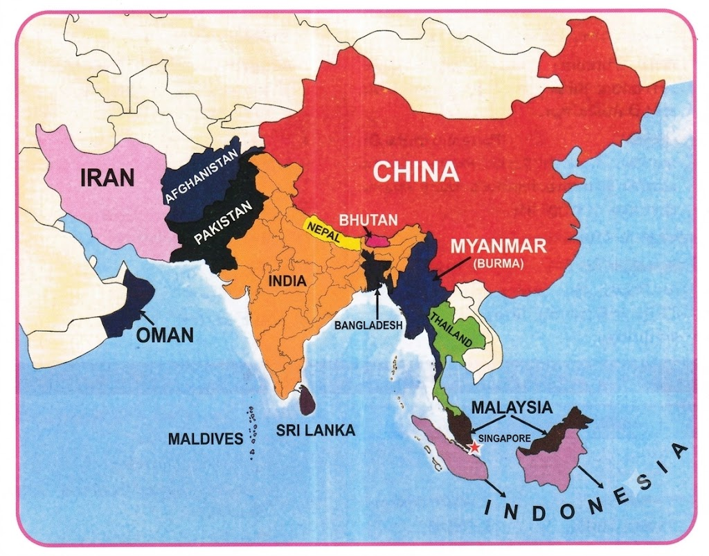
Students can label Pakistan, Afghanistan, China, Nepal, Bhutan, Bangladesh, Myanmar, Sri Lanka, and the Maldives on a blank map.
(b) Students can draw arrows to represent the following cultural exchanges:
Food Exchanges
India-Nepal: Dal-bhat, momos, turmeric, cumin, and other shared spices
India-Bangladesh: Fish curries, rice dishes, rasgulla, and sandesh
India-Pakistan: Biryani, kebabs, parathas, Punjabi food, and Mughlai dishes
India-Sri Lanka: Rice-based meals, coconut curries, hoppers, and dosas
India-Myanmar: Curries, lentils, and Indian-influenced street food
India-Afghanistan: Naan, kebabs, dried fruits, and pulao
Festival Connections
Diwali: Celebrated in India, Nepal, and Hindu communities in nearby countries
Eid: Celebrated in India, Pakistan, Bangladesh, and Afghanistan
Buddha Purnima: Observed in India, Nepal, Bhutan, Sri Lanka, and Myanmar
Durga Puja: Celebrated widely in India and Bangladesh
Holi: Popular in India and Nepal and among communities in nearby countries
Harvest festivals: Pongal, Baisakhi, and similar festivals reflect common agricultural traditions
Language and Literature Connections
Sanskrit and Pali: Influenced religious and literary traditions in Nepal, Sri Lanka, Myanmar, and Tibet
Hindi and Urdu: Connect India and Pakistan through films, poetry, music, and everyday speech
Bengali: Shared by communities in India and Bangladesh
Tamil: Spoken in India, Sri Lanka, Singapore, and other Southeast Asian regions
Punjabi: Shared across India and Pakistan through songs, poetry, and folklore
(c) Students can create their own “borders of friendship” by connecting countries through shared rivers, trade routes, languages, religions, food traditions, or festivals.
(d) Students can collect the flags, compare their colours, symbols, shapes, and designs, and write their own observations.
Let’s Explore
Question 1:
(a) Create a list of the foods you typically eat.
(b) Identify the grains, pulses, oils, vegetables, and fruits in them.
(c) Now locate where you live on a physical map of India. (You may refer to the political map of India at the end of the book if you wish.)
(d) Which of the food items do you think grow in and around where you live?
(e) What do you think are the reasons that they are cultivated in your region?
(f) Which of them comes from other places?
(g) Why do you think they are not grown in your area?
Answer:
Suggested answer:
(a) Foods that I usually eat include roti, rice, dal, idli, poha, vegetables, curd, fruits, chana, and eggs.
For breakfast, I may eat roti, poha, idlis, or eggs. Lunch usually includes rice, dal, vegetables, and curd. I may eat fruits, chana, or biscuits as snacks. Dinner generally includes rice or roti with vegetables and pulses.
(b) Agricultural products used in these foods
Grains:
Rice
Wheat
Poha, made from flattened rice
Rice used to prepare idlis
Pulses:
Arhar dal
Moong dal
Chana
Urad dal used in idli batter
Oils:
Mustard oil
Sunflower oil
Soybean oil
Vegetables:
Potato
Tomato
Beans
Brinjal
Lady’s finger
Spinach
Cauliflower
Fruits:
Banana
Apple
Mango
Guava
(c) I live in Muzaffarpur, located in north-central Bihar.
(d) Rice, wheat, maize, chickpea, pigeon pea, and some millets grow in and around my region. Fruits such as litchi, mango, banana, and guava are also commonly cultivated.
(e) These crops grow well because the region has fertile alluvial soil, suitable temperatures, monsoon rainfall, and access to rivers, ponds, and groundwater.
(f) Apples, sunflower oil, soybean oil, and some varieties of rice used for idli and dosas may come from other regions.
(g) These products are not widely grown locally because they require different climatic or soil conditions. Apples need a cold climate, while sunflowers and soybeans generally grow better in comparatively drier regions.
Question 2: Imagine that your state received less than normal monsoon rains for two consecutive years. Which items are likely to disappear from your meals, or are likely to become difficult to access?
Answer:
If the state receives less than normal monsoon rainfall for two consecutive years, many crops may be affected because they depend on rain and adequate soil moisture.
Rice may become scarce because it requires a large amount of water. Wheat may also be affected if low rainfall reduces groundwater and irrigation availability.
Pulses such as arhar, moong, and urad may become more expensive. Green vegetables such as spinach, cauliflower, cabbage, and beans may be available in smaller quantities because they need regular watering.
Fruits such as bananas and papayas may also be affected. Sugarcane production may decrease because it is a water-intensive crop, which could increase sugar prices.
Therefore, prolonged low rainfall may reduce food production, increase prices, and make several everyday food items difficult to access.
Question 3: Prepare a list of the crops that are cultivated in your state or union territory in a year and classify them into kharif, rabi, and zaid.
Answer: Crops cultivated in my area can be classified as follows:
Kharif Crops
Grown mainly during the monsoon season from June to October.
Cereals: Rice, maize, jowar, and bajra
Pulses: Arhar, moong, and urad
Oilseeds: Groundnut, soybean, sesame, and castor
Vegetables: Brinjal, tomato, okra, and pumpkin
Rabi Crops
Grown mainly during the winter season from November to April.
Cereals: Wheat, barley, and oats
Pulses: Gram, masoor, and peas
Oilseeds: Mustard, linseed, and sunflower
Vegetables: Cauliflower, cabbage, carrot, and spinach
Zaid Crops
Grown mainly during the summer season from March to June.
Cereals: Summer maize
Pulses: Summer moong
Oilseeds: Summer sunflower and sesame
Vegetables and fruits: Cucumber, watermelon, muskmelon, and bitter gourd
Question 4: Try to name at least two states in each of the zones mentioned above.
Answer:
Two states from each agroclimatic zone are:
Upper Gangetic Plain Region: Uttar Pradesh and Bihar
Southern Plateau Region: Maharashtra and Karnataka
Hill Region: Himachal Pradesh and Uttarakhand
Western Dry Region: Rajasthan and Gujarat
These regions have different climates, soils, rainfall patterns, and landforms. Therefore, they support different crops and farming practices.
Question 5: Which type of soil is predominantly found in your state or union territory?
Answer:
Alluvial soil is predominantly found in Bihar.
Bihar lies in the Gangetic Plain, where rivers deposit silt, sand, clay, and other fine materials. These deposits form fertile alluvial soil.
This soil is rich in nutrients and supports crops such as rice, wheat, maize, pulses, sugarcane, fruits, and vegetables. Therefore, alluvial soil plays an important role in Bihar’s agriculture.
Question 6: Soils tell us stories about places – what might have happened over thousands of years during which the soils were being formed. Take a few samples of soil from your neighbourhood. Look carefully at them. (Examine the soil using a magnifying glass or microscope if you have access to either.) What do the samples consist of? What might be the origins of the soil? Are there signs of human activity that you notice? What might happen to the soil over time on account of this?
Answer: After observing soil samples from my neighbourhood, I found small grains of sand, fine silt, clay particles, pebbles, dry leaves, roots, and decomposed organic matter.
The soil may have been formed through the weathering of rocks and the deposition of materials carried by rivers. Dead plants and animals also decompose over time and add organic matter to the soil.
Pieces of plastic, bricks, and other waste materials may indicate human activity. Excessive chemical fertilisers, plastic waste, construction, and the cutting of trees may gradually pollute the soil, reduce its fertility, and increase erosion.
Using compost, planting trees, reducing plastic waste, and limiting harmful chemicals can help protect the soil.
Question 7: Take up a small group project. Identify the types of vegetables, fruits, and trees that grow in the different soil types.
Answer: Students can complete this project by collecting information about crops and plants grown in different soils.
Alluvial soil: Potato, tomato, onion, brinjal, banana, guava, papaya, and mango
Black soil: Cotton, soybean, chillies, and grapes
Red soil: Maize, groundnut, millets, pulses, pomegranate, and custard apple
Laterite soil: Cashew, coconut, rubber, tea, coffee, and pineapple
Alpine soil: Apple, strawberry, almond, walnut, and pine
Sandy soil: Carrot, cucumber, watermelon, date palm, and desert plants
This activity shows that soil type strongly influences the crops and plants grown in a region.
Question 8: Create a family food flowchart that connects your favourite dishes to the different crops they are prepared from and the corresponding soil types in which they are cultivated.
Answer: Students can create their own flowchart by connecting each favourite dish with its main crop ingredients and the soil types in which those crops are commonly grown.
Example:
Roti → Wheat → Alluvial soil
Rice and dal → Rice and pulses → Alluvial soil
Idli → Rice and urad dal → Alluvial and red soil
Groundnut chutney → Groundnut → Red soil
Fruit salad → Mango, banana, and guava → Alluvial soil
Question 9: Identify modern agricultural solutions inspired by traditional practices (for example, neem-based practices).
Answer: Several modern agricultural methods are based on traditional farming knowledge.
Neem-based pesticides: Neem leaves and extracts were traditionally used to repel insects. Today, neem-based biopesticides control pests while reducing the use of harmful chemicals.
Organic manure and compost: Farmers have long used cow dung, dry leaves, and plant waste to improve soil fertility. These materials are now widely used in organic farming.
Crop rotation: Growing different crops in different seasons helps maintain soil nutrients and reduce pests.
Mixed cropping and intercropping: Growing more than one crop in a field reduces the risk of complete crop failure and makes better use of the soil.
Rainwater harvesting: Traditional ponds, tanks, and stepwells have inspired modern farm ponds, recharge pits, and check dams.
Mulching: Covering soil with straw and leaves helps retain moisture. Modern farming uses both organic mulch and specialised sheets for the same purpose.
These examples show how traditional knowledge can be combined with scientific methods to make agriculture more sustainable.
Question 10: Listen to the special programmes for farmers on the radio or watch a programme on television for a few days. Write down carefully the information that is shared through these mediums. Make a short report on the categories of information you gathered as well as questions that came to your mind during this activity.
Answer: I watched Krishi Darshan and other farming-related television programmes for a few days. The programmes shared information under the following categories:
Weather and climate: Daily and weekly forecasts, rainfall, drought, storms, and heatwave warnings were provided to help farmers plan sowing, irrigation, and harvesting.
Crop guidance: The programmes explained suitable sowing times, soil preparation, crop care, pest management, and methods of improving crop yield.
Modern farming methods: Information was given about drip irrigation, sprinkler systems, improved seeds, organic farming, fertilisers, and soil testing.
Government support: The programmes discussed subsidies, crop insurance, agricultural loans, and support for purchasing seeds and machinery.
Market prices: Farmers received information about current crop prices and markets where they could sell their produce.
Success stories: The programmes featured farmers who improved production by using new techniques.
Some questions that came to my mind were how small farmers can afford modern equipment and how weather forecasts can be made more accessible in local languages.
Don’t Miss Out
Question 1: The Arthashastra contains sections on agriculture, including the preparation of land and seeds, as well as payment to farmers and other relevant topics. “A good rainy season is one when one-third of the annual rainfall occurs at the beginning (Shravaa – July-August) and at the end of the season (Kartika – OctoberNovember), and two-thirds in the middle (Prauşhţhapada – August-September and Ashvayuja – September-October).” Why do you think this statement was made? (Hint: Did it have anything to do with the crop cycle?)
Answer:
The statement was made because both the amount and timing of rainfall are important for the crop cycle.
Rainfall at the beginning of the season softens the soil and prepares it for ploughing and sowing. It also provides enough moisture for seeds to germinate.
Heavier rainfall in the middle of the season supports the main growth stage of crops, when plants need the most water.
Rainfall near the end of the season helps crops complete their growth and mature. However, excessive rain during harvesting can damage mature crops.
Therefore, ancient agricultural thinkers understood that a good rainy season depended not only on the total rainfall but also on its proper distribution across different stages of crop growth.
Class 7 Social Science Chapter 2 India and Her Neighbours Solutions
Vedantu provides NCERT Solutions for Class 7 Social Science Chapter 2 India and Her Neighbours from Exploring Society India and Beyond Part 2 for the 2026-27 academic session. The chapter explains how geography, history, culture, trade, religion, and shared challenges influence India’s relationship with neighbouring countries.
The solutions provide clear answers to textbook exercises, map activities, and discussion-based questions. Students can use them for homework, classroom learning, quick revision, and exam preparation. The downloadable FREE PDF also helps learners revise the complete chapter anytime.
CBSE Class 7 Social Science Chapter 2 Study Materials
Students can use the following Chapter 2 study materials to revise important topics, practise additional questions, and strengthen their understanding of India’s relations with its neighbours.
Explore More NCERT Solutions for Class 7 Social Science Chapters
Related Study Material for Class 7 Social Science
FAQs on NCERT Solutions for Class 7 Social Science Chapter 2 India and Her Neighbours – Exploring Society India and Beyond Part 2 (2026-27)
1. What is covered in Class 7 Social Science Chapter 2 India and Her Neighbours?
The chapter explains India’s land and maritime neighbours, shared geographical features, cultural connections, historical relations, trade links, and examples of cooperation between neighbouring countries.
2. Which book contains Class 7 Social Science Chapter 2 India and Her Neighbours?
India and Her Neighbours is Chapter 2 of the Class 7 NCERT Social Science textbook, Exploring Society India and Beyond Part 2.
3. Who are India’s land neighbours?
India shares land borders with Pakistan, Afghanistan, China, Nepal, Bhutan, Bangladesh, and Myanmar.
4. What is a maritime neighbour?
A maritime neighbour is a country located close to another country across a sea or ocean. Sri Lanka and the Maldives are important maritime neighbours of India.
5. Why is geography important in India’s relations with her neighbours?
Shared borders, rivers, mountains, seas, and natural resources influence trade, transport, security, migration, and cooperation between India and neighbouring countries.
6. How has Buddhism connected India with neighbouring countries?
Buddhism spread from India to Nepal, Sri Lanka, Bhutan, Myanmar, Tibet, China, and Southeast Asia. Buddhist monks, scholars, art, literature, and pilgrimage routes created lasting cultural connections.
7. What is the India-Nepal open border policy?
The open border policy allows citizens of India and Nepal to cross the border without regularly requiring a passport or visa. It supports travel, employment, healthcare, education, trade, and family relationships.
8. How does India help smaller neighbouring countries?
India supports neighbouring countries through disaster relief, healthcare, education, infrastructure projects, cultural restoration, development assistance, and emergency supplies.
9. How do NCERT Solutions for Chapter 2 help students?
The solutions provide clear answers to textbook questions, exercises, map activities, and discussion-based tasks. They help students complete homework, revise the chapter, and prepare for examinations.
10. Where can students download Class 7 Social Science Chapter 2 solutions?
Students can download the FREE PDF of NCERT Solutions for Class 7 Social Science Chapter 2 India and Her Neighbours from Vedantu for easy learning and revision.