-
 Courses
-
Long term Courses for Class 3-13
-
Crash Courses
-
JEE Courses for Class 11,12,13
-
NEET Courses for Class 11,12,13
-
CBSE Interactive Books for Class 6-10
-
Distance Learning for Class 11,12,13
-
Class 13
-
Class 12
-
Class 11
-
-
CUET Courses
-
Vedantu Super Kids
-
-
 Reading & Spoken English
 -
FREEMaster Classes
-
PREMIUM1-on-1 Classes
-
Study Material
-
NCERT Solutions
-
Previous Year Papers
-
Mock Tests
-
Sample Papers
-
Reference Book Solutions
-
ICSE Solutions
-
School Syllabus
-
Revision Notes
-
Important Questions
-
Math Formula Sheets
-
-
More


Book your FREE Online counselling session
Share the following information

Your FREE Online counselling session has been booked!
Vedantu academic counsellor will be calling you shortly for your Online Counselling session.
Please try again later
Globe Latitudes and Longitudes Class 6 Social Science Geography Chapter 2 CBSE Notes - 2025-26

Social Science Geography Notes for Chapter 2 Globe Latitudes and Longitudes Class 6 - FREE PDF Download


 Download PDF
Access Class 6 Social Science (Geography) Chapter 02 - Globe Latitudes and Longitudes Notes
1. The globe that we see is a representation of the earth. The needle passes through the balloon in an oblique manner, called its axis.
2. An imaginary line passing through the earth divides the earth into equal parts. This line is called Equator.
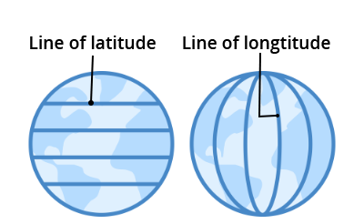
3. All the parallel circles from the equator to the poles are known as latitudes. Latitude is also measured in degrees.
4. When we move away from the equator, the size of the line of latitude decreases. The four important parallel lines of latitude are:
a. Tropic of Cancer (23.5°N of equator)
b. Tropic of Capricorn (23.5 °S of equator)
c. Arctic Circle (66.3°N)
d. Antarctic Circle (66.3°S)
6. Hot Zone of the Earth i.e. Torrid Zone Receives Maximum heat.
7. The temperature is found moderate in temperate regions. For example: China, America, Northern India etc.
8. The climate in the frigid zone is cold because the sun's rays are always inclined.
Longitude
i. The reference line from North Pole to South Pole is called the longitude meridian.
ii. The distance between them is measured by "Degree of longitude".
iii. All meridians have the same longitude.
iv. The meridian which passes through Greenwich, also where the Royal Observatory is located, is called the prime meridian.
v. The value of the prime meridian is 0° longitude, from which we calculate east longitude 180° and west longitude 180°.
vi. The prime meridian is responsible for dividing the earth into two equal parts, the eastern hemisphere and the western hemisphere.
vii. Lines of 180 ° east longitude and 180 ° west longitude are on the same line.
viii. If we know the latitude and longitude of the earth, we can locate any point on the earth.
Longitude and Time
i. As the Earth rotates from west to east, places located in the east of Greenwich will lead to Greenwich, and places located in the west will lag behind Greenwich.
ii. The Earth rotates 360 ° in approximately 24 hours.
iii. In any place, when the sun is highest in the sky, the watch can be set at 12 o'clock.
iv. Standard Time :- The local time varies from place to place, so it is necessary to use the local time of a certain central meridian in a certain country as the standard time.
v. 82.5°E is regarded as the standard meridian of India. The local time on this meridian is called Indian Standard Time (IST).
vi India, located at 82°30`E east of Greenwich, 5 hours and 30 minutes earlier than Greenwich Mean Time.
vii. Some countries have a large vertical extension, which is why they use more than one standard time.
viii. The Globe is a real model of the earth, with a small appearance. A needle called a shaft passes through the balloon at an angle.
ix. The axis of the earth passes through two extreme points: called the poles (North Pole and South Pole). This axis is shown in the shape of a needle on the earth.
x. The circle that passes through the center of the Earth and is perpendicular to the axis of the Earth is called the equator. It divides the earth into two hemispheres, the northern hemisphere and the southern hemisphere. We can imagine more circles parallel to the equator, with their centers on the axis and with different radii. These circles are referred to as lines of latitude.
xi. Parallel lines are determined by degrees. The equator represents zero degrees of latitude. The latitude of the northern hemisphere is designated as north (° N), p. For example, 10°N, 20°N, and so on until 90°N (this is the North Pole). Similarly, the latitude of the southern hemisphere is designated south latitude (°S), and 90°S is the South Pole.
xii. The circle passing through Greenwich, England, perpendicular to the equator and parallel to the axis, is called the prime meridian. The prime meridian is responsible for dividing the earth into two hemispheres, one the eastern hemisphere and the other western hemisphere. The equator and the prime meridian divides the earth into four equal parts. Imagine more circles parallel to the prime meridian, with their centers at the center of the earth and equal radii. These circles are known as longitudes.
xiii. The length is determined with the help of degrees. The prime meridian represents degrees zero longitude. The longitude of the eastern hemisphere is designated as the east longitude (° E), p. For example, 10°E, 20°E, and so on until 180°. The situation in the Western Hemisphere is similar. Degrees are divided into minutes, and minutes are divided into seconds. Note that the symbol for one minute is an apostrophe (`), and the second is a double apostrophe ("). 60 feet (60 minutes) constitute one degree and 60 inches (60 seconds) constitute one minute. So 30` means half a degree and 40 "means two thirds of a minute.
xiv. Two points on earth can be at the same latitude, but still far apart. Also, two distant points can be the same longitude. But only one point is on a specific latitude and longitude pair. So latitude and longitude help locate a point on the earth.
xv. The Tropic of Cancer and the Arctic Circle are special latitudes present in the northern hemisphere. They are located at 23 1/2 ° N and 6612 ° N, respectively.
xvi. The Tropic of Capricorn and the Antarctic Circle are special latitudes present in the southern hemisphere. They are located at 23 12 ° S and 66 12 ° S, respectively.
xvii. The area between the Tropic of Cancer and the Tropic of Capricorn receives the most heat from the Sun. This area is referred to as the hot zone.
xviii. The temperature is moderate in the areas between the Aarti Circle and the Tropic of Capricorn in the Northern Hemisphere, and between the Antarctic Circle and the Tropic of Capricorn. These regions are temperate regions.
What is Latitude?
The latitude is a proper measurement on the map or a proper globe of any location which is North or the South of the Equator. The latitude can be measured with the help of a line which is imaginary and is known as the Prime Meridian. The latitude can be measured in any particular angle that ranges between 0° at the Equator to 90° at the poles Find more details about latitude in globe latitudes and longitudes Class 6 notes.
What is Longitude?
The longitude can be defined as the measurement of any particular location which is a situation to the east or the west of the Prime Meridian, that too, at Greenwich. Students will easily be able to understand these topics with the Globe latitudes and longitudes Class 6 PPT.
An Overview of Globes, Longitude, and Latitude
Globes can be of different sizes and there are many types too. You have the small globes that fit in a pocket and then there are larger ones. One of the main things about the globe is that it can easily be rotated as there is no fixed point to it. There are countries, oceans, and continents shown in the globe and their right size as well. The globe has a needle fixed through it in a titled fashion that we know is the axis.
The two extreme points through which this needle will pass is known as the two different poles, North and South. Another important line passes through the globe and it divides it into two different parts, the Northern and the Southern Hemisphere. This particular line is known as the equator. According to the NCERT Geography Class 6 Chapter 2 notes, the equator is basically just the imaginary line which is circular and can be used for locating different places on the globe. Every single one of the circles that run parallel to the equator can be called the parallels of latitudes. These are measured properly in degrees.
The equator is a representation of the zero degrees latitude. We all know that the distance of poles from the equator is about 1/4th of the entire circle of the earth. Hence, the degree measured would also be one-fourth of the entire rotation which is three hundred sixty degrees, also 90°. So, about 90 degrees to the North latitude will denote the North Pole and 90 degrees to the South would denote the South pole. Students can refer to the Class 6 Geography Chapter 2 notes for more information.
The Parallels of Latitude
There are four different and very important parallels of latitudes that students need to know about. It is all described in the chapter Globe Latitudes and longitudes Class 6 notes.
1. Tropic of Cancer (23½° N) is located in the Northern Hemisphere.
2. Tropic of Capricorn (23½° S) which is located in the Southern Hemisphere.
3. The Arctic Circle is situated at 66½° north of the equator.
4. The Antarctic Circle is situated at 66½° south of the equator.
Different Heat Zones Located In the Earth
There are different types of heat zones that are located on Earth. Students can know about it with the Globe Latitudes and longitudes Class 6 PPT.
1. Torrid Zones: The Torrid Zone is the area which gets maximum heat since the sun at its Mid-day is right over the head and that too at least once every single year. This happens on all the latitudes which are situated between the Tropic of Capricorn and Tropic of Cancer.
2. Temperate Zones: The Temperate Zone has some sort of moderate temperature. This happens when the sun in the midday doesn’t shine overhead on any specific latitude which is situated beyond the Tropic of Cancer as well as the Tropic of Capricorn. So, the areas which are bounded by these parallel latitudes in the Northern and the Southern Hemisphere tend to have some moderate type of climate.
3. Frigid Zones: Now these are the zones or areas that lie between the North Pole and the Arctic Circle which is present in the Northern Hemisphere and the South Pole and the Antarctic Circle which is present in the Southern Hemisphere. The reason for these zones being frigid is that the sun doesn’t rise much and that too above the horizon in these regions. So, the rays of the sun in these areas tend to always be in a slanting position. The heat produced is much lesser and these areas tend to be a lot colder than expected.
Importance of CBSE Class 6 Geography Chapter 2 Globe Latitudes and Longitudes
CBSE Class 6 Geography Chapter 2 - Globe Latitudes and Longitudes holds significant importance in a student's academic journey and overall understanding of the Earth's geography. This chapter introduces students to the concept of latitudes and longitudes, which are crucial tools used in navigation, cartography, and understanding the Earth's climate and time zones.
Understanding latitudinal and longitudinal lines helps students locate places accurately on the globe, enabling them to interpret maps and globes with ease. It fosters spatial awareness, which is essential in various fields, including geography, astronomy, and travel.
Additionally, comprehending latitudes and longitudes lays the foundation for learning about the diverse cultures, climates, and ecosystems across the globe. It helps students appreciate the Earth's diversity and interconnectedness, promoting a sense of global citizenship and environmental consciousness.
Moreover, this knowledge becomes invaluable for aspiring explorers, travelers, and scientists, as it facilitates accurate data collection, research, and analysis. It empowers students to better comprehend global phenomena like climate change and natural disasters, thereby encouraging proactive solutions to these global challenges.
Benefits of Vedantu’s Revision Notes
Concise and well-organized: Vedantu's revision notes present information in a clear and succinct manner, making it easy for students to review key concepts quickly.
Comprehensive coverage: The notes encompass all the essential topics, ensuring students have access to all relevant information for exam preparation.
Visual aids: The inclusion of diagrams, charts, and illustrations enhances understanding and retention of complex concepts.
Easy accessibility: Vedantu's revision notes are readily available online, allowing students to access them anytime and from anywhere.
Time-saving: With these notes, students can save time by focusing on important topics, eliminating the need to sift through extensive textbooks.
Exam-oriented: The notes are designed to align with the exam syllabus, helping students stay focused on the most relevant content.
Quick revision: The concise format allows for efficient last-minute revision before exams, boosting confidence and performance.
Supplementary support: The notes complement Vedantu's other study materials, providing comprehensive support for a holistic learning experience.
Interactive learning: Vedantu's revision notes are often integrated with multimedia elements, making learning engaging and interactive.
Enhanced retention: The notes use simple language and mnemonic aids to aid memory retention, facilitating better recall during exams.
Conclusion
Vedantu's Globe Latitudes and Longitudes Class 6 Notes offer an invaluable resource for CBSE Geography Chapter 2. With a comprehensive and easily accessible Free PDF Download, students can grasp the fundamental concepts of latitudes and longitudes effortlessly. The notes provide clear explanations, vivid illustrations, and practical examples, enhancing students' understanding of how these geographical coordinates function on the globe. Vedantu's commitment to quality education shines through, as the notes cater to the needs of Class 6 students, ensuring a strong foundation in geography. Embracing these notes empowers learners to navigate the world of latitudes and longitudes with confidence and curiosity, fostering a deep appreciation for the Earth's complexities.
1. What is the main concept of a globe as explained in Class 6 Geography Chapter 2?
A globe is a true, miniature 3D model of the Earth. For revision, remember it's the only way to see the correct shape, size, and location of continents and oceans without distortion, unlike a flat map. It can be rotated on its axis, which is the imaginary line it spins around.
2. How can I quickly summarise the difference between latitudes and longitudes for revision?
For a quick summary:
- Latitudes are imaginary horizontal circles that run from east to west. They measure distance north or south of the Equator (0°).
- Longitudes are imaginary semi-circles that run from the North Pole to the South Pole. They measure distance east or west of the Prime Meridian (0°).
3. What are the most important parallels of latitude to remember from this chapter?
Besides the Equator (0°), you should remember four key parallels for your revision notes:
- The Tropic of Cancer (23.5° N) in the Northern Hemisphere.
- The Tropic of Capricorn (23.5° S) in the Southern Hemisphere.
- The Arctic Circle (66.5° N), north of the Equator.
- The Antarctic Circle (66.5° S), south of the Equator.
4. How do the parallels of latitude help in understanding the Earth's Heat Zones?
The key parallels of latitude act as boundaries for the Earth's three main heat zones, a core concept for revision.
- The Torrid Zone, receiving the most direct sunlight, lies between the Tropic of Cancer and the Tropic of Capricorn.
- The Temperate Zones, with moderate temperatures, are found between the Tropics and the Arctic/Antarctic Circles.
- The Frigid Zones, which are very cold, lie beyond the Arctic and Antarctic Circles.
5. What is the core concept of the Prime Meridian and its significance?
The Prime Meridian is the longitude designated as 0°. Its main purpose is to serve as the starting point for measuring longitudes 180° eastward and 180° westward. It passes through Greenwich, UK, and is crucial because it sets the standard for world time.
6. Why does time change as we move across different longitudes?
Time changes with longitude because the Earth rotates on its axis from west to east, taking 24 hours to complete a 360° rotation. This means the Earth's surface moves 15° of longitude every hour (360° / 24 hours). As a result, places to the east of any meridian are ahead in time, while places to the west are behind.
7. Why does a large country like India need a Standard Time (IST)?
India has a vast east-west extent, which creates a time difference of nearly two hours between its easternmost and westernmost points. To avoid confusion for railway, flight, and office schedules, India adopts the local time of a central meridian, 82°30' E, as the Indian Standard Time (IST) for the entire country. This ensures a uniform time for everyone.
8. What is the conceptual relationship between the Equator and the Earth's axis for a quick recap?
The relationship is key to understanding Earth's geography. The axis is the imaginary line passing through the North and South Poles, around which the planet rotates. The Equator is an imaginary circle on the surface that is exactly halfway between the poles. Conceptually, the Equator is at a 90-degree angle to the axis and divides the Earth into the Northern and Southern Hemispheres.
 Share
Share 