


List of Indian States That Border China with Important Geographic Facts
India shares a long and strategically significant international boundary with China in the northern and northeastern part of the country. The India-China border, known as the Line of Actual Control (LAC), passes through high-altitude Himalayan terrain and touches several Indian states and one union territory. Understanding which Indian states share boundaries with China is an important topic for General Knowledge, competitive exams, and geography studies. This topic is frequently asked in exams like UPSC, SSC, State PSC, CDS, and other government recruitment tests.
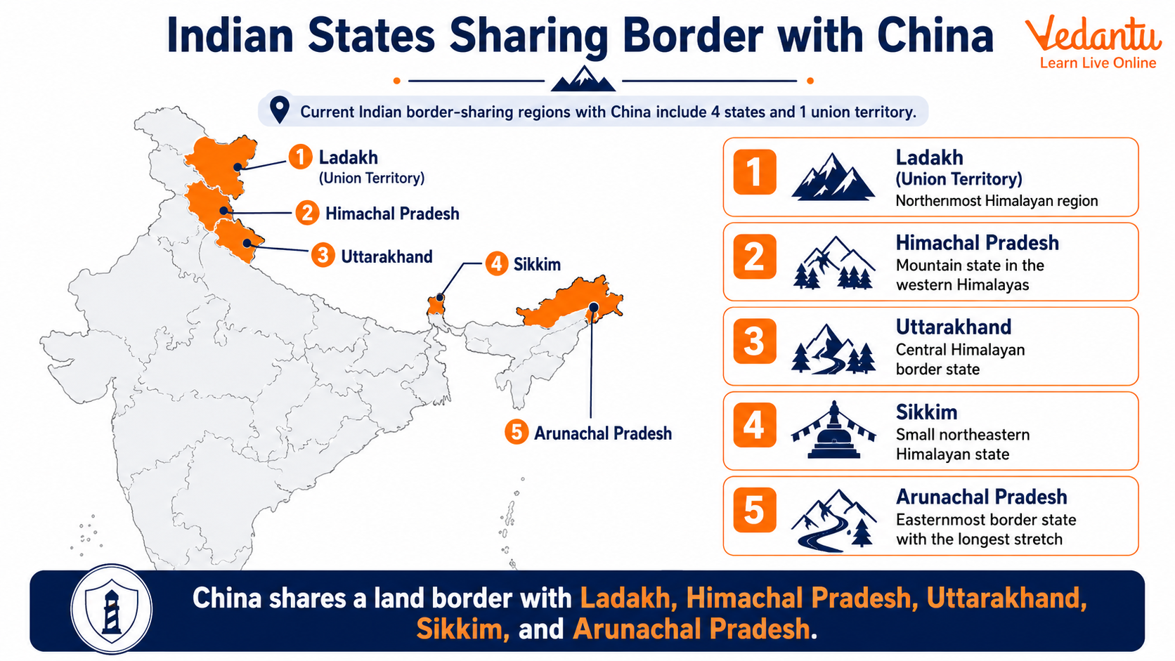
Indian States That Share Boundary With China
India shares its border with China through five administrative regions. These include four states and one union territory. The boundary runs from the western sector in Ladakh to the eastern sector in Arunachal Pradesh.
States and Union Territory Sharing Border With China
| State / Union Territory | Region of Border | Key Geographic Feature |
|---|---|---|
| Ladakh (UT) | Western Sector | Aksai Chin, Karakoram Range |
| Himachal Pradesh | Middle Sector | Shipki La Pass |
| Uttarakhand | Middle Sector | Lipulekh Pass |
| Sikkim | Eastern Sector | Nathu La Pass |
| Arunachal Pradesh | Eastern Sector | McMahon Line |
These five regions together form the India-China border, which is approximately 3,488 kilometers long according to Indian estimates. The border is divided into three sectors - Western, Middle, and Eastern - for administrative and strategic purposes.
Sector Wise Explanation of the India-China Border
1. Western Sector - Ladakh
The western sector lies in the Union Territory of Ladakh. This region includes Aksai Chin, which is currently under Chinese control but claimed by India. The terrain is cold desert and mountainous. Important areas include:
- Galwan Valley
- Pangong Lake
- Depsang Plains
- Karakoram Pass
This sector has witnessed several military stand-offs and is strategically very sensitive.
2. Middle Sector - Himachal Pradesh and Uttarakhand
The middle sector is comparatively less disputed than the western and eastern sectors. It passes through:
- Himachal Pradesh - Shipki La Pass
- Uttarakhand - Lipulekh Pass and Mana Pass
These passes are important for trade, pilgrimage routes such as Kailash Mansarovar Yatra, and border management.
3. Eastern Sector - Sikkim and Arunachal Pradesh
The eastern sector includes Sikkim and Arunachal Pradesh. The boundary in Arunachal Pradesh follows the McMahon Line, which was drawn during the 1914 Simla Convention.
- Sikkim - Nathu La and Jelep La Passes
- Arunachal Pradesh - Tawang region
China claims Arunachal Pradesh as South Tibet, making this sector strategically important. However, Sikkim's boundary is relatively settled compared to Arunachal Pradesh.
Important Facts for Competitive Exams
- India shares its border with China through 4 states and 1 union territory.
- Arunachal Pradesh has the longest border with China among all Indian states.
- The Line of Actual Control separates Indian-controlled territory from Chinese-controlled territory.
- Nathu La in Sikkim is an important trade route between India and China.
- Lipulekh Pass in Uttarakhand is significant for the Kailash Mansarovar Yatra.
Why This Topic Is Important in General Knowledge
The states sharing boundaries with China are frequently asked in static GK and geography sections of competitive examinations. Questions may be asked in the form of multiple choice questions, match the following, or map based identification. Understanding the sector division, important passes, and strategic regions helps in scoring better in exams and improves overall awareness of India's geopolitical position.
Quick Revision List
- Ladakh - Western Sector
- Himachal Pradesh - Middle Sector
- Uttarakhand - Middle Sector
- Sikkim - Eastern Sector
- Arunachal Pradesh - Eastern Sector
In summary, India shares its boundary with China through Ladakh, Himachal Pradesh, Uttarakhand, Sikkim, and Arunachal Pradesh. These regions are geographically mountainous, strategically sensitive, and geopolitically significant. A clear understanding of these states and their sector classification is essential for mastering Indian geography and performing well in competitive examinations.
FAQs on Indian States Sharing Border with China: Complete Guide for Students
1. Which Indian states share boundaries with China?
The Indian states that share boundaries with China are located along the northern and northeastern Himalayas. These states include:
• Ladakh (Union Territory)
• Himachal Pradesh
• Uttarakhand
• Sikkim
• Arunachal Pradesh
These regions form the India–China border, also known as the Line of Actual Control (LAC), which is strategically important for national security and geography GK preparation.
2. How many Indian states share a border with China?
A total of five Indian states/UTs share a border with China. These are:
• Ladakh (UT)
• Himachal Pradesh
• Uttarakhand
• Sikkim
• Arunachal Pradesh
This northern boundary forms part of the 3,488 km long India–China border, a frequently asked topic in UPSC, SSC, and other competitive exams.
3. What is the Line of Actual Control (LAC)?
The Line of Actual Control (LAC) is the de facto border between India and China. Key facts include:
• It separates Indian-controlled territory from Chinese-controlled territory.
• It stretches across Ladakh, Himachal Pradesh, Uttarakhand, Sikkim, and Arunachal Pradesh.
• It was established after the 1962 India–China War.
The LAC is central to discussions about border disputes, Galwan Valley, and Arunachal Pradesh claims.
4. Which Indian state shares the longest border with China?
Among Indian states, Arunachal Pradesh shares the longest border with China. Important points include:
• China refers to Arunachal Pradesh as "South Tibet".
• It is a major area of territorial dispute.
• It lies in the eastern sector of the India–China boundary.
This region is frequently mentioned in GK questions about India-China relations and border conflicts.
5. Does Sikkim share a border with China?
Yes, Sikkim shares a border with China in the northeastern part of India. Key details include:
• The border lies near the Nathu La Pass.
• It connects India with China’s Tibet Autonomous Region.
• Nathu La is an important trade route and strategic pass.
Sikkim is often highlighted in questions about mountain passes and Himalayan geography.
6. Which Union Territory shares a boundary with China?
The Union Territory of Ladakh shares a boundary with China. Important facts include:
• It lies in the western sector of the India–China border.
• Major disputed areas include Aksai Chin and Galwan Valley.
• It was formed as a Union Territory in 2019.
Ladakh is strategically important in discussions on border security and India-China military tensions.
7. Why is Arunachal Pradesh important in India-China relations?
Arunachal Pradesh is important because it is a major disputed territory between India and China. Key reasons include:
• China claims it as part of South Tibet.
• It shares the longest eastern border with China.
• It has strategic and cultural significance.
This state frequently appears in questions related to India-China dispute, border tensions, and international relations GK.
8. Which mountain range forms the natural boundary between India and China?
The Himalayan Mountain Range forms the natural boundary between India and China. Key features include:
• It includes the Karakoram, Zanskar, and Eastern Himalayas.
• It contains important passes like Nathu La and Shipki La.
• It acts as a natural climatic and political barrier.
The Himalayas are central to understanding Indian geography, physical features, and international borders.
9. What happened during the 1962 India-China War?
The 1962 India-China War was a border conflict between India and China over disputed territories. Key points include:
• It occurred in October–November 1962.
• Major fighting happened in Ladakh and Arunachal Pradesh.
• It led to the establishment of the Line of Actual Control (LAC).
This war is a significant topic in modern Indian history and international relations.
10. Which countries share borders with China apart from India?
Apart from India, China shares borders with 13 other countries. These include:
• Russia, Mongolia, North Korea
• Vietnam, Laos, Myanmar
• Bhutan, Nepal, Pakistan
• Afghanistan, Tajikistan, Kyrgyzstan, Kazakhstan
China has one of the highest numbers of neighboring countries, making it important in world geography and border GK questions.