


Causes and History of the Siachen Glacier Dispute Between India and Pakistan
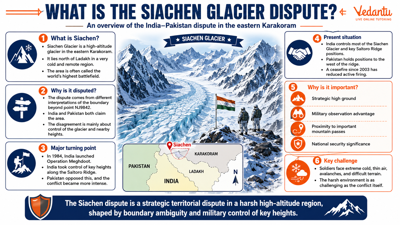
The Siachen Glacier dispute is one of the longest-running and highest-altitude military conflicts in the world. It is a territorial conflict between India and Pakistan over the Siachen Glacier region in the eastern Karakoram Range in the Himalayas. Known as the highest battlefield on Earth, the region holds strategic military importance despite its extreme weather conditions and harsh terrain. Understanding the Siachen dispute is essential for students preparing for competitive exams and for anyone interested in India’s geography, geopolitics, and international relations.
Location and Geographical Significance
The Siachen Glacier is located in the northern part of Ladakh, near the Line of Control - LoC - between India and Pakistan. It lies just south of the Saltoro Ridge and close to the China border. The glacier is about 76 kilometers long, making it one of the longest glaciers in the Karakoram Range.
- Situated at an altitude of about 5,400 meters above sea level
- Source of the Nubra River, a tributary of the Indus River
- Extremely cold climate with temperatures dropping below -50 degrees Celsius
- Covered by snow throughout the year
Its location near the borders of India, Pakistan, and China gives it strategic importance in terms of defense and surveillance.
Background of the Siachen Glacier Dispute
The roots of the Siachen dispute lie in the incomplete demarcation of the Line of Control after the 1949 Karachi Agreement and later the 1972 Simla Agreement. The boundary was clearly marked only up to a point called NJ9842. Beyond this point, the agreement stated that the line would run "north to the glaciers," but it did not clearly define the exact boundary.
This ambiguity led both India and Pakistan to claim the Siachen Glacier region. In the 1970s and early 1980s, Pakistan allowed foreign mountaineering expeditions in the area, indicating its claim over the glacier.
Operation Meghdoot
In April 1984, India launched Operation Meghdoot to take control of key passes along the Saltoro Ridge, including Sia La and Bilafond La. The Indian Army successfully occupied strategic heights before Pakistan could do so. Since then, India has maintained control over most of the glacier and the dominating heights.
Reasons for the Dispute
- Unclear boundary demarcation: The Line of Control beyond NJ9842 was not clearly defined.
- Strategic advantage: Control over Saltoro Ridge provides military advantage and surveillance over surrounding areas.
- Proximity to China: The region is close to the China-Pakistan border, increasing its geopolitical importance.
- National security concerns: Both countries view control of the glacier as vital for defense.
Key Facts About the Siachen Glacier Dispute
| Aspect | Details | Importance |
|---|---|---|
| Location | Eastern Karakoram Range, Ladakh | Strategic border region |
| Start of Conflict | 1984 - Operation Meghdoot | India gained control of key heights |
| Altitude | Around 5,400 meters | Highest battlefield in the world |
The table highlights the essential aspects of the Siachen dispute, including its location, timeline, and strategic importance. These facts are frequently asked in competitive examinations.
Impact of the Conflict
Human Cost
Most casualties in the Siachen region are due to extreme weather conditions rather than direct combat. Soldiers face avalanches, frostbite, oxygen deficiency, and harsh winds.
Economic Cost
Maintaining troops and supplies at such high altitudes is extremely expensive. Both India and Pakistan spend significant resources to sustain their presence in the glacier.
Environmental Concerns
Military activities have raised concerns about environmental damage to the fragile glacier ecosystem. Waste disposal and fuel use have impacted the region’s natural balance.
Attempts at Resolution
India and Pakistan have held several rounds of talks to resolve the Siachen dispute. However, differences remain over the authentication of current troop positions before any withdrawal.
- Proposal for mutual withdrawal of troops
- Demand for recording present positions on the ground
- Confidence-building measures between both countries
Despite negotiations, no final agreement has been reached, and the region remains militarized.
Why the Siachen Glacier Dispute Is Important for Exams
- Frequently asked in General Knowledge and current affairs sections
- Important for understanding India-Pakistan relations
- Relevant in geography, political science, and defense studies
- Helps in essays and interviews in competitive exams
Conclusion
The Siachen Glacier dispute is a significant territorial conflict between India and Pakistan rooted in unclear boundary demarcation and strategic concerns. Located in one of the harshest environments on Earth, it represents not only a military challenge but also a symbol of geopolitical rivalry in South Asia. For students and exam aspirants, understanding its history, causes, and implications is essential for building strong knowledge in General Studies and international relations.
FAQs on Siachen Glacier Dispute Explained for Students
1. What is the Siachen Glacier dispute?
The Siachen Glacier dispute is a long-standing territorial conflict between India and Pakistan over control of the Siachen Glacier in the eastern Karakoram Range.
- It began in 1984 when India launched Operation Meghdoot to secure key heights.
- The dispute centers around the undefined boundary beyond point NJ9842 in the Line of Control (LoC).
- It is considered the highest battlefield in the world.
- The issue is linked to broader India-Pakistan tensions over Kashmir conflict and border demarcation.
2. Where is the Siachen Glacier located?
The Siachen Glacier is located in the eastern Karakoram Range in the Himalayas, near the India-Pakistan border.
- It lies north of Point NJ9842.
- It is situated between the Saltoro Ridge (west) and the main Karakoram Range (east).
- The glacier is part of the disputed region of Ladakh.
- It is approximately 76 km long, making it one of the longest glaciers in the Karakoram region.
3. Why is the Siachen Glacier strategically important?
The Siachen Glacier is strategically important due to its high-altitude location and proximity to key borders.
- It overlooks vital passes like Sia La and Bilafond La.
- Control of the Saltoro Ridge provides military advantage.
- It lies near the borders of China, Pakistan, and India.
- It strengthens India's security in Ladakh and counters possible strategic alliances.
4. What led to the Siachen conflict in 1984?
The Siachen conflict began due to differing interpretations of the Simla Agreement (1972) and unclear boundary demarcation.
- The LoC was defined only up to NJ9842.
- Pakistan interpreted the boundary as extending northeast toward the Karakoram Pass.
- India launched Operation Meghdoot in April 1984 to preempt Pakistani moves.
- Since then, both countries have maintained military presence in the glacier region.
5. What is Operation Meghdoot?
Operation Meghdoot was a military operation launched by India in April 1984 to gain control of the Siachen Glacier.
- Indian troops occupied key heights along the Saltoro Ridge.
- It prevented Pakistan from taking control of the glacier.
- It marked the beginning of continuous military deployment in the region.
- The operation made Siachen the world’s highest battlefield.
6. Why is Siachen called the highest battlefield in the world?
Siachen is called the highest battlefield in the world because troops are stationed at extreme altitudes above 6,000 meters.
- Soldiers face temperatures below -50°C.
- Harsh weather causes more casualties than combat.
- The terrain includes glaciers, crevasses, and avalanches.
- It represents one of the most challenging military deployments globally.
7. What role does the Line of Control (LoC) play in the Siachen dispute?
The Line of Control (LoC) is central to the Siachen dispute due to incomplete boundary marking.
- The LoC was defined up to NJ9842 under the Simla Agreement.
- Beyond that point, the agreement stated "thence north to the glaciers," creating ambiguity.
- India and Pakistan interpret this extension differently.
- This undefined stretch triggered the Siachen conflict.
8. Have there been peace talks regarding the Siachen Glacier?
Yes, India and Pakistan have held several peace talks to resolve the Siachen dispute.
- Multiple rounds of defense-level talks have occurred since the 1980s.
- The main issue is authentication of current troop positions.
- India insists on documented demarcation before withdrawal.
- Despite negotiations, no final agreement has been reached.
9. What are the environmental impacts of the Siachen conflict?
The military presence in Siachen has caused significant environmental damage to the fragile glacier ecosystem.
- Waste disposal affects glacier purity.
- Melting ice contributes to ecological imbalance.
- The region is part of the sensitive Himalayan environment.
- Environmentalists call Siachen the "Third Pole" due to its vast ice reserves.
10. Why is the Siachen dispute important for competitive exams and GK?
The Siachen Glacier dispute is important for General Knowledge and competitive exams due to its geopolitical and strategic significance.
- Frequently asked in exams like UPSC, SSC, NDA, CDS.
- Linked to topics such as India-Pakistan relations, Kashmir issue, and border disputes.
- Involves key terms like Operation Meghdoot, Saltoro Ridge, and Simla Agreement.
- Helps understand India’s defense strategy and high-altitude warfare.