


Class 12 Geography Chapter 8 International Trade Important Questions with Answers PDF
This practice set contains 22 important questions organised into five MCQs, four very short answers, seven short answers and six long answers. The questions include historical trade statistics for 2015–2022, trade-balance calculations, analysis of export and import commodities, important ports on both coasts, and map-based questions on India's sea and air routes.
Class 12 India People and Economy Chapter 8 Important Questions MCQ
Q1. Which commodity group contributed the largest share of India's exports in 2021–22?
(a) Agriculture and allied products
(b) Ore and minerals
(c) Manufactured goods
(d) Other commodities
Answer: (c) Manufactured goods.
Explanation: Manufactured goods accounted for 67.8% of India's exports in 2021–22. The textbook also highlights engineering goods and gems and jewellery as important export items.
Q2. India's exports were worth ₹18,52,340 crore, and imports were worth ₹25,77,422 crore in 2016–17. What was the trade balance?
(a) ₹7,25,082 crore surplus
(b) ₹7,25,082 crore deficit
(c) ₹44,29,762 crore surplus
(d) Zero trade balance
Answer: (b) ₹7,25,082 crore deficit.
Explanation: Trade balance is calculated by subtracting imports from exports.
18,52,340 - 25,77,422 = -7,25,082
The negative value shows a trade deficit.
Q3. Which of the following Indian ports is described as a landlocked harbour connected to the sea through a channel?
(a) Mumbai
(b) Chennai
(c) Visakhapatnam
(d) Kamarajar (Ennore)
Answer: (c) Visakhapatnam.
Explanation: Visakhapatnam Port in Andhra Pradesh has a landlocked harbour connected to the sea by a channel cut through rock and sand. It handles commodities such as iron ore, petroleum and general cargo.
Q4. Which port was developed at Nhava Sheva to reduce congestion at Mumbai Port?
(a) Mormugao Port
(b) Jawaharlal Nehru Port
(c) Paradip Port
(d) Haldia Port
Answer: (b) Jawaharlal Nehru Port.
Explanation: Jawaharlal Nehru Port was developed as a satellite port of Mumbai. It is recognised as an important container port developed to reduce pressure on Mumbai.
Q5. Which region accounted for the highest value of India's imports in 2021–22 among the regions listed in the chapter?
(a) Europe
(b) Africa
(c) North America
(d) Asia and ASEAN
Answer: (d) Asia and ASEAN.
Explanation: The textbook records imports worth ₹29,18,577 crore from Asia and ASEAN in 2021–22, higher than the values reported for the other listed regions.
Class 12 Geography Chapter 8 Very Short Answer Questions
Q6. What is international trade?
Answer: International trade is the exchange of goods and services between countries through imports and exports. It allows countries to obtain products that they do not produce sufficiently or economically.
Q7. What is the balance of trade? When is it unfavourable?
Answer: The balance of trade is the difference between the value of exports and imports of goods.
It is unfavourable when the value of imports exceeds exports, resulting in a trade deficit.
Q8. What is a port hinterland?
Answer: A port hinterland is the inland area served by a port, from which goods are collected for export and to which imported goods are distributed. The hinterlands of different ports can overlap.
Q9. Name four major ports located on India's eastern coast.
Answer: Four major eastern-coast ports are:
Shyama Prasad Mookerjee (Kolkata) Port.
Paradip Port.
Visakhapatnam Port.
Chennai Port.
Other examples include Kamarajar (Ennore) and V.O. Chidambaranar (Tuticorin) ports.
Class 12 Geography Chapter 8 Short Answer Questions
Q10. Explain why India's international trade increased considerably after 1950–51.
Answer: India's international trade increased as the economy expanded and became more connected with overseas markets.
The value of India's external trade increased from ₹1,214 crore in 1950–51 to ₹77,19,796 crore in 2020–21.
The major reasons were:
1. Manufacturing Growth: Expansion of industries increased the production of goods for export and the demand for imported inputs.
2. Trade Liberalisation: Government policies encouraged greater participation in international trade.
3. Market Diversification: Indian businesses developed trading relationships with more countries and regions.
4. Growing Industrial Requirements: Industries needed imported machinery, raw materials, petroleum and other goods.
5. Expansion of Overseas Markets: Improved commercial connections increased the movement of goods between India and other countries.
Q11. Differentiate between a port and a harbour with examples from India.
Answer: Although ports and harbours are closely related, they are not identical.
Explanation: A harbour provides a suitable place for ships, while a port uses that location and associated infrastructure to support trade.
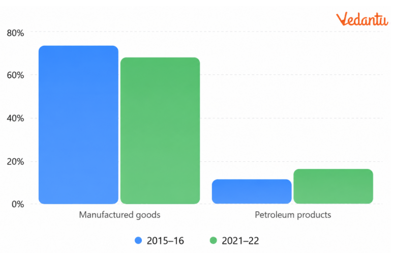
Q12. Using the export data given in the chapter, compare the share of manufactured goods and crude petroleum products in India's exports during 2015–16 and 2021–22.
Answer:
1. Manufactured Goods
The share of manufactured goods declined from 72.9% to 67.8%.
However, manufactured goods remained the largest export category in 2021–22.
2. Crude and Petroleum Products
Their share increased from 11.9% to 16.4%, indicating a greater contribution to the export composition in the later year.
3. Overall Observation
The relative importance of different export commodities changed between these years.
Q13. Why did foodgrain imports decline after the 1970s, while petroleum became an important import item?
Answer: India's import composition changed as agricultural production and industrial requirements increased.
1. Food Shortages During the 1950s and 1960s: India imported foodgrains because domestic production was insufficient to meet demand.
2. Success of the Green Revolution: The Green Revolution increased foodgrain production, reducing dependence on imported foodgrains.
3. Energy Crisis of 1973: The increase in international petroleum prices raised India's petroleum import expenditure.
4. Growing Industrial Demand: Petroleum became important as both a fuel and an industrial raw material.
5. Changing Import Requirements: India increasingly imported petroleum, fertilisers, machinery, chemicals and other goods required for economic activities.
Q14. Explain why India imports edible oils despite having a large agricultural sector.
Answer: India has a large agricultural sector, but domestic production of every agricultural commodity does not always meet national demand.
The reasons for importing edible oils include:
Demand and supply differences: Domestic edible oil production may be insufficient to meet consumption requirements.
Changing consumption: Demand for edible oils can increase with population and consumption patterns.
Agricultural priorities: Land, water and other agricultural resources are also used for foodgrains and different crops.
Import availability: International markets help meet requirements when domestic supplies are insufficient.
Q15. Explain the major differences between sea transport and air transport in international trade.
Answer: Sea and air transport both connect India with international markets, but they serve different requirements.
Importance of Sea Transport: Sea transport provides a comparatively low-cost means of moving large quantities of goods.
Importance of Air Transport: Air transport reduces travel time and is suitable for goods that require quick delivery.
Q16. Why is a port's hinterland important? Explain with Mumbai and Cochin ports.
Answer: The hinterland of a port is the inland region connected to it for the movement of goods.
1. Importance of a Hinterland
A port depends on its hinterland for cargo, markets and inland transport connections.
2. Mumbai Port
Mumbai's hinterland includes:
Maharashtra.
Gujarat.
Madhya Pradesh.
Uttar Pradesh.
Parts of Rajasthan.
Its connections with industrial and agricultural regions support substantial trade.
3. Cochin Port
Cochin Port serves:
Kerala.
Southern Karnataka.
South-western Tamil Nadu.
Its location near the Suez–Colombo route contributes to its importance.
4. Overlapping Hinterlands
The limits of a port's hinterland are not fixed. The areas served by different ports may overlap.
Class 12 Geography Chapter 8 Long Answer Questions
Q17. Examine the changing composition of India's exports between 2015–16 and 2021–22. What do these changes reveal about India's international trade?
Answer: India's export composition has changed as manufacturing, agricultural trade and petroleum-related activities have developed.
1. Composition of India's Exports
2. Manufactured Goods
Manufactured goods remained the largest export category, although their percentage share decreased from 72.9% to 67.8%.
Engineering goods and gems and jewellery are among the important items discussed in the textbook.
3. Agricultural and Allied Products
Their share declined from 12.6% in 2015–16 to 11.9% in 2021–22.
The chapter explains that traditional agricultural export items face international competition.
It also notes growth in certain products, including flowers, fresh fruits, marine products and sugar.
4. Ore and Minerals
The export share of ore and minerals remained relatively small compared with manufactured goods.
5. Crude and Petroleum Products
Their share rose from 11.9% to 16.4%, showing a significant change in the composition of India's exports.
6. International Competition
The textbook highlights competition from China and other East Asian economies in manufacturing exports.
Q18. Describe the changing composition of India's imports. Explain the importance of petroleum, fertilisers and capital goods.
Answer: The composition of India's imports reflects the changing requirements of agriculture, industries and consumers.
1. Early Import Requirements: During the 1950s and 1960s, foodgrains, capital goods, machinery and equipment were important import commodities.
2. Changes After the Green Revolution: Foodgrain imports declined as domestic agricultural production increased.
3. Increasing Importance of Petroleum: Petroleum imports became important because of industrial requirements and energy consumption. The 1973 energy crisis also increased petroleum import expenditure.
4. Composition of India's Imports
5. Importance of Petroleum: Fuel imports accounted for 31.6% of the import composition shown for 2021–22. Petroleum is used for transport, industry and various economic activities.
6. Importance of Fertilisers: Fertilisers help support agricultural production and form part of India's import requirements.
7. Importance of Capital Goods: Capital goods include equipment and machinery needed for production and development. Their share in the textbook table decreased from 13.0% in 2015–16 to 10.1% in 2021–22.
8. Other Major Imported Commodities: Important imports also include edible oils, precious and semi-precious stones, metals and chemicals.
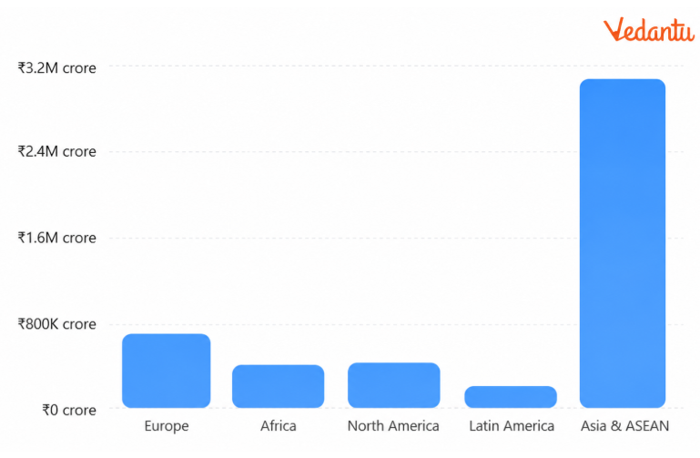
Q19. Analyse the direction of India's import trade in 2021–22. Which regions were its major trading partners?
Answer: The direction of trade shows the countries and regions from which India imports goods or to which it exports products.
India maintains trade relationships with most major regions of the world.
1. Region-wise Imports
2. Asia and ASEAN
Asia and ASEAN accounted for the largest import value among the regions listed.
The import value increased substantially between 2016–17 and 2021–22.
3. Europe
Europe was another important source of imports, with a recorded value of ₹6,40,577 crore in 2021–22.
4. North America and Africa
Both regions supplied substantial imports to India, with their values increasing during the period shown.
5. Latin America
Latin America's import value was comparatively smaller than that of the other listed regions.
6. Importance of Regional Trade
Trade with different regions helps India obtain commodities and inputs from international markets.
Q20. Explain how the Partition of India affected its ports and describe the development of important western-coast ports after Independence.
Answer: Ports provide essential links between India's inland regions and international markets.
The Partition of India in 1947 affected the country's access to important ports and encouraged the development of alternative port facilities.
1. Impact of Partition
Following Partition, India lost access to two important ports:
Karachi Port, which became part of Pakistan.
Chittagong Port, which became part of East Pakistan and later Bangladesh.
This created a need to develop alternative gateways for international trade.
2. Deendayal Port (Kandla)
Located at the head of the Gulf of Kuchchh in Gujarat.
Developed to serve western and north-western India.
Helped reduce pressure on Mumbai Port.
Handles petroleum, petroleum products and fertilisers.
The offshore terminal at Vadinar supports petroleum handling.
3. Mumbai Port
A natural harbour on India's western coast.
Situated near major overseas shipping routes.
Historically important for trade with Europe, North America, West Asia and North Africa.
Serves a large hinterland including Maharashtra, Gujarat, Madhya Pradesh and other inland areas.
4. Jawaharlal Nehru Port
Located at Nhava Sheva near Mumbai.
Developed to relieve congestion at Mumbai Port.
An important container-handling port.
5. Mormugao Port
Located near the entrance to the Zuari estuary in Goa.
Developed significantly to support iron-ore exports.
Its hinterland includes Goa, Karnataka and southern Maharashtra.
The Konkan Railway strengthened its inland connections.
6. New Mangalore Port
Located in Karnataka.
Handles iron ore, iron concentrates, fertilisers, petroleum products and other goods.
Primarily serves Karnataka and adjoining areas.
7. Cochin Port
Located near Vembanad Kayal in Kerala.
A natural harbour, popularly known as the Queen of the Arabian Sea.
Located close to the Suez–Colombo shipping route.
Serves Kerala, southern Karnataka and south-western Tamil Nadu.
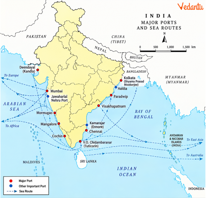
Q21. Compare the major ports on India's eastern coast and explain their geographical and commercial importance.
Answer: India's eastern-coast ports connect the interior regions of the country with overseas markets through the Bay of Bengal.
Their locations, harbours, cargo and hinterlands differ.
1. Shyama Prasad Mookerjee (Kolkata) Port
Located on the Hugli River, approximately 128 km inland from the Bay of Bengal.
Developed during British rule.
Serves West Bengal, Bihar, Jharkhand, Uttar Pradesh, Sikkim and north-eastern India, among other regions.
Faces problems associated with silt accumulation in the Hugli River.
2. Haldia Port
Located approximately 105 km downstream from Kolkata.
Developed to reduce congestion at Kolkata Port.
Handles bulk cargo such as iron ore, coal, petroleum products and fertilisers.
3. Paradip Port
Located in Odisha near the Mahanadi delta.
Developed mainly for large-scale iron-ore exports.
Its hinterland includes Odisha, Chhattisgarh and Jharkhand.
Paradip Port has a deep harbour suitable for large vessels.
4. Visakhapatnam Port
Located in Andhra Pradesh.
Has a landlocked harbour connected to the sea by a channel.
Handles iron ore, petroleum and general cargo.
Andhra Pradesh and Telangana form important parts of its hinterland.
5. Chennai Port
Located in Tamil Nadu.
One of the oldest ports on the eastern coast.
An artificial harbour.
The textbook notes limitations associated with shallow coastal waters.
6. Kamarajar (Ennore) Port
Located approximately 25 km north of Chennai.
Developed to reduce pressure on Chennai Port.
7. V.O. Chidambaranar (Tuticorin) Port
Located in Tamil Nadu.
Handles coal, salt, foodgrains, edible oils, sugar, chemicals and petroleum products.
Its development also helped distribute cargo pressure away from Chennai.
Comparison Table
Q22. Discuss the importance of seaports and airports in India's international trade. Why do different commodities use different transport routes?
Answer: Seaports and airports are gateways through which India exchanges goods with overseas markets.
Their importance depends on transport cost, cargo volume, speed and the type of commodity being transported.
1. Importance of Seaports
India has a long coastline and a historical tradition of maritime trade.
Seaports handle large cargo quantities and connect inland markets with overseas destinations.
2. Transporting Heavy and Bulky Goods
Sea transport is suitable for large quantities of petroleum, iron ore, coal, fertilisers and other bulk commodities.
Its cost advantage makes it important for long-distance trade.
3. Importance of Airports
Air transport provides faster movement of goods over long distances.
It is particularly useful for high-value, perishable and time-sensitive cargo.
4. Limitations of Air Transport
Air transport is relatively expensive and is generally unsuitable for heavy and bulky commodities.
5. Role of Inland Connections
Ports depend on roads, railways and other transport links to move imported and exported goods between coastal terminals and inland markets.
6. Different Transport Requirements
7. Air Routes in India
The air-route map shows India's network of air routes, with important connections through cities such as Delhi, Mumbai, Kolkata, Chennai, Bengaluru and Hyderabad.
These routes connect different regions and major urban centres.
8. Changing Transport Infrastructure
The chapter also discusses improved airport connectivity under the UDAN scheme, citing figures available up to 2023.
Why Practise Class 12 Geography Chapter 8 Important Questions with Vedantu?
Vedantu's International Trade Class 12 Important Questions help students understand how India's imports and exports have changed, why trade deficits occur and how trade routes connect Indian markets with other countries. The questions use historical trade statistics, major port examples and chapter maps to help students prepare for CBSE examinations.
How to Prepare Class 12 Geography Chapter 8 Important Questions with Vedantu?
Compare export and import composition: Learn the major commodity groups and their changing shares.
Learn ports with their features: Associate each major port with its state, location, cargo and hinterland.
Revise trade routes: Understand why sea transport is used for bulk cargo and air transport for time-sensitive goods.
Practise important explanations: Practise questions on the Green Revolution, petroleum imports, trade liberalisation and the effects of Partition.
Important Study Material Links for Class 12 Geography Chapter 8
CBSE Class 12 Geography other books Important Questions and Study Resources
Chapter-Wise Important Questions for Class 12 Geography (India: People and Economy)
Important Study Materials for Class 12 Geography
FAQs on Important Questions and Answers for Class 12 Geography Chapter 8 – International Trade (India: People and Economy) | 2026-27
1. Why did India's international trade increase significantly between 1950–51 and 2020–21?
India's international trade increased because of industrial growth, manufacturing expansion, liberalisation of trade policies, and access to more international markets. As the historical trade data shows, the value of India's external trade rose from ₹1,214 crore in 1950–51 to ₹77,19,796 crore in 2020–21. Growing demand for petroleum, machinery, and industrial inputs also contributed to the expansion of trade.
2. Why is international trade important for India?
International trade allows India to export goods and import commodities needed for domestic consumption and production. It connects Indian industries and markets with other countries and supports economic activities.
3. Why does India have a negative balance of trade in the historical trade data?
India has a negative trade balance in the textbook's selected years because imports exceed exports. Imports of petroleum and other commodities contribute to the country's import expenditure.
4. Which commodity group had the highest share in India's exports in 2021–22?
Manufactured goods had the highest share, contributing 67.8% of India's total exports in 2021–22, according to the 2021–22 export data.
5. Why did India's foodgrain imports decrease after the Green Revolution?
The Green Revolution increased domestic foodgrain production and reduced India's dependence on imported foodgrains. The import composition subsequently shifted towards commodities such as petroleum, fertilisers and industrial inputs.
6. What is the difference between a trade deficit and a trade surplus?
A trade deficit occurs when imports are worth more than exports. A trade surplus occurs when exports are worth more than imports. Both are calculated by comparing the value of exported and imported goods.
7. What is the difference between a port and a harbour?
A harbour is a sheltered water area where ships can anchor safely. A port is a transport and trade facility where ships can load and unload goods or passengers, generally with supporting infrastructure.
8. What is the importance of a port's hinterland?
A hinterland is the inland area served by a port. It provides cargo for export and receives imported goods. A port with good transport connections to its hinterland can serve larger markets.
9. Which important Indian ports are located on the western coast?
Important western-coast ports in the chapter include Deendayal (Kandla), Mumbai, Jawaharlal Nehru, Mormugao, New Mangalore and Cochin.
10. Which Indian port is known as a land-locked harbour?
Visakhapatnam Port in Andhra Pradesh is described as a land-locked harbour connected to the sea through a channel.
11. Why was Jawaharlal Nehru Port developed near Mumbai?
Jawaharlal Nehru Port at Nhava Sheva was developed to reduce congestion at Mumbai Port and improve container-handling facilities.
12. Why is Kolkata Port affected by silt accumulation?
Kolkata Port is located inland on the Hugli River. Sediment accumulation in the river makes navigation difficult and contributes to the port's operational challenges.
13. Why are seaports more suitable for bulk international cargo than airports?
Seaports can handle large quantities of heavy and bulky goods at comparatively low transport costs. Air transport is faster but more expensive and is better suited to time-sensitive or high-value products.
14. Which region accounted for the highest value of India's imports in 2021–22?
Asia and ASEAN accounted for the highest import value among the regions presented in the 2021–22 regional import data, with imports valued at ₹29,18,577 crore.
15. How should students prepare map-based questions from International Trade Chapter 8?
Students should practise locating major ports on India's eastern and western coasts using the chapter maps. They should also revise each port's location, important features and hinterland, along with the major air routes connecting Indian cities.