


Which Is the Biggest State in India by Area?
India is the seventh-largest country in the world and is divided into 28 states and 8 Union Territories. The states of India vary significantly in terms of area, population, geography, culture, and economic importance. Understanding the largest states of India by area is an important topic in General Knowledge and is frequently asked in competitive exams such as UPSC, SSC, Banking, Railways, and various state-level examinations. This article provides a detailed and structured overview of the largest states of India, along with key facts and important points for exam preparation.
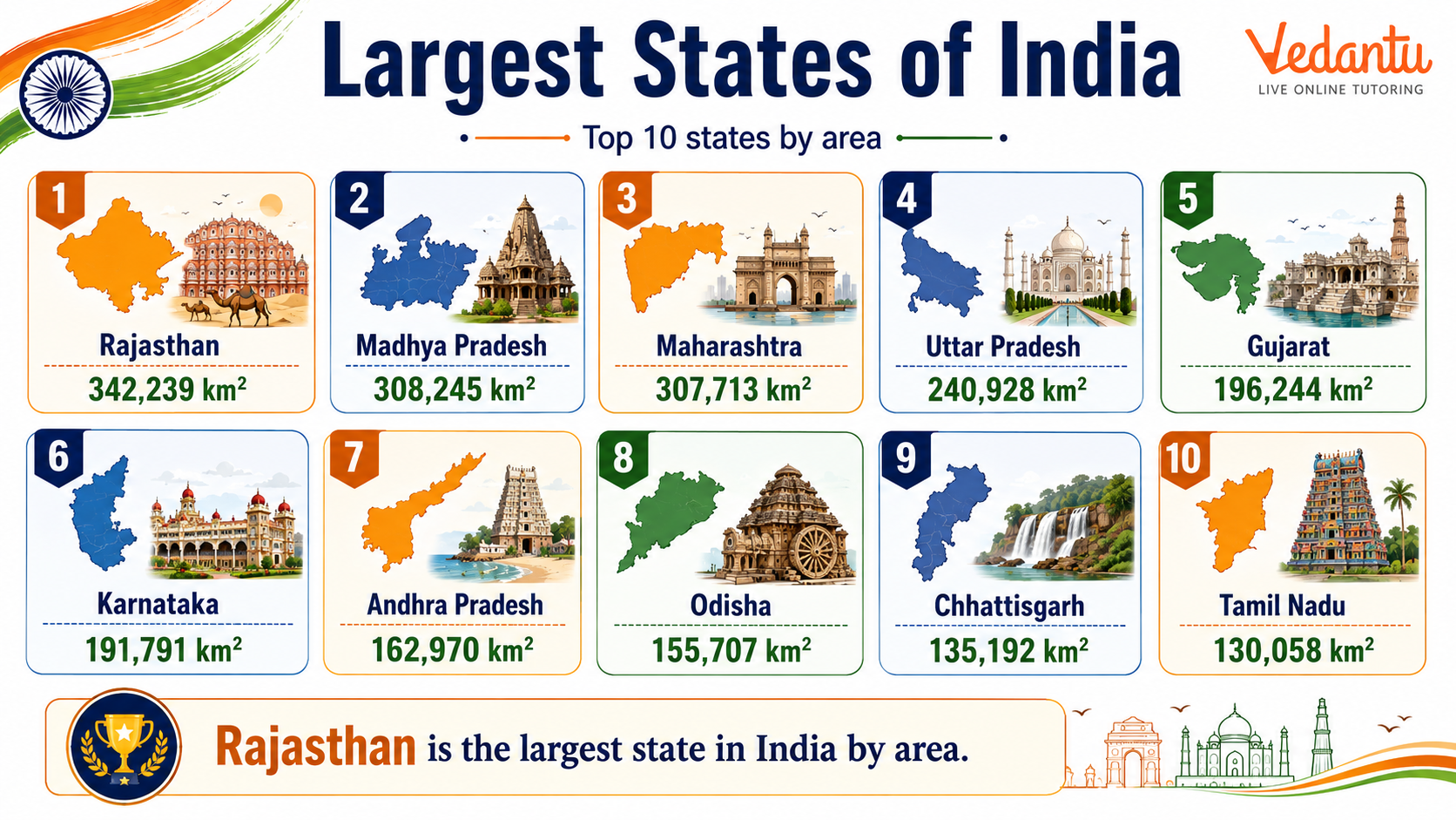
Largest States of India by Area
The largest states in India are ranked according to their total geographical area. Rajasthan holds the first position as the largest state in India by area, followed by Madhya Pradesh and Maharashtra. These states play a significant role in India’s geography, economy, and cultural diversity.
Top 10 Largest States of India by Area
| Rank | State | Area (in sq km) |
|---|---|---|
| 1 | Rajasthan | 342,239 |
| 2 | Madhya Pradesh | 308,245 |
| 3 | Maharashtra | 307,713 |
| 4 | Uttar Pradesh | 240,928 |
| 5 | Gujarat | 196,024 |
| 6 | Karnataka | 191,791 |
| 7 | Andhra Pradesh | 162,975 |
| 8 | Odisha | 155,707 |
| 9 | Chhattisgarh | 135,192 |
| 10 | Tamil Nadu | 130,058 |
Rajasthan covers approximately 10.4 percent of India’s total geographical area, making it the largest state. These states differ widely in physical features such as deserts, plateaus, coastal plains, and forests.
About the Top 3 Largest States
1. Rajasthan
Rajasthan is located in north-western India and is known for the Thar Desert, historical forts, and rich cultural heritage. Jaipur is its capital. The state shares an international border with Pakistan and has diverse geographical features including desert, plains, and the Aravalli Range.
2. Madhya Pradesh
Madhya Pradesh is situated in central India and is often called the Heart of India due to its central location. Bhopal is the capital city. The state is known for its forests, wildlife sanctuaries, and historical monuments such as Khajuraho temples and Sanchi Stupa.
3. Maharashtra
Maharashtra is located in western India and is one of the most economically developed states. Mumbai, the financial capital of India, is its capital. The state has coastal areas along the Arabian Sea and includes the Deccan Plateau region.
Key Facts About the Largest States of India
- Rajasthan became the largest state after the reorganization of states in 1956.
- Madhya Pradesh was the largest state before Chhattisgarh was carved out in 2000.
- Uttar Pradesh is the most populous state but not the largest by area.
- The geographical diversity of large states includes deserts, forests, plateaus, and coastal regions.
- Large states often have multiple climatic zones due to their vast area.
Why This Topic is Important for Exams
Questions related to the largest states of India are common in competitive examinations. Candidates may be asked to identify the largest or second-largest state, arrange states in descending order of area, or match states with their capitals. Understanding this topic also helps in geography-based questions related to rivers, climate, agriculture, and natural resources.
Preparation Tips
- Memorize the top 10 largest states in order of area.
- Learn the capitals and important geographical features of each state.
- Practice map-based questions to improve retention.
- Revise frequently using short notes and tables.
Conclusion
The largest states of India by area reflect the geographical vastness and diversity of the country. Rajasthan, Madhya Pradesh, and Maharashtra occupy the top three positions and play significant roles in India’s cultural and economic landscape. A clear understanding of the ranking, area, and key features of these states is essential for students and competitive exam aspirants. Regular revision of state rankings and geographical characteristics ensures better performance in General Knowledge sections.
FAQs on Largest States of India: List by Area and Key Facts
1. Which is the largest state of India by area?
Rajasthan is the largest state of India by area, covering about 342,239 square kilometres.
• Located in northwestern India
• Accounts for nearly 10.4% of India’s total geographical area
• Known for the Thar Desert, also called the Great Indian Desert
• Capital city: Jaipur
This is a common GK question in competitive exams asking, "What is the biggest state in India by area?"
2. Which is the largest state of India by population?
Uttar Pradesh is the largest state of India by population, with over 200 million people as per recent census data.
• Located in northern India
• Capital: Lucknow
• Plays a major role in Indian politics and elections
• Often searched as "most populated state in India" or "largest state by population"
It is also the most represented state in the Lok Sabha.
3. Which is the second largest state in India by area?
Madhya Pradesh is the second largest state in India by area after Rajasthan.
• Total area: Around 308,245 square kilometres
• Located in central India
• Known as the "Heart of India"
• Capital: Bhopal
This question is frequently asked in GK quizzes and state-wise ranking topics.
4. Which is the smallest state of India by area?
Goa is the smallest state of India by area.
• Covers only 3,702 square kilometres
• Located on the western coast of India
• Known for its beaches and tourism
• Capital: Panaji
Students often compare Goa with Rajasthan when studying largest and smallest Indian states.
5. Which is the largest state in South India by area?
Karnataka is the largest state in South India by area.
• Area: About 191,791 square kilometres
• Capital: Bengaluru
• Known as India’s IT hub
• Larger than Tamil Nadu, Kerala, Andhra Pradesh, and Telangana
This is commonly searched as "biggest South Indian state by area."
6. Which are the top 5 largest states of India by area?
The top 5 largest states of India by area are ranked based on their geographical size.
1. Rajasthan
2. Madhya Pradesh
3. Maharashtra
4. Uttar Pradesh
5. Gujarat
These rankings are important for competitive exams and general knowledge about Indian geography.
7. Why is Rajasthan the largest state of India important?
Rajasthan is important not only for its size but also for its cultural and geographical significance.
• Home to the Thar Desert
• Rich in Rajput history and heritage
• Famous tourist cities: Jaipur, Udaipur, Jodhpur
• Shares an international border with Pakistan
It is often discussed in topics like "largest Indian state" and "Indian desert region."
8. How many states are larger than 3 lakh square kilometres in India?
Only two Indian states have an area larger than 3 lakh (300,000) square kilometres.
• Rajasthan – 342,239 sq km
• Madhya Pradesh – 308,245 sq km
These two dominate the list of largest states of India by geographical area.
9. Is Uttar Pradesh larger than Maharashtra in area?
No, Maharashtra is larger than Uttar Pradesh in terms of area.
• Maharashtra: About 307,713 sq km
• Uttar Pradesh: About 240,928 sq km
• However, Uttar Pradesh has a higher population
This comparison is common in GK questions about largest Indian states by area and population.
10. What is the difference between largest state by area and by population in India?
The largest state by area and by population in India are different because size and population density vary.
• Largest by area: Rajasthan
• Largest by population: Uttar Pradesh
• Area refers to geographical land size
• Population refers to the number of people living in the state
This distinction is important for understanding Indian geography and demographic distribution.