


Explore the World Geography: Some Glimpses Through Class 8 Social Science Part 2 Chapter 1 Questions
Attempt each question on your own first, then compare it with the answer given. Keep the Class 8 Social Science Chapter 1 important questions PDF download handy for quick revision before tests.
Class 8 Social Science Chapter 1 Important Questions MCQs
Q1. What is the shape of the Earth?
(a) Perfect sphere
(b) Oblate spheroid
(c) Flat circle
(d) Cylinder
Answer: (b) Oblate spheroid
Q2. Which ocean is the largest and deepest in the world?
(a) Atlantic Ocean
(b) Indian Ocean
(c) Pacific Ocean
(d) Arctic Ocean
Answer: (c) Pacific Ocean
Q3. Which ocean current brings warm water towards Western Europe?
(a) Labrador Current
(b) Gulf Stream
(c) Antarctic Current
(d) Peru Current
Answer: (b) Gulf Stream
Q4. Why are coral reefs called the ‘rainforests of the sea’?
(a) They receive heavy rainfall.
(b) They provide food and shelter to many marine species.
(c) They are made of underwater trees.
(d) They are found only near rainforests.
Answer: (b) They provide food and shelter to many marine species.
Q5. Which human-made waterway connects the Red Sea and the Mediterranean Sea?
(a) Panama Canal
(b) Strait of Malacca
(c) Suez Canal
(d) Persian Gulf
Answer: (c) Suez Canal
Q6. The Tibetan Plateau was formed mainly due to which process?
(a) Deposition of river sediments
(b) Collision of tectonic plates
(c) Erosion by ocean waves
(d) Volcanic eruptions beneath the ocean
Answer: (b) Collision of tectonic plates
Q7. How do the Eurasian Steppes help reduce the greenhouse effect?
(a) By increasing rainfall throughout the world
(b) By absorbing carbon from the air and storing it underground
(c) By preventing ocean currents
(d) By stopping the movement of winds
Answer: (b) By absorbing carbon from the air and storing it underground
Q8. Which physical feature forms a natural boundary between Europe and Asia?
(a) Alps
(b) Andes Mountains
(c) Ural Mountains
(d) Rocky Mountains
Answer: (c) Ural Mountains
Q9. Which of the following best describes the African Savannah?
(a) A frozen region with permanent snow
(b) A tropical grassland with scattered trees and wet and dry seasons
(c) A dense forest with rainfall throughout the year
(d) A desert without any vegetation
Answer: (b) A tropical grassland with scattered trees and wet and dry seasons
Q10. Why is the Andes mountain region considered a conservation hotspot?
(a) It has no human settlements.
(b) It contains only mineral resources.
(c) Much of its original plant and animal life has been lost.
(d) It receives no rainfall.
Answer: (c) Much of its original plant and animal life has been lost.
Q11. Why were wolves reintroduced into Yellowstone National Park in 1995?
(a) To increase the number of elk
(b) To control the elk population and restore balance in the ecosystem
(c) To prevent volcanic eruptions
(d) To attract more migratory birds
Answer: (b) To control the elk population and restore balance in the ecosystem
Class 8 Social Science Chapter 1 Very Short Answer Questions
Q12. Why is the Earth called the ‘blue planet’?
Answer: The Earth is called the ‘blue planet’ because oceans cover about 71% of its surface, making it look blue from space.
Q13. What is the Mariana Trench?
Answer: The Mariana Trench is the deepest ocean trench in the world. Its deepest part, called Challenger Deep, is over 11,000 metres below sea level.
Q14. Why is the Tibetan Plateau called the ‘Third Pole’?
Answer: The Tibetan Plateau and its mountains are called the ‘Third Pole’ because they contain the largest reserves of freshwater outside the polar regions.
Q15. What makes the Gobi Desert’s climate harsh?
Answer: The Gobi Desert receives very little rainfall and has extremely cold winters. Temperatures can fall to −30°C, and very little vegetation grows there.
Q16. What is permafrost?
Answer: Permafrost is soil that stays frozen most of the time. It is found in cold regions such as the tundra and traps gases like carbon dioxide and methane.
Q17. Why is the Atacama Desert suitable for stargazing?
Answer: The Atacama Desert has very clear night skies, making it an excellent place to observe stars.
Q18. How can melting permafrost increase global warming?
Answer: When permafrost melts, it releases trapped gases such as carbon dioxide and methane into the atmosphere. These gases trap heat and increase global warming.
Class 8 Social Science Chapter 1 Short Answer Questions
Q19. Why do all map projections show some distortion?
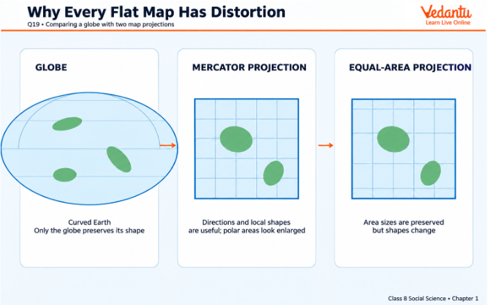
Answer: All map projections show some distortion because the Earth is an oblate spheroid, while maps are drawn on flat surfaces.
You can't show the Earth's curved surface on a flat map without changing some features.
Some maps show the correct shapes of countries but not their actual sizes.
Other maps show sizes more accurately but change the shapes.
This is why different map projections are used for different purposes.
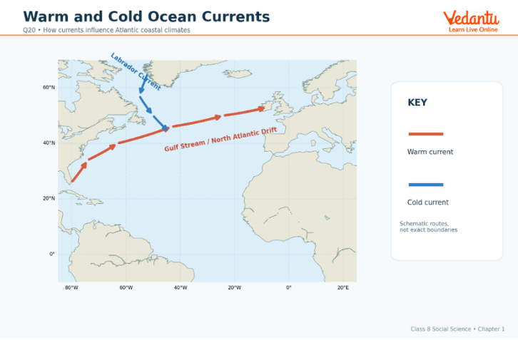
Q20. Differentiate between warm and cold ocean currents. Give an example of how ocean currents affect climate.
Answer:
Warm currents carry warm water from the Equator towards the poles.
Cold currents carry cold water from the polar regions towards the Equator.
For example, the Gulf Stream carries warm water through the Atlantic Ocean towards Western Europe. It makes places like the United Kingdom warmer than other places at similar latitudes.
Q21. How do the European Plain and its rivers support human life?
Answer: The European Plain and its rivers support human life in several ways:
The fertile soil helps farmers grow wheat, barley, rye and potatoes.
Rivers provide important routes for trade and transport.
The flat land makes it easier to build towns, cities and roads.
Natural resources such as coal, oil and natural gas support industries.
Q22. Explain how the Alps are important to Europe.
Answer: The Alps are important to Europe for several reasons:
They supply freshwater to rivers such as the Rhine and tributaries of the Danube.
River water is used for drinking, irrigation and producing hydroelectric power.
The mountains and forests provide homes for many plants and animals.
Tourists visit the Alps for skiing, hiking and sightseeing.
Q23. How have people and animals adapted to life in the Sahara Desert?
Answer: People and animals have different ways of surviving the Sahara Desert's extreme heat.
People wear traditional clothing and headgear to stay cool.
Some houses are built underground to remain cool in summer and warm in winter.
Nomadic groups rear sheep, goats and camels for their livelihood.
Fennec foxes have large ears that help release body heat.
Desert plants such as cacti store water to survive dry conditions.
Q24. Why was the River Nile important to ancient Egyptian civilisation?
Answer: The River Nile helped ancient Egyptians live and farm in a dry region.
Its water was used to grow crops such as wheat, barley and flax.
It provided drinking water and supported fishing.
It served as an important route for transport and trade.
The Nile made farming and settlements possible in areas that would otherwise have been too dry.
Q25. How does deforestation affect the Amazon Rainforest?
Answer: Deforestation affects the Amazon Rainforest in several ways:
Cutting down trees destroys the natural homes of plants and animals.
As forest cover decreases, many species are at risk of disappearing.
Indigenous communities that depend on the forest are affected.
Forest loss adds to environmental problems linked to climate change.
Protecting the rainforest helps save its plants, animals and natural resources.
Q26. How do the Great Lakes support North America, and what environmental problems do they face?
Answer: The Great Lakes are a chain of five large freshwater lakes in North America.
They provide shipping routes for trade and transport.
They supply drinking water to several cities.
They provide homes for different kinds of wildlife.
However, chemical contamination, agricultural runoff and industrial waste pollute the lakes. These problems affect water quality and harm aquatic life.
Class 8 Social Science Chapter 1 Long Answer Questions
Q27. Explain how oceans influence the Earth’s climate and support life.
Answer: Oceans cover about 71% of the Earth’s surface and contain nearly 97% of its water. They help control the climate and support many living organisms.
Control temperature: Oceans absorb heat and release it slowly, helping to control temperatures.
Bring rainfall: Water evaporates from oceans and adds moisture to the air, which helps form clouds and rainfall.
Affect coastal climate: Warm and cold ocean currents influence coastal temperatures.
Support marine life: Oceans provide homes for tiny plankton, fish, turtles, whales and many other animals.
Produce oxygen: Marine organisms such as plankton produce almost half of the oxygen we breathe.
Support trade: Oceans provide routes for ships to transport goods between countries.
Q28. Compare the Tibetan Plateau and the Colorado Plateau based on their formation, physical features and importance.
Answer:
Q29. Explain the main threats to the Great Barrier Reef and the Amazon Rainforest. Suggest ways to protect them.
Answer: The Great Barrier Reef and the Amazon Rainforest are home to many plants and animals. Both face threats from human activities.
Threats to the Great Barrier Reef:
Pollution damages corals and affects marine animals.
Overfishing reduces fish populations and harms marine life.
Climate change affects ocean conditions.
Changes in the chemical composition of ocean water, largely caused by human activity, can cause coral bleaching and habitat loss.
Threats to the Amazon Rainforest:
Deforestation destroys the natural homes of plants and animals.
Clearing forests for development reduces forest cover.
Climate change threatens the rainforest.
Indigenous communities may lose the natural resources they depend on.
Ways to protect them:
Reduce pollution in oceans and forests.
Prevent unnecessary cutting of trees.
Control overfishing and protect marine animals.
Protect endangered plants and animals.
Involve local communities in protecting natural resources.
Q30. Describe the important physical features of Australia and Antarctica. How do they support life in extreme conditions?
Answer: Australia and Antarctica have large desert regions, but their climates are very different.
Australia:
A large part of Australia is dry and forms the Great Australian Desert, which includes the Great Victoria Desert.
The deserts are home to reptiles, skinks, wallabies, bilbies and feral camels.
Predators such as dingoes, large lizards, cats, foxes and snakes also live here.
Some rare animals, including the sandhill dunnart, marsupial mole and mallee fowl, are struggling to survive.
The Spinifex are an Indigenous community that has lived in the Australian desert for over 25,000 years. Younger generations are preserving their traditional way of life and culture.
Antarctica:
Antarctica is the largest desert on Earth, covering over 14 million square kilometres.
It is a cold desert, unlike the hot deserts of Australia.
It is the coldest desert on Earth, even colder than the Arctic.
Its extremely cold conditions make it difficult for most plants and animals to survive.
Class 8 Social Science Chapter 1 Important Questions: Key Topics and Preparation Tips from Vedantu
Focus on key geographical features, their locations, formation and importance. Practise Vedantu’s Class 8 Social Science Chapter 1 important questions and answers to strengthen your understanding and prepare for exams.
Focus on these topics while studying:
Preparation Tips for Class 8 Social Science Chapter 1
Keep the Class 8 Social Science Chapter 1 important questions and answers PDF open while revising, and tick off each question after you attempt it.
Use the Class 8 Social Science Chapter 1 important questions PDF download for a final revision round before the test.
Class 8 Social Science Part 2 Chapter 1 World Geography: Some Glimpses Study Materials
Check out these study materials to improve key geographical concepts and learn more about the world around you.
Class 8 Social Science Chapter-Wise Important Questions
Additional Study Materials for Class 8 Social Science
FAQs on Important Questions for Class 8 Social Science Chapter 1: World Geography – Some Glimpses (Exploring Society: India and Beyond Part 2) | 2026–27
1. What are the most important topics in Class 8 Social Science Chapter 1?
The Class 8 Social Science Chapter 1 important questions and answers focus on oceans and ocean currents, plateaus, deserts, rainforests and human impact on nature.
2. Where can students find Class 8 Social Science Chapter 1 important questions and answers PDF?
Students can find the questions and answers on this Vedantu page, along with a PDF download option when available.
3. Why is the Tibetan Plateau called the ‘Third Pole’?
The Tibetan Plateau and its mountains hold the largest reserves of freshwater outside the polar regions. Tectonic plate collisions formed it. Q14 and Q28 in this set cover it.
4. Does the Gulf Stream make the United Kingdom warmer than other places at similar latitudes?
Yes. The Gulf Stream is a warm ocean current that carries warm water through the Atlantic Ocean towards Western Europe. This is why the United Kingdom is warmer than other places at similar latitudes. Q3 and Q20 cover this.
5. Which landforms are covered in Class 8 Social Science Chapter 1?
World Geography: Some Glimpses covers plateaus such as the Tibetan and Colorado Plateaus, the European Plain, and mountain ranges such as the Alps, the Andes and the Ural Mountains. It also covers deserts, rainforests and grasslands. Practise these with the Class 8 Social Science Chapter 1 important questions and answers before the exam.
6. Why is the Tibetan Plateau called the ‘Third Pole’?
The Tibetan Plateau and its mountains hold the largest reserves of freshwater outside the polar regions. Tectonic plate collisions formed it. Q14 and Q28 in this set cover it.
7. Which deserts are covered in this chapter?
The chapter covers the Sahara, the Atacama Desert, the Gobi Desert with its very cold winters, the deserts of Australia and Antarctica, the coldest desert on Earth. Questions focus on climate, wildlife and how people adapt to dry or freezing conditions.
8. Which environmental problems are covered in Class 8 Social Science Chapter 1?
The chapter covers deforestation in the Amazon Rainforest, coral bleaching on the Great Barrier Reef, pollution in the Great Lakes and melting permafrost. Short and long answer questions ask about the causes, effects, and ways to protect these places.