


Tibet Himalayan Ranges: Location, Rivers and Major Peaks
The Trans Himalayas Mountain Region, also known as the Tibet Himalayan Region, forms the northernmost range of the Himalayan mountain system. Located mainly in Tibet and extending into parts of India and Nepal, this region is known for its cold desert climate, high-altitude plateaus, and unique geological structure. The Trans Himalayas play a crucial role in India’s physical geography and are important for competitive exams like NEET, UPSC, and other GK-based examinations. Understanding this region helps students grasp concepts related to mountain formation, climate, biodiversity, and strategic importance.
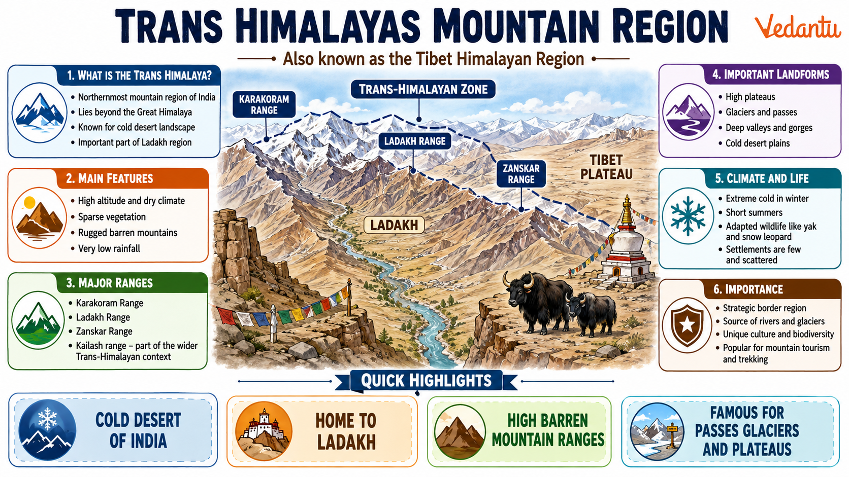
Location and Extent
The Trans Himalayas lie to the north of the Great Himalayas. They run parallel to the main Himalayan range and stretch across Tibet, India, and parts of Nepal. In India, this region mainly covers Ladakh and parts of Himachal Pradesh.
- Located north of the Great Himalayan range
- Extends from Ladakh in India to Tibet
- Forms part of the larger Himalayan mountain system
- Includes high-altitude plateaus and cold deserts
Major Mountain Ranges of the Trans Himalayas
The Trans Himalayan region consists of several important mountain ranges that run parallel to the Great Himalayas. These ranges are geologically older and differ in structure and composition.
1. Karakoram Range
- Home to K2, the second highest peak in the world
- Contains large glaciers like Siachen Glacier
- Strategically important for India
2. Ladakh Range
- Located north of the Indus River
- Composed mainly of granite rocks
- Known for barren and rocky landscapes
3. Zanskar Range
- Located south of the Ladakh Range
- Acts as a barrier between Ladakh and Kashmir Valley
- Contains several high passes
Important Ranges of the Trans Himalayas
| Range | Location | Key Feature |
|---|---|---|
| Karakoram | Ladakh and Tibet | K2 and Siachen Glacier |
| Ladakh Range | North of Indus River | Cold desert landscape |
| Zanskar Range | Between Ladakh and Kashmir | High mountain passes |
These ranges together form the Trans Himalayan mountain system and contribute significantly to the geographical and climatic features of northern India.
Climate of the Trans Himalayas
The Trans Himalayan region experiences an extreme cold desert climate. Due to its location in the rain shadow area of the Great Himalayas, it receives very little rainfall.
- Very low annual rainfall
- Extremely cold winters
- Large variation between day and night temperatures
- Sparse vegetation due to dry conditions
Rivers of the Trans Himalayan Region
Several important rivers originate in or flow through the Trans Himalayas. These rivers are mainly fed by glaciers and snowmelt.
- Indus River originates near Lake Mansarovar in Tibet
- Sutlej River also rises from the Tibetan plateau
- Rivers are perennial due to glacier melt
Flora and Fauna
Due to harsh climatic conditions, the vegetation is sparse and mainly consists of alpine shrubs and grasses. However, the region supports unique wildlife adapted to cold desert conditions.
Important Animals
- Snow leopard
- Tibetan antelope
- Yak
- Wild ass
Geological Formation
The Trans Himalayas were formed due to the collision of the Indian Plate with the Eurasian Plate. This tectonic activity led to the upliftment of mountain ranges and the formation of high-altitude plateaus. The rocks found here are mainly sedimentary and metamorphic in nature.
Strategic and Economic Importance
The Trans Himalayan region is strategically important due to its international borders with China and Pakistan. It also holds economic importance because of tourism, mountaineering, and mineral resources.
- Presence of important border areas like Ladakh
- Glaciers serve as freshwater reserves
- Tourism and adventure sports
Key Points for NEET and Competitive Exams
- Trans Himalayas lie north of the Great Himalayas
- Major ranges include Karakoram, Ladakh, and Zanskar
- Region has a cold desert climate
- Important rivers like Indus and Sutlej originate here
- Formed due to plate tectonic collision
The Trans Himalayas Mountain Region or Tibet Himalayan Region is a vital part of India’s physical geography. Its unique location, climate, and geological features make it an important topic for General Knowledge and competitive examinations. A clear understanding of its ranges, rivers, climate, and importance will help students build a strong foundation in geography.
FAQs on Trans Himalayas Mountain Region: Location, Climate and Importance
1. What is the Trans Himalayas Mountain Region?
The Trans Himalayas Mountain Region is a high-altitude mountain range located north of the Great Himalayas, mainly in Tibet and Ladakh. It is also known as the Tibetan Himalayan Region.
Key features include:
• Lies between the Great Himalayas and the Tibetan Plateau
• Includes ranges like Karakoram, Ladakh, and Zanskar
• Characterized by cold desert climate and sparse vegetation
• Important for glaciers and river sources
People also ask: Where are the Trans Himalayas located? What is the Tibetan Plateau?
2. Where are the Trans Himalayas located in India?
The Trans Himalayas in India are mainly located in Ladakh and parts of Jammu & Kashmir. They extend into Tibet (China) and neighboring regions.
Main Indian locations:
• Ladakh Plateau
• Karakoram Range
• Zanskar Range
• Near the border of China and Pakistan
This region forms part of the northernmost mountain system of India and plays a vital role in geography and defense studies.
3. Which mountain ranges are part of the Trans Himalayas?
The Trans Himalayas consist of three major mountain ranges: the Karakoram, Ladakh, and Zanskar ranges.
Important ranges include:
• Karakoram Range – Home to K2 (second highest peak in the world)
• Ladakh Range – Lies between Karakoram and Zanskar
• Zanskar Range – Separates Ladakh from Himachal Pradesh
These ranges are known for high peaks, glaciers, and rugged terrain.
4. What is the climate of the Trans Himalayas?
The Trans Himalayas have a cold desert climate with very low rainfall due to their location in the rain shadow area.
Climate characteristics:
• Extremely cold winters
• Low precipitation (less than 10 cm annually in some areas)
• Sparse vegetation
• Strong winds and dry conditions
This region is often called a Cold Desert of India, especially in Ladakh.
5. Why are the Trans Himalayas important?
The Trans Himalayas are important for geography, environment, and strategic reasons.
Main importance:
• Source of major glaciers like Siachen Glacier
• Origin of rivers such as Indus River
• Rich in mineral resources
• Strategic border region for India
People also search: Why is Ladakh important? What is the significance of Karakoram?
6. What is the difference between the Great Himalayas and Trans Himalayas?
The Great Himalayas lie south of the Trans Himalayas and are higher and more continuous, while the Trans Himalayas are older and more rugged.
Key differences:
• Location: Trans Himalayas are north of Great Himalayas
• Climate: Trans Himalayas are colder and drier
• Vegetation: Very sparse in Trans Himalayas
• Ranges: Include Karakoram and Ladakh ranges
This comparison is important for school geography and competitive exams.
7. Which rivers originate in the Trans Himalayas?
Several important rivers originate from the Trans Himalayan region, especially from glaciers and snowfields.
Major rivers:
• Indus River
• Sutlej River
• Brahmaputra (Tsangpo in Tibet)
These rivers support millions of people in India and neighboring countries.
8. What is the highest peak in the Trans Himalayas?
K2 (Mount Godwin-Austen) is the highest peak in the Trans Himalayas and the second highest peak in the world.
Key facts about K2:
• Height: 8,611 meters
• Located in the Karakoram Range
• Known as one of the most difficult mountains to climb
The Karakoram Range contains several high peaks above 8,000 meters.
9. What type of vegetation is found in the Trans Himalayas?
The Trans Himalayas have sparse vegetation due to the cold desert climate.
Common vegetation types:
• Alpine grasses
• Mosses and lichens
• Small shrubs
• Scattered thorny bushes
Wildlife includes species like the Snow Leopard, Tibetan Antelope, and Yak.
10. Why is the Trans Himalayas region called a Cold Desert?
The Trans Himalayas are called a Cold Desert because they receive very little rainfall and experience extremely cold temperatures.
Reasons include:
• Located in the rain shadow region of the Great Himalayas
• Low humidity and dry winds
• Minimal vegetation cover
• Long and harsh winters
Ladakh is often referred to as the Cold Desert of India in geography textbooks.