


Major Tributaries of the Ganga River and Their Role in the Basin
The Ganga River System is one of the most important river systems in India and plays a vital role in the country’s geography, economy, culture, and ecology. It supports millions of people through agriculture, drinking water, transportation, and religious activities. Originating in the Himalayas and flowing into the Bay of Bengal, the Ganga and its tributaries form one of the largest river basins in the world. For students and competitive exam aspirants, understanding the Ganga River System is essential in Indian Geography and General Knowledge.
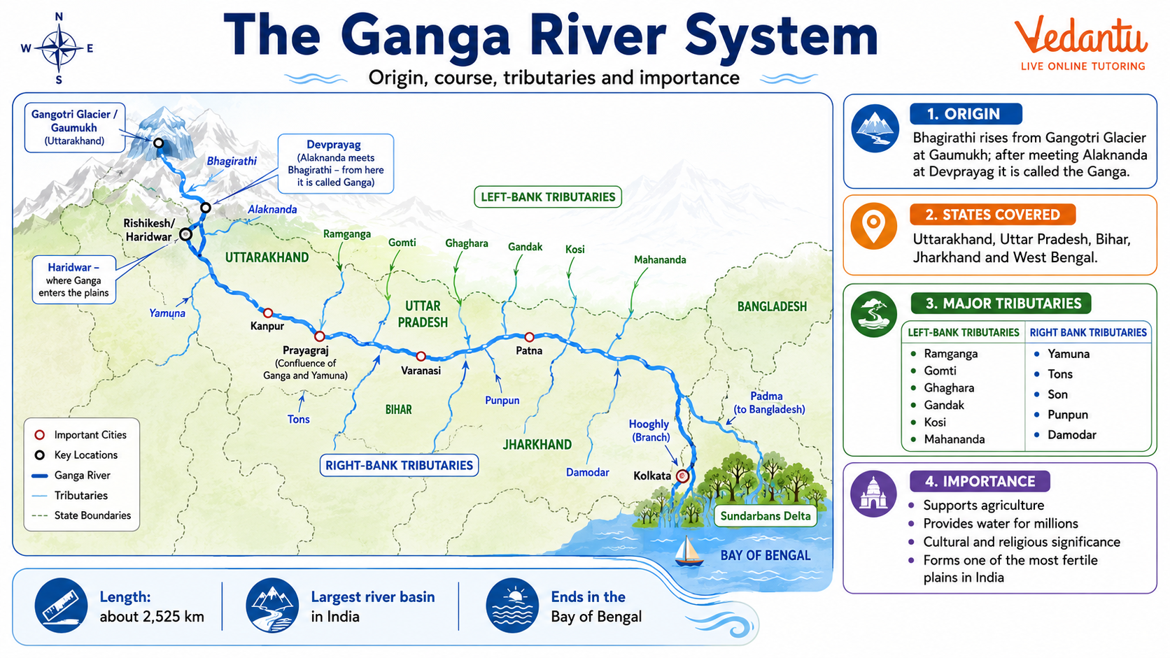
Origin and Course of the Ganga River
The Ganga originates as the Bhagirathi from the Gangotri Glacier in Uttarakhand at an elevation of about 4,100 meters. At Devprayag, the Bhagirathi meets the Alaknanda River, and from this point onwards, the river is known as the Ganga. It flows through the northern plains of India and finally drains into the Bay of Bengal.
States Through Which the Ganga Flows
- Uttarakhand
- Uttar Pradesh
- Bihar
- Jharkhand
- West Bengal
After entering West Bengal, the river divides into distributaries. One branch flows into Bangladesh as the Padma, while the other branch, known as the Hooghly, flows through West Bengal and meets the Bay of Bengal.
Major Tributaries of the Ganga
The Ganga River System is formed by numerous tributaries that join it from both the left and right banks. These tributaries significantly increase its water volume and drainage area.
Left Bank Tributaries
- Ramganga
- Gomti
- Ghaghara
- Gandak
- Kosi
Right Bank Tributaries
- Yamuna
- Tons
- Son
- Punpun
Among these, the Yamuna is the largest and most important tributary of the Ganga. It joins the Ganga at Prayagraj, forming the famous Triveni Sangam.
Key Facts About the Ganga River System
| Feature | Details | Importance |
|---|---|---|
| Origin | Gangotri Glacier, Uttarakhand | Himalayan river system |
| Total Length | About 2,525 km | One of the longest rivers in India |
| Mouth | Bay of Bengal | Forms Sundarbans Delta |
The Ganga-Brahmaputra Delta, also known as the Sundarbans Delta, is the largest delta in the world. It is famous for its mangrove forests and the Royal Bengal Tiger.
Physiographic Divisions of the Ganga Basin
The Ganga River System can be divided into three main courses based on its flow and physical features.
- Upper Course: From the source to Haridwar. The river flows rapidly through deep gorges and valleys in the Himalayas.
- Middle Course: From Haridwar to Varanasi. The river enters the northern plains and forms meanders, oxbow lakes, and floodplains.
- Lower Course: From Varanasi to the Bay of Bengal. The river becomes slow-moving and forms a large delta.
Economic Importance of the Ganga River System
- Provides irrigation to the fertile Indo-Gangetic plains.
- Supports agriculture such as rice, wheat, sugarcane, and jute.
- Supplies drinking water to millions of people.
- Facilitates inland water transport.
- Supports fishing and other livelihood activities.
Cultural and Religious Significance
The Ganga is considered a sacred river in Hinduism. Major religious cities such as Haridwar, Rishikesh, Prayagraj, Varanasi, and Kolkata are located along its banks. Rituals, festivals, and pilgrimages are closely associated with the river. The Kumbh Mela, one of the largest religious gatherings in the world, is held at Prayagraj on the banks of the Ganga.
Environmental Issues and Conservation
Despite its importance, the Ganga faces serious environmental challenges due to pollution, industrial waste, sewage discharge, and overuse of water. Conservation efforts have been initiated by the government to restore and protect the river.
Major Conservation Initiatives
- Ganga Action Plan
- Namami Gange Programme
- Establishment of sewage treatment plants
- Public awareness campaigns
Important Points for Competitive Exams
- The Ganga is a perennial river fed by glaciers and rainfall.
- The Yamuna is its largest tributary.
- The Sundarbans Delta is the largest delta in the world.
- The river basin is one of the most densely populated regions in the world.
Conclusion
The Ganga River System is not only a major geographical feature of India but also a lifeline for millions of people. It shapes the physical landscape, supports agriculture and industries, and holds deep cultural and spiritual significance. Understanding its origin, tributaries, course, and importance is essential for students preparing for school exams, competitive exams, and general awareness tests. A clear knowledge of the Ganga River System helps in building a strong foundation in Indian Geography and General Knowledge.
FAQs on The Ganga River Network: Origin, Tributaries and Importance
1. What is the Ganga River System?
The Ganga River System is the largest river system in India, draining the northern plains and supporting millions of people. It includes:
• The Ganga River and its major tributaries like Yamuna, Ghaghara, Gandak, and Kosi
• Origin from the Gangotri Glacier in Uttarakhand
• A vast drainage basin covering India, Nepal, and Bangladesh
This river system is vital for agriculture, irrigation, transportation, and religious activities.
2. Where does the Ganga River originate and end?
The Ganga River originates from the Gangotri Glacier in the Himalayas and drains into the Bay of Bengal. Key points include:
• Source: Gaumukh (Bhagirathi River) in Uttarakhand
• Confluence with Alaknanda at Devprayag, where it is called Ganga
• Forms the Sundarbans Delta before entering the Bay of Bengal
This origin and mouth are common GK and competitive exam questions.
3. What are the major tributaries of the Ganga River?
The major tributaries of the Ganga River are classified into left-bank and right-bank tributaries. Important tributaries include:
• Left-bank: Gomti, Ghaghara, Gandak, Kosi
• Right-bank: Yamuna, Son, Chambal
Among them, the Yamuna River is the largest tributary, joining at Prayagraj (Allahabad).
4. Why is the Ganga River considered sacred in India?
The Ganga River is considered sacred because it holds immense religious and cultural significance in Hinduism. Key reasons include:
• Believed to be the river of the goddess Ganga
• Used for holy baths, rituals, and cremation ceremonies
• Important pilgrimage cities like Haridwar, Varanasi, and Prayagraj
It is often called the “lifeline of India” and symbolizes purity and salvation.
5. What is the length and basin area of the Ganga River?
The Ganga River is about 2,525 km long and has one of the largest river basins in Asia. Important facts:
• Length: Approximately 2,525 kilometers
• Basin area: Around 8.6 lakh square kilometers
• Supports nearly 40% of India’s population
This makes it one of the most significant rivers in South Asia.
6. What is the importance of the Ganga River System for agriculture?
The Ganga River System is crucial for agriculture because it creates fertile alluvial plains. Its importance includes:
• Deposition of alluvial soil ideal for crops
• Irrigation for wheat, rice, sugarcane, and pulses
• Supports the Indo-Gangetic Plain, one of the most fertile regions in the world
This makes it central to India’s food security.
7. What is the Sundarbans Delta?
The Sundarbans Delta is the world’s largest river delta, formed by the Ganga and Brahmaputra rivers. Key features:
• Located in India and Bangladesh
• Covered with mangrove forests
• Habitat of the Royal Bengal Tiger
It is a UNESCO World Heritage Site and an important biodiversity hotspot.
8. What are the environmental issues facing the Ganga River?
The Ganga River faces serious environmental challenges due to pollution and overuse. Major issues include:
• Industrial waste and sewage discharge
• Religious offerings and plastic waste
• Decline in aquatic biodiversity
The government launched the Namami Gange Programme to clean and conserve the river.
9. Which states does the Ganga River flow through?
The Ganga River flows through several Indian states before entering Bangladesh. These include:
• Uttarakhand
• Uttar Pradesh
• Bihar
• Jharkhand
• West Bengal
This wide coverage makes it economically and culturally significant across northern India.
10. Why is the Ganga River System important for competitive exams?
The Ganga River System is important for competitive exams because it is frequently asked in Geography and GK sections. Exam-relevant topics include:
• Source, tributaries, and length
• Important cities and confluences like Devprayag and Prayagraj
• Sundarbans Delta and environmental issues
Questions related to the Indo-Gangetic Plain and irrigation are common in UPSC, SSC, and state exams.