


Who Was the First Cartographer of India and Why Is He Important?
The First Map Creator of India is widely recognized as James Rennell, a British geographer, historian, and cartographer who played a pioneering role in scientifically mapping the Indian subcontinent during the 18th century. He is often referred to as the "Father of Indian Geography" because he prepared the first detailed and accurate maps of India based on systematic surveys. His work laid the foundation for modern cartography in India and significantly improved geographical knowledge during the British East India Company period.
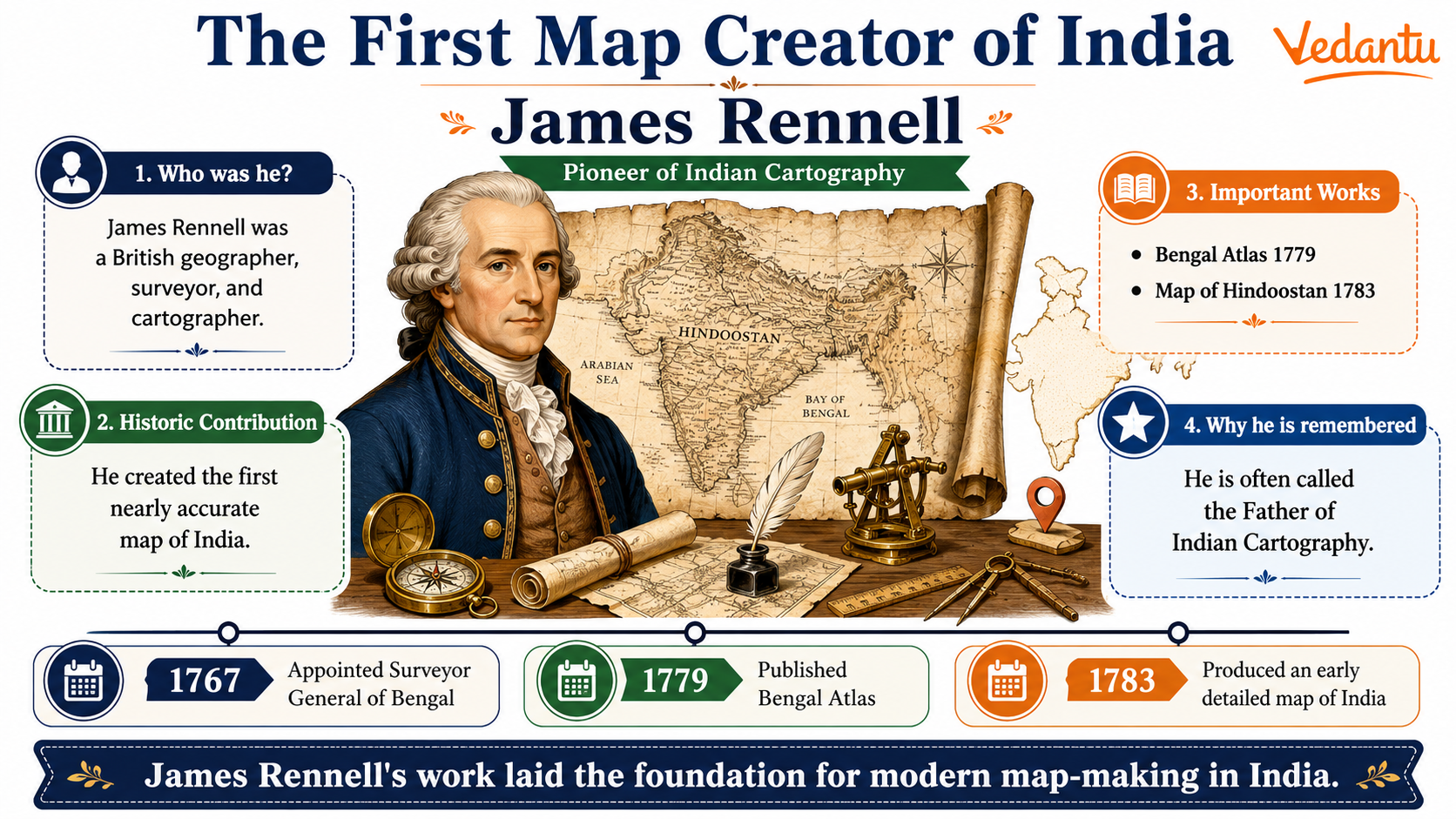
Who Was James Rennell?
James Rennell was born in 1742 in England. He joined the British Royal Navy at a young age and later worked with the British East India Company. Due to his expertise in surveying and mapping, he was appointed as the Surveyor General of Bengal in 1767. His efforts in mapping Indian territories earned him historical importance in Indian geography.
- Born - 1742, England
- Profession - Geographer and Cartographer
- Appointed Surveyor General of Bengal - 1767
- Title - Father of Indian Geography
- Died - 1830
Major Contributions of James Rennell
James Rennell made several important contributions to the field of geography and cartography in India. His surveys helped in administrative control, military planning, and trade expansion for the British East India Company.
1. First Scientific Map of India
Rennell prepared one of the earliest accurate maps of India based on actual field surveys rather than guesswork. His maps included rivers, mountains, cities, and trade routes with improved precision.
2. Map of Bengal
He created a detailed map of Bengal in 1779. This map became extremely important for revenue collection and administration.
3. Bengal Atlas
The Bengal Atlas, published in 1779, contained several maps of eastern India. It is considered one of his most significant works.
4. Memoir of a Map of Hindoostan
In 1783, Rennell published "Memoir of a Map of Hindoostan," which explained the geographical features of India in detail. It became a reference book for scholars and administrators.
Key Facts About the First Map Creator of India
| Name | Year of Major Work | Significance |
|---|---|---|
| James Rennell | 1779 | Created detailed map of Bengal |
| James Rennell | 1783 | Published Memoir of a Map of Hindoostan |
The table above highlights the most important milestones in Rennell's career as India's first scientific map creator. His works became the base for later surveys including the Great Trigonometrical Survey of India.
Why James Rennell Is Called the Father of Indian Geography
James Rennell earned this title because he was the first to apply systematic surveying methods in India. Before his efforts, maps of India were largely inaccurate and incomplete. His scientific approach included measuring distances, studying river systems, and documenting regional boundaries.
- Introduced modern surveying techniques in India
- Improved geographical accuracy
- Helped in administrative and military planning
- Provided base data for future surveys
Importance in General Knowledge and Competitive Exams
The First Map Creator of India is an important topic in General Knowledge. Questions related to James Rennell frequently appear in competitive exams such as UPSC, SSC, State PCS, Railway exams, and other government recruitment tests.
Common Exam Questions
- Who is known as the Father of Indian Geography?
- Who prepared the first scientific map of India?
- When was the Bengal Atlas published?
- Who was appointed as the first Surveyor General of Bengal?
Conclusion
James Rennell is recognized as the First Map Creator of India due to his groundbreaking work in cartography during the 18th century. His maps brought accuracy and scientific methods to Indian geography. As the Father of Indian Geography, his contributions laid the foundation for modern mapping and surveying in India. Understanding his work is essential for students preparing for competitive exams and for anyone interested in the historical development of geography in India.
FAQs on The First Map Creator of India and His Contribution to Indian Mapping
1. Who was the first map creator of India?
The first scientific map creator of India was James Rennell, known as the Father of Indian Cartography.
- He was a British geographer and surveyor in the 18th century.
- He prepared the first accurate maps of Bengal, Bihar, and parts of India.
- His major work, “Bengal Atlas” (1779), laid the foundation of modern Indian mapping.
- He also published “Memoir of a Map of Hindoostan”, improving geographical knowledge of India.
2. Why is James Rennell called the Father of Indian Cartography?
James Rennell is called the Father of Indian Cartography because he created the first detailed and scientific maps of India.
- Conducted systematic land surveys under the British East India Company.
- Produced accurate geographical data of rivers, boundaries, and regions.
- Standardized modern map-making techniques in India.
- His work became the base for later surveys like the Great Trigonometrical Survey.
3. What is the Bengal Atlas?
The Bengal Atlas is a collection of detailed maps prepared by James Rennell in 1779.
- It covered regions of Bengal and Bihar.
- Included information on rivers, districts, and settlements.
- Helped the British administration in revenue collection and governance.
- Marked a major milestone in the history of cartography in India.
4. When was the first scientific mapping of India done?
The first scientific mapping of India began in the 1760s–1770s under James Rennell.
- Conducted during the rule of the British East India Company.
- Focused initially on Bengal Presidency.
- Used systematic surveying and measurement techniques.
- Later expanded through the Great Trigonometrical Survey (1802).
5. What was the Great Trigonometrical Survey of India?
The Great Trigonometrical Survey (GTS) was a major project to measure and map the entire Indian subcontinent accurately.
- Started in 1802 by the British.
- Led by surveyors like William Lambton and George Everest.
- Used advanced triangulation methods.
- Helped measure Mount Everest and other Himalayan peaks.
6. How did James Rennell contribute to geography?
James Rennell significantly advanced geography and cartography in India through accurate mapping and documentation.
- Mapped major Indian rivers like the Ganga and Brahmaputra.
- Corrected earlier geographical errors about India.
- Published influential geographical works in Europe.
- Improved global understanding of Indian topography and boundaries.
7. Why was map-making important during British rule in India?
Map-making was important during British rule for administration, taxation, and military control.
- Helped in revenue settlement and land records.
- Assisted in military planning and expansion.
- Improved transportation and trade routes.
- Strengthened British governance through accurate territorial mapping.
8. Were there maps of India before James Rennell?
Yes, maps of India existed before James Rennell, but they were less accurate and not scientifically surveyed.
- Ancient Indian texts contained geographical descriptions.
- Greek and Arab travelers created early maps of Hindustan.
- Mughal records had regional maps.
- Rennell’s work was the first systematic and scientific survey-based mapping.
9. Which book did James Rennell write about India?
James Rennell wrote “Memoir of a Map of Hindoostan”, a detailed geographical account of India.
- Published in the late 18th century.
- Explained the physical and political features of India.
- Included revised and improved maps.
- Became an important reference in historical geography and cartography.
10. What is the significance of cartography in Indian history?
Cartography played a crucial role in shaping India’s administrative, political, and geographical identity.
- Helped define territorial boundaries.
- Supported infrastructure like railways and roads.
- Assisted in scientific research and exploration.
- Contributed to modern institutions like the Survey of India, which continues mapping today.