


Main Ocean Floor Topography Types and Their Importance
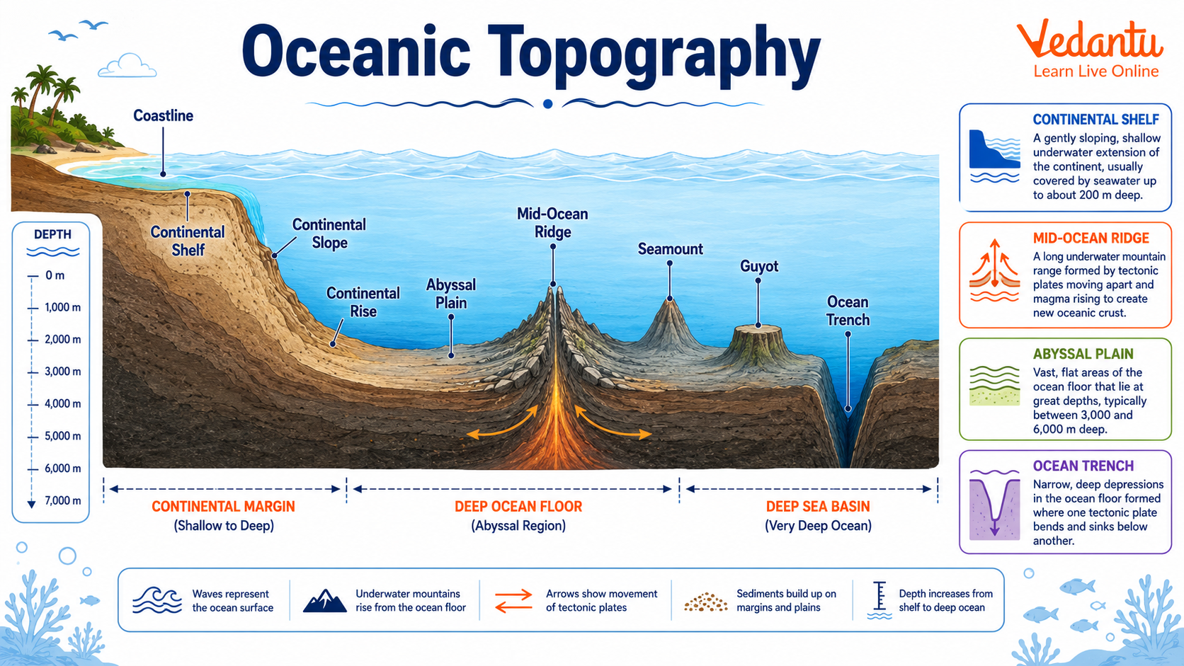
Oceanic topography refers to the diverse landforms found on the floor of the oceans. These underwater features are shaped by tectonic movements, volcanic activity, sediment deposition, and erosional processes over millions of years. The study of oceanic topography helps in understanding plate tectonics, marine ecosystems, earthquake zones, and mineral resources. Oceanic Topography Typology and Significance is an important topic in geography and earth sciences, especially for students preparing for competitive examinations and those interested in physical geography.
Meaning of Oceanic Topography
Oceanic topography describes the physical features and relief of the ocean floor. Just like continents have mountains, plains, and valleys, the ocean floor also has varied landforms. These features are collectively known as submarine relief. Modern technologies such as sonar mapping and satellite altimetry have helped scientists map these underwater structures in detail.
Typology of Oceanic Topography
The ocean floor is broadly divided into three major zones based on depth and distance from the coast. Each zone contains distinct landforms formed due to specific geological processes.
1. Continental Margin
The continental margin is the submerged extension of the continent. It forms the transition between continental and oceanic crust.
- Continental Shelf - The gently sloping submerged edge of a continent. It is rich in marine life and mineral resources.
- Continental Slope - The steep slope connecting the shelf to the deep ocean basin.
- Continental Rise - A gentle incline formed by the accumulation of sediments at the base of the slope.
2. Deep Ocean Basin
The deep ocean basin covers the largest part of the ocean floor and lies beyond the continental margin.
- Abyssal Plains - Extremely flat and deep areas covered with fine sediments.
- Oceanic Trenches - Deep and narrow depressions formed at convergent plate boundaries.
- Seamounts - Submerged volcanic mountains rising from the ocean floor.
- Guyots - Flat topped seamounts formed due to erosion.
3. Mid Oceanic Ridges
Mid oceanic ridges are long underwater mountain chains formed at divergent plate boundaries. They are sites of sea floor spreading where new oceanic crust is created. These ridges often have a central rift valley and are associated with volcanic activity and earthquakes.
Major Oceanic Topographic Features
| Feature | Location | Significance |
|---|---|---|
| Continental Shelf | Near continents | Fishing and petroleum resources |
| Mid Ocean Ridge | Ocean basins | Sea floor spreading and volcanism |
| Oceanic Trench | Convergent boundaries | Deepest parts and earthquake zones |
These features are closely related to the theory of plate tectonics. Their study provides insight into the dynamic nature of the Earth's crust and helps in understanding natural hazards and marine resources.
Processes Shaping Oceanic Topography
Oceanic landforms are shaped by various geological and physical processes operating over geological time.
- Plate Tectonics - Movement of lithospheric plates leads to formation of ridges, trenches, and volcanic islands.
- Volcanic Activity - Submarine eruptions create seamounts and islands.
- Sedimentation - Deposition of sediments forms continental rise and abyssal plains.
- Erosion and Subsidence - Modify the shape of underwater mountains and plateaus.
Significance of Oceanic Topography
Oceanic topography plays a vital role in environmental, economic, and geological contexts. Its importance extends beyond academic study.
- Understanding Plate Tectonics - Helps explain continental drift, earthquakes, and volcanic activity.
- Resource Exploration - Continental shelves contain oil, natural gas, and mineral deposits.
- Marine Biodiversity - Different depths and features support diverse ecosystems.
- Climate Regulation - Ocean basins influence ocean currents and global climate patterns.
- Disaster Management - Trenches and ridges are associated with earthquakes and tsunamis.
Importance for Competitive Examinations
Oceanic Topography Typology and Significance is frequently asked in geography sections of competitive examinations. Students should focus on classification of oceanic relief, formation processes, and their relationship with plate tectonics. Diagrams of continental margins and mid oceanic ridges are commonly tested. Conceptual clarity and ability to explain formation mechanisms are essential for scoring well.
Conclusion
Oceanic topography reveals that the ocean floor is not a flat and featureless surface but a dynamic landscape shaped by powerful geological forces. The typology of oceanic features such as continental margins, abyssal plains, mid oceanic ridges, and trenches reflects the active processes operating within the Earth. Understanding their significance helps in resource management, disaster preparedness, and scientific advancement. A thorough study of this topic builds a strong foundation in physical geography and earth sciences.
FAQs on Oceanic Topography: Classification and Role in Earth’s Systems
1. What is Oceanic Topography?
Oceanic Topography refers to the study and mapping of the physical features of the ocean floor. It explains the shape, structure, and relief of underwater landforms.
- Includes features like continental shelves, mid-ocean ridges, abyssal plains, trenches, and seamounts
- Studied under marine geography and oceanography
- Helps understand plate tectonics, marine ecosystems, and ocean circulation
- Also known as submarine relief or bathymetry (People Also Ask: What is bathymetry?)
2. What are the main types of Oceanic Topography?
Oceanic topography is classified into three major divisions based on depth and structure.
- Continental Margin – Continental shelf, slope, and rise
- Deep Ocean Basin – Abyssal plains and ocean deeps
- Mid-Oceanic Ridge System – Underwater mountain chains formed by tectonic activity
These categories help in understanding marine landforms and ocean floor classification (People Also Search: Types of ocean floor features).
3. What is a Continental Shelf and why is it important?
The continental shelf is the shallow, gently sloping part of the ocean floor near continents. It is economically and ecologically significant.
- Rich in marine resources like fish and petroleum
- Depth usually up to 200 meters
- Supports major fishing industries
- Important for offshore drilling and trade routes
It plays a key role in economic geography and coastal development.
4. What are Mid-Ocean Ridges?
Mid-Ocean Ridges are underwater mountain ranges formed due to divergent plate boundaries. They are the longest mountain chains on Earth.
- Created by seafloor spreading
- Example: Mid-Atlantic Ridge
- Associated with volcanic activity and earthquakes
- Crucial to the theory of Plate Tectonics
They help explain how new oceanic crust is formed (People Also Ask: How is oceanic crust formed?).
5. What are Ocean Trenches?
Ocean trenches are deep, narrow depressions in the ocean floor formed by subduction zones. They are the deepest parts of the oceans.
- Formed when one tectonic plate moves under another
- Example: Mariana Trench (deepest point on Earth)
- Associated with earthquakes and volcanic arcs
- Located mainly along the Pacific Ring of Fire
They are key to understanding tectonic movements and deep-sea geology.
6. What are Abyssal Plains?
Abyssal plains are vast, flat areas of the deep ocean floor. They are among the flattest regions on Earth.
- Found at depths of 3,000–6,000 meters
- Covered with fine sediments
- Located between continental margins and mid-ocean ridges
- Important for studying deep-sea ecosystems
They form a major part of the deep ocean basin.
7. What is the significance of Oceanic Topography?
Oceanic topography is significant because it influences climate, marine life, and tectonic activity. It plays a major role in Earth system processes.
- Controls ocean currents and global climate patterns
- Supports biodiversity and marine habitats
- Helps locate mineral and energy resources
- Explains earthquake and volcanic zones
It is vital for geography, environmental studies, and competitive exams.
8. How is Oceanic Topography mapped?
Oceanic topography is mapped using advanced technologies like sonar and satellite imaging. These methods measure ocean depth and surface variations.
- Echo sounding (SONAR) for depth measurement
- Satellite altimetry to detect gravitational variations
- Submersibles and remote-operated vehicles (ROVs)
- Creation of bathymetric maps
This process is known as bathymetric surveying (People Also Search: How do scientists map the ocean floor?).
9. What are Seamounts and Guyots?
Seamounts are underwater volcanic mountains, while guyots are flat-topped submerged volcanoes. Both are important oceanic landforms.
- Formed by volcanic activity
- Seamounts may rise above the sea surface as islands
- Guyots have flattened tops due to erosion
- Provide habitats for marine species
They contribute to understanding submarine volcanism and ocean floor relief.
10. How does Oceanic Topography relate to Plate Tectonics?
Oceanic topography is directly shaped by plate tectonic movements. Most underwater features result from plate interactions.
- Divergent boundaries form mid-ocean ridges
- Convergent boundaries create ocean trenches
- Transform boundaries cause faults and earthquakes
- Drives seafloor spreading and crust formation
This relationship explains the dynamic nature of the Earth’s lithosphere and ocean basin evolution.