


Why was the McMahon boundary line drawn in 1914 and why is it disputed?
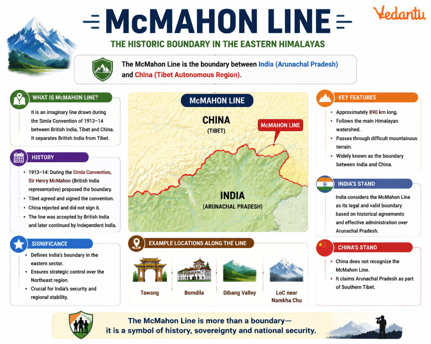
The McMahon Line is a significant boundary line between India and China, marking the border between India’s Arunachal Pradesh and China’s Tibet Autonomous Region. It was drawn during the Simla Convention of 1914 between British India and Tibet. The line remains a major point of dispute between India and China and has played an important role in shaping modern India-China relations, especially during the 1962 Sino-Indian War. Understanding the McMahon Line is essential for students preparing for competitive exams and for anyone interested in India’s geopolitical and historical developments.
Historical Background of the McMahon Line
The McMahon Line was proposed during the Simla Conference held in 1913 to 1914. The conference involved representatives of British India, Tibet, and China. The main objective was to settle the boundary between Tibet and British India and to define Tibet’s status.
- The line was named after Sir Henry McMahon, the then Foreign Secretary of British India.
- It was agreed upon by British India and Tibet in 1914.
- China did not accept the agreement and refused to sign the final convention.
- Despite China’s objection, British India considered the line as the official boundary.
Geographical Extent of the McMahon Line
The McMahon Line stretches for approximately 890 kilometers along the eastern Himalayas. It runs from the eastern border of Bhutan to the Diphu Pass near the India-Myanmar-China trijunction.
- It primarily separates Arunachal Pradesh in India from Tibet in China.
- The boundary follows the Himalayan watershed principle.
- The terrain includes high mountains, deep valleys, and dense forests.
Simla Convention 1914
The Simla Convention was the agreement under which the McMahon Line was drawn. The conference aimed to define the boundaries of Tibet and regulate relations between Tibet, China, and British India.
Key Features of the Simla Convention
- Division of Tibet into Outer Tibet and Inner Tibet.
- Recognition of Chinese suzerainty over Tibet but with autonomy for Outer Tibet.
- Demarcation of the boundary between British India and Tibet through the McMahon Line.
China rejected the convention, arguing that Tibet did not have the authority to sign international agreements independently.
Key Facts About the McMahon Line
| Aspect | Details | Year |
|---|---|---|
| Proposed By | Sir Henry McMahon | 1914 |
| Agreement | Simla Convention | 1914 |
| Length | Approximately 890 km | Not Applicable |
The table above highlights the essential information related to the origin, agreement, and geographical length of the McMahon Line, which is frequently asked in competitive examinations.
Dispute Between India and China
The McMahon Line is one of the major disputed boundaries between India and China. After India’s independence in 1947, India recognized the McMahon Line as its official border. However, China does not accept it and claims parts of Arunachal Pradesh as South Tibet.
1962 Sino-Indian War
The boundary dispute over the McMahon Line was one of the key reasons for the 1962 war between India and China. Chinese forces crossed the McMahon Line and advanced into Indian territory. After a brief but intense conflict, China declared a unilateral ceasefire and withdrew to positions north of the line.
- India considers Arunachal Pradesh an integral part of its territory.
- China refers to Arunachal Pradesh as South Tibet.
- The dispute continues to affect diplomatic relations.
Importance of the McMahon Line
The McMahon Line is strategically, politically, and geographically significant. It lies in a sensitive Himalayan region that has military and security importance for both countries.
- Strategic Importance: Controls access to key mountain passes and high-altitude terrain.
- Political Importance: Central issue in India-China diplomatic talks.
- Security Importance: Presence of military infrastructure and border management mechanisms.
Difference Between McMahon Line and Line of Actual Control
Students often confuse the McMahon Line with the Line of Actual Control (LAC). While both relate to India-China borders, they are not the same.
McMahon Line vs Line of Actual Control
| Feature | McMahon Line | Line of Actual Control |
|---|---|---|
| Origin | Simla Convention 1914 | Post 1962 War Concept |
| Recognition | Accepted by India, rejected by China | De facto boundary |
| Location | Eastern Sector | Western, Middle and Eastern Sectors |
The McMahon Line specifically refers to the eastern sector boundary, while the Line of Actual Control represents the current military control line across different sectors of the India-China border.
Conclusion
The McMahon Line is a historically significant and geopolitically sensitive boundary between India and China. Originating from the 1914 Simla Convention, it remains a central issue in bilateral relations. The line has shaped diplomatic negotiations, military strategies, and regional politics for more than a century. For students and competitive exam aspirants, understanding its origin, geographical extent, and role in the 1962 war is essential for mastering modern Indian history and international relations topics.
FAQs on McMahon Line and the India–China Border Dispute Explained
1. What is the McMahon Line?
The McMahon Line is the boundary line between India and China in the eastern sector, mainly between Arunachal Pradesh and Tibet.
- Proposed during the Simla Convention (1914)
- Named after Sir Henry McMahon, the British Indian foreign secretary
- Forms part of the eastern sector of the India-China border dispute
- China does not officially recognize this boundary
2. When was the McMahon Line created?
The McMahon Line was created in 1914 during the Simla Convention between British India and Tibet.
- Agreement signed on July 3, 1914
- Negotiated by Sir Henry McMahon
- China participated in talks but did not accept the final agreement
3. Why is the McMahon Line controversial?
The McMahon Line is controversial because China does not recognize it as a legal boundary.
- China argues Tibet had no authority to sign treaties independently
- India considers it a legitimate international boundary
- The dispute led to the 1962 Sino-Indian War
4. Who was Sir Henry McMahon?
Sir Henry McMahon was a British diplomat who proposed the McMahon Line in 1914.
- Served as Foreign Secretary of British India
- Represented British India at the Simla Conference
- Drew the boundary between Tibet and British India
5. What was the Simla Convention of 1914?
The Simla Convention (1914) was a tripartite conference between British India, Tibet, and China to settle border issues.
- Held in Shimla (Simla)
- Resulted in the drawing of the McMahon Line
- China refused to ratify the agreement
6. Which Indian state lies south of the McMahon Line?
Arunachal Pradesh lies south of the McMahon Line and is administered by India.
- China refers to it as South Tibet
- It is part of India’s Northeast region
- Key areas include Tawang, which is strategically important
7. How long is the McMahon Line?
The McMahon Line is approximately 890 kilometers long.
- Extends from Bhutan’s eastern border to the India-Myanmar-China trijunction
- Follows Himalayan mountain ranges
- Forms the eastern part of the disputed India-China border
8. What happened along the McMahon Line during the 1962 war?
During the 1962 Sino-Indian War, heavy fighting occurred along the McMahon Line.
- Chinese forces crossed the McMahon Line into Arunachal Pradesh
- Major battles occurred in Tawang and nearby areas
- China later declared a unilateral ceasefire
9. What is the difference between the McMahon Line and the Line of Actual Control (LAC)?
The McMahon Line is a proposed boundary from 1914, while the Line of Actual Control (LAC) is the present-day military control line.
- McMahon Line: Historical boundary from the Simla Convention
- LAC: Current de facto border after the 1962 war
- The two do not always exactly overlap
10. Why is the McMahon Line important for competitive exams?
The McMahon Line is important for competitive exams because it is a key topic in Indian geography and international relations.
- Frequently asked in UPSC, SSC, CDS, and State PSC exams
- Linked to the 1962 Sino-Indian War
- Important in discussions on India-China border dispute and Arunachal Pradesh