


Uttar Pradesh's Largest Districts by Area and Population Explained
Uttar Pradesh is the most populous state of India and one of the largest in terms of area. It is divided into 75 districts for administrative convenience. Among these, some districts stand out because of their large geographical area. The large districts of Uttar Pradesh are important from administrative, geographical, economic, and competitive exam perspectives. Questions related to area, population, and district headquarters are frequently asked in state-level exams such as UPPSC, UPSSSC, SSC, Railways, and other competitive examinations.
Overview of Large Districts of Uttar Pradesh
A large district is generally defined based on its geographical area in square kilometers. Larger districts usually have diverse physical features such as plains, forests, rivers, and plateaus. They may also have significant agricultural land, mineral resources, and cultural heritage. Understanding the largest districts helps students analyze regional development, administrative challenges, and resource distribution within the state.
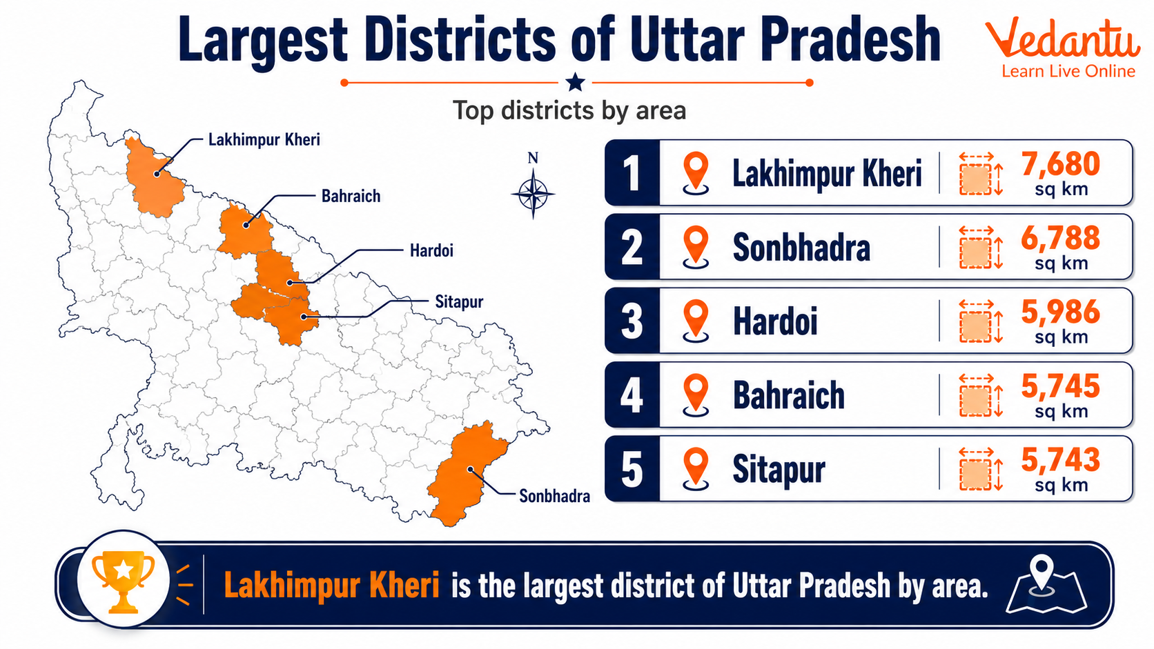
Top Large Districts of Uttar Pradesh by Area
| District | Area in sq km (Approx.) | Headquarters |
|---|---|---|
| Lakhimpur Kheri | 7,680 | Lakhimpur |
| Sonbhadra | 6,905 | Robertsganj |
| Hardoi | 5,986 | Hardoi |
| Sitapur | 5,743 | Sitapur |
| Bahraich | 5,745 | Bahraich |
Lakhimpur Kheri is the largest district of Uttar Pradesh by area. It is located in the Terai region near the Indo-Nepal border. Sonbhadra, often called the energy capital of Uttar Pradesh, is the second largest district and is rich in minerals and power projects.
Details of Major Large Districts
1. Lakhimpur Kheri
Lakhimpur Kheri is the largest district in Uttar Pradesh. It is known for its dense forests, sugarcane production, and Dudhwa National Park. The district shares an international boundary with Nepal.
- Region - Terai belt
- Major river - Sharda River
- Famous for - Dudhwa National Park and sugar industry
2. Sonbhadra
Sonbhadra is located in the southeastern part of the state. It is unique because it shares borders with four states - Madhya Pradesh, Chhattisgarh, Jharkhand, and Bihar.
- Known as - Energy capital of Uttar Pradesh
- Major projects - Rihand Dam and thermal power plants
- Rich in minerals like coal and limestone
3. Hardoi
Hardoi is one of the largest districts located in central Uttar Pradesh. Agriculture is the main occupation, and it has fertile alluvial soil.
- Major crops - Wheat, rice, and sugarcane
- Located between the Ganga and Gomti rivers
4. Sitapur
Sitapur lies in the Awadh region of Uttar Pradesh. It is known for agriculture and historical temples.
- Major river - Gomti
- Famous religious site - Naimisharanya
5. Bahraich
Bahraich is situated near the Indo-Nepal border and has a mix of plains and forest areas. It plays an important role in agriculture and cross-border trade.
- Part of the Terai region
- Close to Katarniaghat Wildlife Sanctuary
Why Large Districts Are Important
Large districts play a significant role in the development of the state. Due to their size, they often have diverse resources and varied geographical features. However, managing a large district also presents administrative challenges.
- Better resource availability including forests, minerals, and agricultural land
- Greater administrative responsibility
- Important for regional planning and infrastructure development
- Frequently asked in competitive examinations
Exam Preparation Tips
Questions about the largest districts of Uttar Pradesh are commonly asked in state-level competitive exams. Students should remember district names in order of area and their headquarters.
- Memorize the top five largest districts by area
- Know the headquarters of each major district
- Understand important rivers, national parks, and industries in these districts
- Revise using maps for better geographical understanding
Conclusion
The large districts of Uttar Pradesh such as Lakhimpur Kheri, Sonbhadra, Hardoi, Sitapur, and Bahraich are significant due to their vast area, natural resources, and administrative importance. Knowledge of these districts is essential for general awareness and competitive examinations. A clear understanding of their location, area, headquarters, and special features helps students build a strong foundation in Uttar Pradesh General Knowledge.
FAQs on Large Districts of Uttar Pradesh Ranked by Area and Population
1. Which is the largest district of Uttar Pradesh by area?
Lakhimpur Kheri is the largest district of Uttar Pradesh by area.
• Total Area: About 7,680 sq. km
• Located in the Terai region near the Nepal border
• Known for Dudhwa National Park and rich biodiversity
• Important for agriculture, especially sugarcane farming
This district is frequently asked in GK questions related to largest districts of UP and UP geography.
2. Which is the largest district of Uttar Pradesh by population?
Prayagraj (Allahabad) is the most populous district of Uttar Pradesh.
• Population: Over 5 million (Census 2011)
• Famous for the Triveni Sangam
• Hosts the world-famous Kumbh Mela
• Major educational and administrative center
This district is important for competitive exams covering UP population statistics and demographic data.
3. Which district of Uttar Pradesh has the highest population density?
Ghaziabad has the highest population density in Uttar Pradesh.
• Located in the National Capital Region (NCR)
• Highly urbanized and industrialized
• Close to Delhi, boosting migration and growth
• Important hub for real estate and manufacturing
It is commonly searched under densely populated districts of UP and urban development topics.
4. How many districts are there in Uttar Pradesh?
Uttar Pradesh currently has 75 districts.
• It is the most populous state in India
• Divided into 18 administrative divisions
• District administration is headed by a District Magistrate (DM)
This question is important for GK exams covering UP administrative structure and state governance.
5. Which are the top 5 largest districts of Uttar Pradesh by area?
The top 5 largest districts of Uttar Pradesh by area are:
• Lakhimpur Kheri
• Sonbhadra
• Hardoi
• Sitapur
• Bahraich
These districts are significant in terms of geographical size, forest cover, and agricultural land, often asked in UPSC, SSC, and state PSC exams.
6. Which district of Uttar Pradesh is the smallest by area?
Sant Ravidas Nagar (Bhadohi) is the smallest district of Uttar Pradesh by area.
• Area: Around 1,000 sq. km
• Famous for the carpet industry
• Located in eastern UP near Varanasi
This district is often included in GK questions about smallest districts of UP and industrial hubs.
7. Why is Sonbhadra considered an important large district of Uttar Pradesh?
Sonbhadra is important due to its large area and mineral resources.
• Second largest district by area in UP
• Known as the Energy Capital of India
• Rich in coal, bauxite, and limestone
• Houses major power plants like Rihand Dam
It plays a vital role in power generation and mineral production in Uttar Pradesh.
8. Which large district of Uttar Pradesh shares an international border?
Lakhimpur Kheri and Bahraich share an international border with Nepal.
• Located in the northern Terai belt
• Important for border security and trade
• Rich in forests and wildlife reserves
Such districts are important in questions related to border districts of Uttar Pradesh and geography-based GK.
9. Which large district of Uttar Pradesh is famous for religious significance?
Prayagraj is the most religiously significant large district of Uttar Pradesh.
• Confluence of Ganga, Yamuna, and Saraswati rivers
• Hosts the Kumbh Mela every 12 years
• Major pilgrimage site for Hindus
It is widely searched under religious districts of UP and Indian pilgrimage centers.
10. What is the importance of large districts in Uttar Pradesh for competitive exams?
Large districts of Uttar Pradesh are important for GK and competitive exams due to their geographical and administrative significance.
• Questions on largest, smallest, most populated districts
• Topics related to area, density, and resources
• Frequently asked in UPSC, SSC, UPPSC, and state exams
Understanding these districts helps in mastering UP geography, demographics, and administrative divisions.