


Formation, Rivers and Importance of the Great Plains in India
The Great Plains of India are one of the most fertile and densely populated physical divisions of India. Also known as the Indo-Gangetic-Brahmaputra Plains, this vast lowland region has played a crucial role in shaping India’s agriculture, economy, and civilization. Formed by the deposition of alluvial soil brought by the Indus, Ganga, and Brahmaputra river systems, these plains are ideal for farming and settlement. Due to their geographical importance and economic value, the Great Plains of India are an important topic in General Knowledge and competitive examinations.
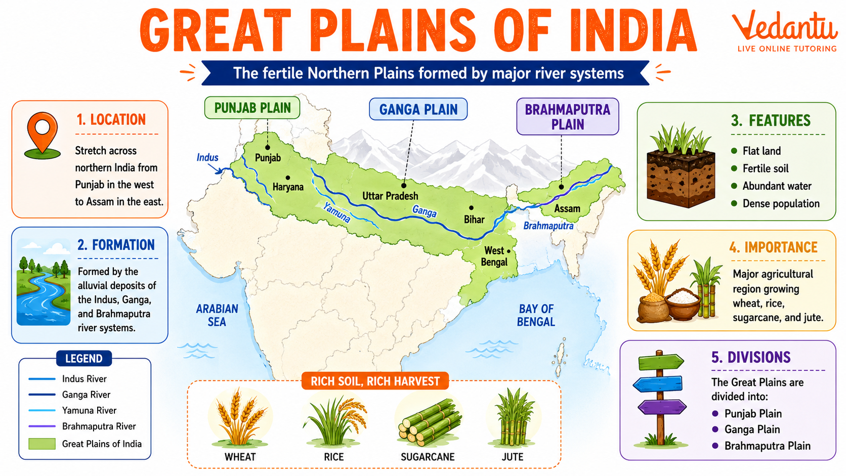
Location and Extent
The Great Plains lie south of the Himalayas and extend from Punjab in the west to Assam in the east. They stretch for about 2,400 km in length and vary between 150 to 300 km in width. These plains cover a large part of northern and eastern India.
- Western boundary - Punjab Plains
- Eastern boundary - Assam Plains
- Northern boundary - Himalayan foothills
- Southern boundary - Peninsular Plateau
Formation of the Great Plains
The Great Plains were formed by the deposition of sediments brought down by the Himalayan rivers and their tributaries. Over millions of years, these rivers deposited layers of silt, sand, and clay, creating fertile alluvial soil.
- Formed during the Tertiary period
- Created by Indus, Ganga, and Brahmaputra rivers
- Composed mainly of alluvial deposits
- Thickness of sediments ranges up to 1,000 to 2,000 meters
Divisions of the Great Plains
The Great Plains are generally divided into three major parts based on river systems.
Major Divisions of the Great Plains
| Division | River System | States Covered |
|---|---|---|
| Punjab Plains | Indus and its tributaries | Punjab, Haryana |
| Ganga Plains | Ganga and its tributaries | Uttar Pradesh, Bihar, West Bengal |
| Brahmaputra Plains | Brahmaputra River | Assam |
Each division has unique features but shares common characteristics such as fertile soil, flat terrain, and dense population.
Relief Features of the Plains
The Great Plains are not entirely uniform. Based on relief and soil composition, they are further divided into smaller regions.
- Bhabar - Narrow belt along the Himalayan foothills with porous soil
- Terai - Marshy and swampy region south of Bhabar
- Bhangar - Older alluvial soil found in elevated areas
- Khadar - Newer alluvial soil deposited annually by floods
Soil and Agriculture
The alluvial soil of the Great Plains is extremely fertile and suitable for a variety of crops. Availability of water through rivers and irrigation canals supports intensive farming.
Major Crops
- Wheat
- Rice
- Sugarcane
- Maize
- Jute
Due to fertile soil and favorable climate, this region is often called the food bowl of India.
Climate of the Great Plains
The climate of the Great Plains ranges from subtropical in the west to humid in the east. The region experiences hot summers, cold winters, and monsoon rainfall.
- Summer temperatures can exceed 40 degrees Celsius
- Winter temperatures may fall below 10 degrees Celsius
- Heavy rainfall in eastern regions
- Frequent floods in Bihar and Assam
Economic and Cultural Importance
The Great Plains are the most densely populated region of India. Several major cities such as Delhi, Kolkata, Lucknow, and Patna are located here. The plains have been the cradle of ancient civilizations including the Indus Valley Civilization.
- High agricultural productivity
- Well-developed transport network
- Historical and cultural centers
- Industrial and commercial activities
Key Facts About the Great Plains of India
- Also called the Indo-Gangetic-Brahmaputra Plains
- Formed by alluvial deposits
- One of the most fertile regions in the world
- Supports nearly 40 percent of India’s population
- Important for agriculture and food production
Conclusion
The Great Plains of India are a vital geographical region that significantly influences the country’s agriculture, economy, and population distribution. Formed by river deposits and enriched with fertile alluvial soil, these plains support millions of people and produce a major share of India’s food grains. Understanding the physical features, divisions, and importance of the Great Plains is essential for students preparing for school exams, competitive exams, and general awareness tests.
FAQs on Great Plains in India – Geography, Rivers and Importance
1. What are the Great Plains of India?
The Great Plains of India are vast, fertile lowlands formed by river deposits in northern India.
- Also known as the Indo-Gangetic Plains or Northern Plains
- Formed by the rivers Indus, Ganga, and Brahmaputra and their tributaries
- Stretch across states like Punjab, Haryana, Uttar Pradesh, Bihar, and West Bengal
- Known for fertile alluvial soil and dense population
These plains are important for agriculture, settlements, and Indian civilization.
2. How were the Great Plains of India formed?
The Great Plains were formed by the deposition of sediments brought by Himalayan rivers over millions of years.
- Rivers like Ganga, Yamuna, Indus, and Brahmaputra carried silt
- Deposits filled a large depression between the Himalayas and the Peninsular Plateau
- Created fertile alluvial plains
- Continuous process of erosion and deposition
This formation explains why the Northern Plains are extremely fertile and agriculturally rich.
3. What are the main divisions of the Northern Plains?
The Northern Plains of India are divided into three main sections based on river systems.
- Punjab Plains (Indus River system)
- Ganga Plains (Ganga and Yamuna rivers)
- Brahmaputra Plains (Assam region)
These divisions are commonly asked in GK and competitive exams under Indian geography topics.
4. Why are the Great Plains of India important for agriculture?
The Great Plains are highly important for agriculture due to their fertile soil and water availability.
- Rich alluvial soil suitable for crops
- Adequate irrigation from rivers and canals
- Flat land ideal for farming
- Major crops: wheat, rice, sugarcane, and pulses
These features make the Northern Plains the food-producing heartland of India.
5. What is the difference between Bhabar, Terai, Bhangar, and Khadar?
The Northern Plains are divided into Bhabar, Terai, Bhangar, and Khadar based on soil and location.
- Bhabar: Pebble-covered belt near Himalayan foothills
- Terai: Marshy, forested region south of Bhabar
- Bhangar: Older alluvial soil, less fertile
- Khadar: Newer alluvial soil, very fertile
These divisions are key concepts in Indian geography and school exams.
6. Which rivers flow through the Great Plains of India?
The Great Plains of India are drained by major Himalayan rivers and their tributaries.
- Indus River and its tributaries (Jhelum, Chenab, Ravi, Beas, Sutlej)
- Ganga River and tributaries (Yamuna, Ghaghara, Gandak, Kosi)
- Brahmaputra River in Assam
These river systems make the plains fertile and densely populated.
7. Why are the Great Plains densely populated?
The Northern Plains are densely populated due to fertile land and economic opportunities.
- Fertile soil supports intensive agriculture
- Availability of water and transport routes
- Development of major cities like Delhi, Kolkata, Lucknow, and Patna
- Favorable climate and flat terrain
These factors attract settlements, industries, and trade activities.
8. What type of soil is found in the Great Plains?
The dominant soil in the Great Plains of India is alluvial soil.
- Formed by river deposits
- Rich in nutrients like potash and lime
- Suitable for crops like rice, wheat, and sugarcane
- Divided into Bhangar (old) and Khadar (new)
This soil type makes the region one of the most productive agricultural zones in India.
9. What is the climate of the Great Plains of India?
The Great Plains experience a subtropical climate with seasonal variations.
- Hot summers (April–June)
- Monsoon rains (June–September)
- Cool winters (December–February)
- Occasional fog in northern areas
This climate supports multiple cropping seasons like Kharif and Rabi.
10. What is the economic importance of the Great Plains of India?
The Great Plains of India play a major role in the country’s economy.
- Backbone of Indian agriculture and food production
- Major industrial and trade centers
- Well-developed transport networks (roads, railways)
- Supports a large population workforce
Due to these factors, the Northern Plains are vital for India’s economic growth and development.