


Changes in Political Map of India Since 1947 in Hindi: State Reorganization and Major Boundary Changes
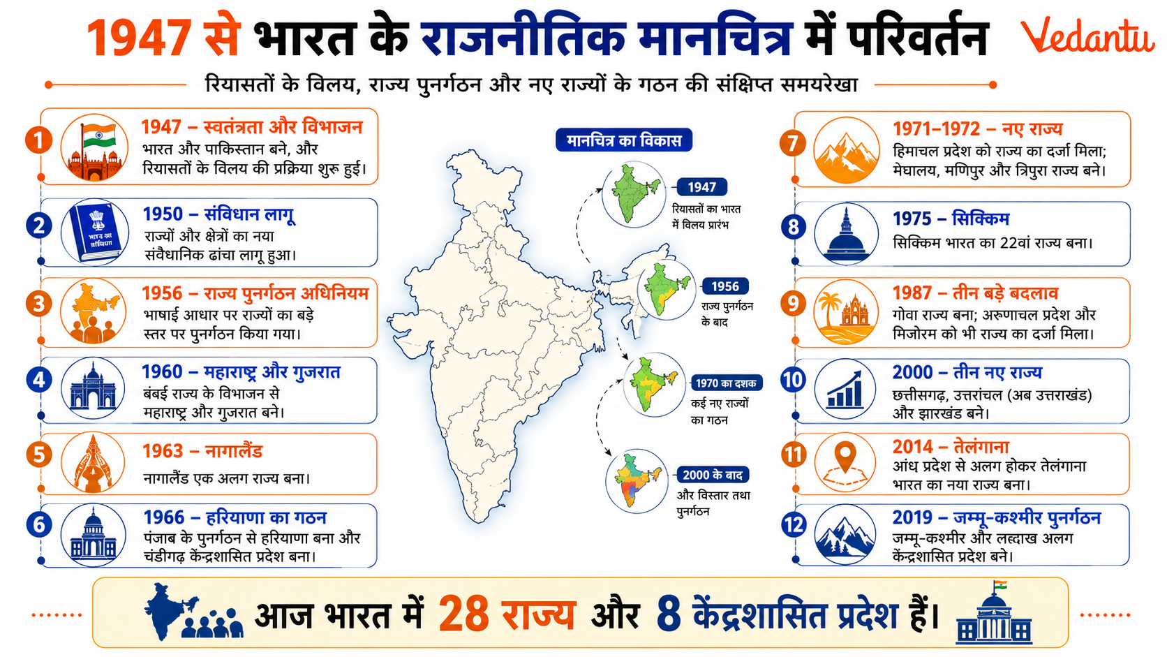
भारत की स्वतंत्रता 15 अगस्त 1947 को प्राप्त हुई, लेकिन इसके साथ ही देश के राजनीतिक मानचित्र में बड़े पैमाने पर परिवर्तन हुए। विभाजन, रियासतों का विलय, राज्यों का पुनर्गठन और नए राज्यों का निर्माण - इन सभी घटनाओं ने भारत के वर्तमान राजनीतिक स्वरूप को आकार दिया। 1947 के बाद से भारत का राजनीतिक नक्शा लगातार बदलता रहा है, जिसका उद्देश्य प्रशासनिक सुविधा, भाषाई पहचान और क्षेत्रीय संतुलन को बनाए रखना था। यह विषय सामान्य ज्ञान, प्रतियोगी परीक्षाओं और शैक्षणिक दृष्टि से अत्यंत महत्वपूर्ण है।
1947 में भारत का राजनीतिक स्वरूप
स्वतंत्रता के समय भारत दो भागों में विभाजित हुआ - भारत और पाकिस्तान। इसके अतिरिक्त, देश में लगभग 565 देशी रियासतें थीं, जिन्हें भारतीय संघ में शामिल करना एक बड़ी चुनौती थी। उस समय भारत को मुख्य रूप से चार श्रेणियों में विभाजित किया गया था - पार्ट A, पार्ट B, पार्ट C और पार्ट D राज्य।
- पार्ट A राज्य - पूर्व ब्रिटिश प्रांत
- पार्ट B राज्य - बड़ी देशी रियासतें
- पार्ट C राज्य - छोटी रियासतें और मुख्य आयुक्त क्षेत्र
- पार्ट D राज्य - अंडमान और निकोबार द्वीप समूह
देशी रियासतों का विलय
सरदार वल्लभभाई पटेल और वी पी मेनन के प्रयासों से अधिकांश रियासतों का भारत में विलय हुआ। हैदराबाद, जूनागढ़ और कश्मीर जैसे राज्यों के विलय में विशेष राजनीतिक और सैन्य प्रयास किए गए। यह प्रक्रिया भारत की एकता और अखंडता के लिए अत्यंत महत्वपूर्ण थी।
राज्यों का भाषाई आधार पर पुनर्गठन
स्वतंत्रता के बाद राज्यों की सीमाएं मुख्य रूप से प्रशासनिक आधार पर थीं। 1953 में आंध्र प्रदेश की मांग के बाद भाषाई आधार पर राज्यों के पुनर्गठन की प्रक्रिया शुरू हुई। 1956 में राज्य पुनर्गठन अधिनियम लागू किया गया, जिसके तहत राज्यों की सीमाएं भाषाई आधार पर तय की गईं।
राज्य पुनर्गठन अधिनियम 1956 की मुख्य बातें
- 14 राज्यों और 6 केंद्र शासित प्रदेशों का गठन
- पार्ट A, B, C, D की श्रेणियों का अंत
- भाषाई समानता को प्राथमिकता
1960 से 2000 तक प्रमुख परिवर्तन
1960 से 2000 के बीच नए राज्यों का गठन
| वर्ष | नया राज्य | किस राज्य से अलग हुआ |
|---|---|---|
| 1960 | महाराष्ट्र और गुजरात | बॉम्बे राज्य |
| 1966 | हरियाणा | पंजाब |
| 2000 | झारखंड, छत्तीसगढ़, उत्तराखंड | बिहार, मध्य प्रदेश, उत्तर प्रदेश |
इन परिवर्तनों का उद्देश्य प्रशासनिक सुविधा, क्षेत्रीय विकास और स्थानीय पहचान को सशक्त बनाना था।
2000 के बाद के परिवर्तन
2000 के बाद भी भारत के राजनीतिक मानचित्र में महत्वपूर्ण बदलाव हुए। 2014 में तेलंगाना राज्य का गठन आंध्र प्रदेश से अलग करके किया गया। 2019 में जम्मू और कश्मीर राज्य का पुनर्गठन कर इसे दो केंद्र शासित प्रदेशों - जम्मू और कश्मीर तथा लद्दाख में विभाजित किया गया।
वर्तमान में भारत का राजनीतिक स्वरूप
| कुल राज्य | केंद्र शासित प्रदेश | विशेष टिप्पणी |
|---|---|---|
| 28 | 8 | 2019 के पुनर्गठन के बाद |
| भाषाई आधार प्रमुख | कुछ में विधान सभा | दिल्ली और पुडुचेरी |
वर्तमान में भारत में 28 राज्य और 8 केंद्र शासित प्रदेश हैं। कुछ केंद्र शासित प्रदेशों में विधान सभा भी है, जैसे दिल्ली और पुडुचेरी।
राजनीतिक मानचित्र में परिवर्तन के कारण
- भाषाई और सांस्कृतिक पहचान
- प्रशासनिक सुविधा
- क्षेत्रीय विकास की आवश्यकता
- राजनीतिक आंदोलनों और जन मांग
प्रतियोगी परीक्षाओं के लिए महत्वपूर्ण तथ्य
- 1956 - राज्य पुनर्गठन अधिनियम
- 1960 - महाराष्ट्र और गुजरात का गठन
- 2000 - तीन नए राज्यों का निर्माण
- 2014 - तेलंगाना भारत का 29वां राज्य बना
- 2019 - जम्मू और कश्मीर का पुनर्गठन
निष्कर्ष
1947 के बाद भारत के राजनीतिक मानचित्र में हुए परिवर्तन देश की एकता, प्रशासनिक दक्षता और सांस्कृतिक विविधता को संतुलित करने के प्रयासों का परिणाम हैं। विभाजन से लेकर राज्यों के पुनर्गठन और नए राज्यों के गठन तक, यह प्रक्रिया निरंतर चलती रही है। यह विषय भारतीय राजनीति और संविधान की समझ के लिए अत्यंत महत्वपूर्ण है तथा प्रतियोगी परीक्षाओं में अक्सर पूछा जाता है।
FAQs on Changes in Political Map of India Since 1947 in Hindi – Explained for Students
1. 1947 के बाद भारत के राजनीतिक मानचित्र में क्या प्रमुख परिवर्तन हुए?
1947 के बाद भारत के राजनीतिक मानचित्र में सबसे बड़े बदलाव विभाजन, रियासतों का विलय और राज्यों के पुनर्गठन के रूप में हुए।
मुख्य परिवर्तन:
• भारत-पाकिस्तान विभाजन (1947) – पंजाब और बंगाल का बंटवारा
• 562 रियासतों का विलय – सरदार वल्लभभाई पटेल के नेतृत्व में
• राज्यों का पुनर्गठन अधिनियम, 1956 – भाषाई आधार पर राज्यों का गठन
• नए राज्यों का निर्माण – छत्तीसगढ़, झारखंड, उत्तराखंड (2000), तेलंगाना (2014)
यह प्रक्रिया Indian Political Map Changes after Independence के रूप में जानी जाती है।
2. भारत का विभाजन 1947 में क्यों और कैसे हुआ?
भारत का विभाजन धार्मिक आधार पर हिंदू और मुस्लिम समुदायों के बीच राजनीतिक मतभेदों के कारण हुआ।
मुख्य कारण:
• मुस्लिम लीग की अलग राष्ट्र की मांग
• द्विराष्ट्र सिद्धांत (Two Nation Theory)
• माउंटबेटन योजना (3 जून 1947)
• 15 अगस्त 1947 को भारत और पाकिस्तान का निर्माण
इस घटना ने Political Map of India 1947 को स्थायी रूप से बदल दिया।
3. रियासतों का भारत में विलय कैसे हुआ?
स्वतंत्रता के समय भारत में 562 देशी रियासतें थीं, जिन्हें भारतीय संघ में मिलाया गया।
मुख्य बिंदु:
• नेतृत्व: सरदार वल्लभभाई पटेल और वी.पी. मेनन
• साधन: Instrument of Accession
• प्रमुख मामले: हैदराबाद (ऑपरेशन पोलो), जूनागढ़, कश्मीर
इसे Integration of Princely States कहा जाता है, जो राजनीतिक एकीकरण का महत्वपूर्ण चरण था।
4. राज्यों का पुनर्गठन अधिनियम 1956 क्या था?
1956 का States Reorganisation Act भाषाई आधार पर राज्यों के पुनर्गठन का कानून था।
मुख्य तथ्य:
• फजल अली आयोग (1953) की सिफारिशें
• 1 नवंबर 1956 से लागू
• आंध्र प्रदेश पहला भाषाई राज्य (1953)
• 14 राज्य और 6 केंद्र शासित प्रदेश बने
इस अधिनियम ने India Political Map Reorganization में बड़ा बदलाव किया।
5. भाषाई आधार पर राज्यों का गठन क्यों किया गया?
भाषाई आधार पर राज्यों का गठन प्रशासनिक सुविधा और सांस्कृतिक पहचान को सुरक्षित रखने के लिए किया गया।
मुख्य कारण:
• क्षेत्रीय भाषाओं का संरक्षण
• प्रशासन में सरलता
• जनता की मांग और आंदोलन (जैसे पोट्टि श्रीरामुलु आंदोलन)
यह प्रक्रिया Linguistic Reorganisation of States के नाम से जानी जाती है।
6. 2000 के बाद भारत में कौन-कौन से नए राज्य बने?
सन् 2000 के बाद क्षेत्रीय मांगों के आधार पर नए राज्यों का गठन किया गया।
मुख्य राज्य:
• छत्तीसगढ़ – मध्य प्रदेश से (1 नवम्बर 2000)
• झारखंड – बिहार से (15 नवम्बर 2000)
• उत्तराखंड – उत्तर प्रदेश से (9 नवम्बर 2000)
• तेलंगाना – आंध्र प्रदेश से (2 जून 2014)
ये परिवर्तन Recent Changes in Political Map of India का हिस्सा हैं।
7. जम्मू-कश्मीर के पुनर्गठन से भारत के मानचित्र में क्या बदलाव आया?
5 अगस्त 2019 को अनुच्छेद 370 हटाकर जम्मू-कश्मीर का पुनर्गठन किया गया।
मुख्य परिवर्तन:
• राज्य को दो केंद्र शासित प्रदेश में विभाजित किया गया:
– जम्मू और कश्मीर
– लद्दाख
• Jammu and Kashmir Reorganisation Act, 2019 लागू
इससे Latest Political Map of India में महत्वपूर्ण संशोधन हुआ।
8. भारत में वर्तमान में कितने राज्य और केंद्र शासित प्रदेश हैं?
वर्तमान में भारत में 28 राज्य और 8 केंद्र शासित प्रदेश हैं।
केंद्र शासित प्रदेश:
• दिल्ली
• पुडुचेरी
• अंडमान-निकोबार
• चंडीगढ़
• दमन और दीव तथा दादरा और नगर हवेली (विलय के बाद एक UT)
• लक्षद्वीप
• जम्मू और कश्मीर
• लद्दाख
यह जानकारी Current Political Map of India 2026 के अनुसार है।
9. दादरा और नगर हवेली तथा दमन और दीव का विलय कब हुआ?
26 जनवरी 2020 को दादरा और नगर हवेली तथा दमन और दीव का विलय किया गया।
मुख्य तथ्य:
• एक ही केंद्र शासित प्रदेश बनाया गया
• प्रशासनिक खर्च कम करने का उद्देश्य
• संसद द्वारा पारित कानून के तहत विलय
यह Union Territory Merger 2020 के रूप में जाना जाता है।
10. भारत के राजनीतिक मानचित्र में बदलाव का महत्व क्या है?
भारत के राजनीतिक मानचित्र में बदलाव राष्ट्रीय एकता, प्रशासनिक सुधार और लोकतांत्रिक विकास को दर्शाते हैं।
महत्व:
• राष्ट्रीय एकीकरण को मजबूत किया
• क्षेत्रीय पहचान को मान्यता दी
• प्रशासनिक दक्षता बढ़ाई
• संघीय ढांचे को सुदृढ़ किया
ये परिवर्तन Evolution of Political Map of India since 1947 को समझने के लिए महत्वपूर्ण हैं, विशेषकर GK, UPSC, SSC और अन्य प्रतियोगी परीक्षाओं के लिए।