


Important Questions for Class 9 Social Science Chapter 2 – Shaping of the Earth's Surface
Practise these solved questions on Earth's structure, tectonic plates, different agents of erosion, landform formation and disaster-related applications.
Class 9 Social Science Chapter 2 Important Questions MCQ with Answers
Q1. Tectonic plates move slowly over which layer of the Earth?
(a) Inner core
(b) Outer core
(c) Asthenosphere
(d) Continental crust
Answer: (c) Asthenosphere
Explanation:
The asthenosphere is a hot, mobile layer beneath the lithosphere.
Its ability to flow slowly allows the rigid tectonic plates above it to move.
Convection currents in the mantle help drive this movement.
Q2. Two tectonic plates move away from each other, allowing magma to rise and form new crust. Which type of plate boundary is involved?
(a) Convergent boundary
(b) Divergent boundary
(c) Transform boundary
(d) Collision boundary
Answer: (b) Divergent boundary
Explanation:
At a divergent boundary, tectonic plates move apart.
Magma rises from below and cools to form new crust.
The Mid-Atlantic Ridge is an example of a landform created by this process.
Q3. Which of the following is an example of biological weathering?
(a) Rocks breaking because of temperature changes
(b) Minerals reacting with acidic rainwater
(c) Plant roots growing into cracks and splitting rocks
(d) River water carrying sediments downstream
Answer: (c) Plant roots growing into cracks and splitting rocks.
Explanation:
Biological weathering occurs when living organisms cause rocks to break down.
Plant roots can enter cracks and gradually widen them as they grow.
Unlike erosion, weathering does not involve transporting the broken material away.
Q4. A glacier moves through a mountain valley, widening its sides and deepening its floor. Which landform is most likely to develop?
(a) V-shaped valley
(b) U-shaped valley
(c) River delta
(d) dune
Answer: (b) U-shaped valley
Explanation:
Moving glaciers erode the sides and floors of valleys.
Over time, this action creates broad valleys with steep sides and relatively flat floors.
These are called U-shaped valleys.
Q5. Assertion–Reason Question
Assertion (A): Glacial Lake Outburst Floods (GLOFs) can cause severe damage in valleys downstream of glacial lakes.
Reason (R): A natural dam holding a glacial lake may fail suddenly, releasing large volumes of water.
Choose the correct option.
(a) Both A and R are true, and R correctly explains A.
(b) Both A and R are true, but R does not explain A.
(c) A is true, but R is false.
(d) A is false, but R is true.
Answer: (a) Both A and R are true, and R correctly explains A.
Explanation:
Glacial lakes may be held back by ice or loose rock material called moraines.
Heavy rainfall, glacier melting, landslides or avalanches can weaken these natural dams.
When a dam fails, water may rush downstream and damage settlements, roads and bridges.
Class 9 Social Science Chapter 2 Very Short Answer Questions
Q6. What are tectonic plates? Name their three main types.
Answer:
Tectonic plates are massive, slowly moving pieces of the Earth's lithosphere.
The three main types described in the chapter are:
Continental plates: Carry continents.
Oceanic plates: Carry ocean floors.
Mixed plates: Carry both continents and ocean floors.
Their movement helps create mountains, volcanoes, earthquakes and ocean basins.
Q7. What is the main difference between weathering and erosion?
Answer:
Weathering is the breaking down of rocks into smaller pieces without moving the material away.
Erosion involves wearing away and transporting rock and soil particles through agents such as water, wind, glaciers and waves.
Example: Plant roots splitting a rock is weathering, while a river carrying broken rock particles downstream is erosion.
Q8. What are agents of erosion? Name any four.
Answer:
Agents of erosion are natural forces that wear down, transport and deposit materials, gradually reshaping the Earth's surface.
Four important agents are:
Running water
Glaciers
Wind
Sea waves
Groundwater is another important agent of erosion.
Q9. Differentiate between stalactites and stalagmites.
Answer:
Stalactites: Mineral deposits that hang from the ceilings of caves.
Stalagmites: Mineral deposits that grow upwards from cave floors.
Both form through the deposition of dissolved minerals from dripping water.
When they join, they may form a pillar or column.
Class 9 Social Science Chapter 2 Short Answer Questions
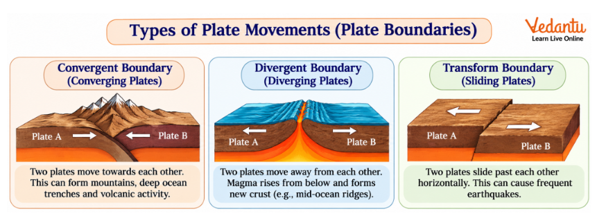
Q10. Explain the three types of tectonic plate boundaries with examples.
Answer:
Tectonic plate boundaries are areas where two plates meet.
They are classified according to the direction of plate movement.
Explanation:
At convergent boundaries, plates collide, which may cause the crust to fold or one plate to sink beneath another.
At divergent boundaries, magma rises between separating plates and forms new crust.
At transform boundaries, friction builds as plates slide past each other, sometimes causing earthquakes.
Q11. Why do earthquakes and volcanoes frequently occur around the Pacific Ring of Fire?
Answer:
The Pacific Ring of Fire is a region around the Pacific Ocean where many tectonic plate boundaries are located.
Reasons for frequent activity:
Several tectonic plates meet around the Pacific Ocean.
At many convergent boundaries, one plate sinks beneath another.
This movement can produce magma that rises towards the surface.
Stress along plate boundaries can also cause earthquakes.
As a result, the region experiences frequent earthquakes and volcanic eruptions.
Conclusion: The distribution of earthquakes and volcanoes is closely connected to tectonic plate boundaries.
Q12. How do contouring, bunding and terracing help prevent soil erosion?
Answer:
Contouring, bunding and terracing are methods used to conserve soil and water, particularly on sloping land.
1. Contouring
Trenches or agricultural practices follow the contour lines of a hillside.
This slows surface runoff and allows more water to enter the soil.
2. Bunding
Earthen embankments are built along contour lines.
They reduce the speed of flowing water and prevent fertile soil from being washed away.
3. Terracing
Stepped surfaces are created on hillsides.
These steps reduce the speed of water flowing downhill and provide more stable areas for cultivation.
Conclusion: These methods help protect farmland, conserve moisture and reduce soil loss.
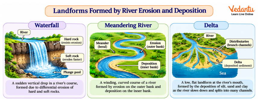
Q13. Explain how rivers form waterfalls, meanders and deltas.
Answer:
Rivers create different landforms through erosion, transportation and deposition.
1. Waterfalls
Waterfalls generally form in the upper course of rivers where water flows over a steep drop.
Differences in rock resistance can cause softer rocks to erode faster than harder rocks, creating a sudden drop.
2. Meanders
Meanders are winding river bends commonly found in the middle and lower courses.
The river erodes the outer bank and deposits sediments along the inner bank, gradually developing curved loops.
3. Deltas
Deltas form near river mouths when flowing water slows down and deposits sediments.
Over time, these deposits may create broad, fertile areas divided by distributaries.
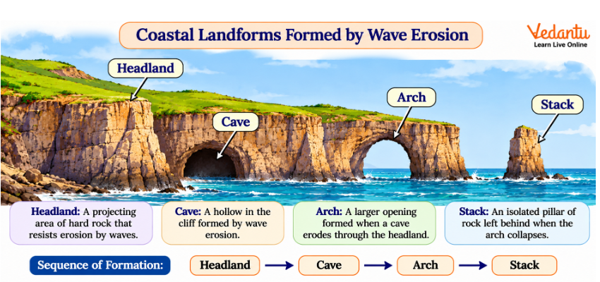
Q14. How do sea waves form cliffs, caves, arches and stacks?
Answer:
Sea waves continuously erode coastal rocks, gradually changing the shape of coastlines.
Formation process:
Sea cliff: Waves erode the base of a rocky coast, contributing to the development and retreat of steep rock faces.
Sea cave: Waves enlarge cracks or weaker sections of rock, creating hollow spaces.
Sea arch: Continued erosion may extend a cave through a headland, forming an arch.
Sea stack: When an arch collapses, an isolated pillar of rock may remain.
These landforms develop over long periods through repeated wave action.
Importance:
They attract tourists and support local tourism.
They help us understand coastal erosion.
Their formation can create risks for nearby settlements and infrastructure.
Q15. What are moraines? Explain the three main types of moraines formed by glaciers.
Answer:
Moraines are accumulations of rocks, soil and other debris transported and deposited by glaciers.
The deposited material is called glacial till.
Types of moraines:
1. Lateral moraine
Forms along the sides of a glacier as debris accumulates near its edges.
2. Terminal moraine
Forms near the furthest point reached by a glacier and marks its maximum advance.
3. Medial moraine
Forms when two glaciers join and the lateral moraines along their meeting edges combine.
Importance:
Moraines can influence the formation of natural lakes, modify drainage patterns and provide evidence of past glacier movement.
Q16. How does wind create different landforms in desert regions?
Answer:
Wind shapes desert landscapes by eroding, transporting and depositing loose sand and soil particles.
Major wind-created landforms:
Yardangs: Streamlined ridges formed by wind erosion of rocks.
Ventifacts: Rocks polished or shaped by wind-driven sand.
Deflation hollows: Depressions formed when wind removes loose material.
Dunes: Hills or ridges formed when wind deposits sand.
Types of dunes:
Conclusion: Wind erosion and deposition continuously change desert landscapes and influence settlements, transport and agriculture.
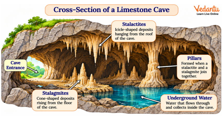
Q17. How does underground water form caves and other Karst landforms?
Answer:
Karst topography develops mainly in regions containing soluble rocks such as limestone.
Rainwater containing dissolved carbon dioxide becomes weakly acidic.
As this water passes through cracks in limestone, it slowly dissolves the rock.
Major Karst landforms include:
Caves: Underground hollow spaces formed by rock dissolution.
Sinkholes: Depressions formed when the ground sinks or collapses into an underground cavity.
Stalactites: Mineral deposits hanging from cave ceilings.
Stalagmites: Mineral deposits rising from cave floors.
Underground rivers: Water channels flowing through cave systems.
Conclusion: Underground water changes the landscape through chemical weathering, erosion and mineral deposition.
Class 9 Social Science Chapter 2 Long Answer and Application-Based Questions
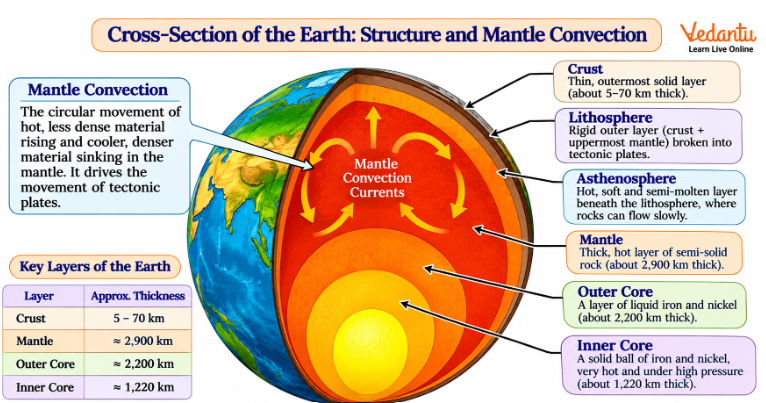
Q18. Explain the structure of the Earth and how convection currents contribute to tectonic plate movement.
Answer:
The Earth consists of three major internal layers: the crust, mantle and core.
1. Crust
The crust is the Earth's outermost layer.
It forms the surface on which continents and ocean floors exist.
Continental crust is generally thicker than oceanic crust.
2. Mantle
The mantle lies beneath the crust.
It is a very thick, hot layer of mostly solid rock that can flow slowly over long periods.
3. Core
The core is the innermost part of the Earth.
It consists mainly of iron and nickel and is divided into:
Outer core – a liquid layer.
Inner core – a solid, extremely hot and dense region.
Lithosphere and asthenosphere
The lithosphere consists of the crust and rigid uppermost mantle.
It is divided into tectonic plates.
Beneath it lies the weaker, slowly flowing asthenosphere.
How do convection currents move plates?
Heat from inside the Earth causes hotter mantle material to rise.
Cooler material tends to sink.
This circulation produces convection currents.
Mantle movement contributes to the movement of tectonic plates.
As tectonic plates interact, mountains, earthquakes, volcanoes and ocean basins can form.
Conclusion:
The Earth's internal heat and mantle movement play an important role in the continuous reshaping of its surface.
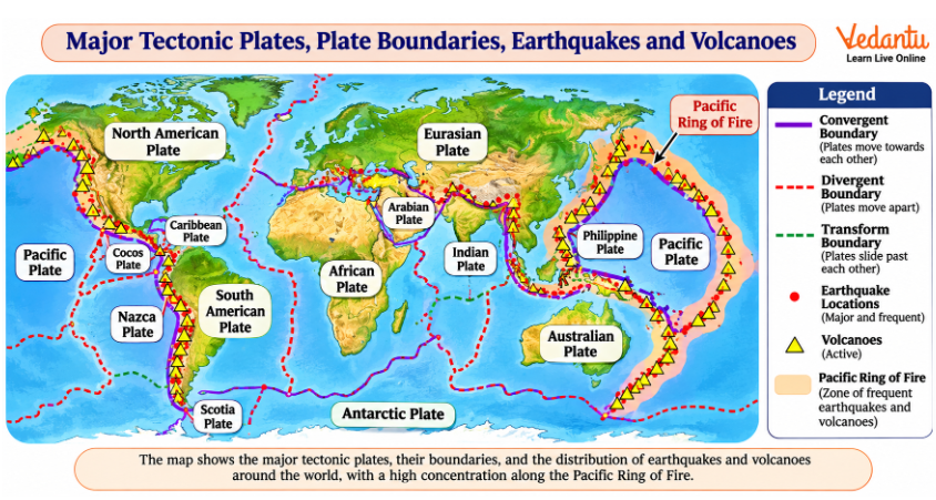
Q19. Image-Based Question: Understanding Plate Movements and Earthquake Distribution
A world map shows the major tectonic plates and the locations of active volcanoes and earthquake origins.
Most earthquake and volcano symbols are concentrated near the boundaries of tectonic plates, particularly around the Pacific Ocean.
Answer the following questions:
(a) Why are earthquakes concentrated near plate boundaries?
(b) Identify the region surrounding the Pacific Ocean with frequent volcanic activity.
(c) Which plate boundary creates new oceanic crust?
(d) Why is knowledge of plate boundaries useful for disaster preparedness?
Solution:
(a) Earthquake concentration
Earthquakes commonly occur near plate boundaries because tectonic plates collide, move apart or slide past each other.
Stress builds along faults and may be released suddenly as seismic energy.
(b) Pacific Ring of Fire
The Ring of Fire is a broad zone surrounding much of the Pacific Ocean.
It contains many active volcanoes and earthquake-prone regions.
(c) Divergent boundary
At divergent boundaries, plates move apart.
Magma rises, cools and forms new oceanic crust.
(d) Disaster preparedness
Understanding plate boundaries helps identify areas that may face greater earthquake and volcanic hazards.
This information supports safer construction, land-use planning and disaster preparedness.
Conclusion:
The distribution of earthquakes and volcanoes provides important evidence of tectonic plate activity.
Q20. Explain how different landforms influence human settlements, occupations and economic activities.
Answer:
Landforms influence where people live, the occupations they follow and the resources available to them.
1. Mountains
Mountains can act as natural barriers and affect climate and transport.
They support activities such as tourism, forestry and, in suitable areas, terrace farming.
Mountain rivers can also provide water and opportunities for hydroelectric power.
2. Plains
Plains generally provide relatively level land and, in many regions, fertile soil.
They support agriculture, transport networks and large human settlements.
3. River Valleys and Deltas
Rivers provide fresh water and transport routes.
Deltas often contain fertile alluvial soil suitable for crops such as rice and jute.
They may also support fishing and trade.
4. Coastal Areas
Coasts provide opportunities for fishing, ports, shipping and tourism.
Harbours connect different regions through maritime trade.
5. Deserts
Scarce water and harsh climatic conditions can limit settlements.
However, deserts also support certain trade routes, tourism and occupations adapted to dry conditions.
Comparison:
Conclusion:
Landforms influence human life by shaping access to resources, transport, settlements and economic opportunities.
Q21. Compare the work of rivers, glaciers, wind, sea waves and underground water in shaping the Earth's surface.
Answer:
Different natural agents modify the Earth's surface through erosion, transportation and deposition.
1. Running Water
Rivers erode rocks and soil, carry sediments and deposit them along their courses.
They create landforms such as valleys, waterfalls, meanders and deltas.
2. Glaciers
Glaciers are large moving masses of ice.
They erode valleys and transport debris.
They create U-shaped valleys, cirques, hanging valleys and moraines.
3. Wind
Wind removes and carries loose particles, especially in dry regions.
It forms yardangs, deflation hollows and dunes.
4. Sea Waves
Sea waves reshape coastlines through erosion and deposition.
They form beaches, cliffs, caves, arches and stacks.
5. Underground Water
Groundwater dissolves soluble rocks such as limestone.
It forms caves, sinkholes and underground drainage systems.
Mineral deposition can produce stalactites and stalagmites.
Comparison Table:
Conclusion:
These agents continuously reshape the Earth's surface by removing, transporting and depositing materials.
Q22. Compare landslides, avalanches, Glacial Lake Outburst Floods and dust storms. Explain their major causes and preventive measures.
Answer:
Different landforms are associated with different natural hazards.
Their causes depend on local conditions, climate and human activities.
1. Landslides
Landslides involve the movement of rock, soil or debris down a slope.
Causes:
Heavy or continuous rainfall
Earthquakes
Steep and unstable slopes
Deforestation and unplanned construction
Mitigation measures:
Improve slope drainage.
Protect vegetation.
Use suitable slope-stabilisation measures.
Avoid unsafe construction in landslide-prone areas.
2. Avalanches
Avalanches occur when snow suddenly moves down a steep mountain slope.
Causes:
Heavy snowfall
Weak layers within the snowpack
Temperature changes
Vibrations or other disturbances
Mitigation measures:
Monitor snow conditions.
Follow avalanche warnings.
Restrict activities in high-risk zones.
Use appropriate protective structures where suitable.
3. Glacial Lake Outburst Floods (GLOFs)
GLOFs occur when large amounts of water suddenly escape from a glacial lake.
Causes:
Weakening or failure of natural dams
Heavy rainfall
Glacier melting
Landslides or avalanches affecting the lake
Mitigation measures:
Monitor glacial lakes.
Establish early-warning systems.
Identify vulnerable downstream settlements.
Prepare evacuation plans.
4. Dust Storms
Dust storms occur when strong winds lift loose, dry soil and sand into the air.
Causes:
Strong winds
Prolonged drought
Sparse vegetation
Exposed and dry soil
Mitigation measures:
Protect vegetation.
Reduce soil exposure.
Use suitable soil conservation practices.
Follow weather warnings during severe dust storms.
Comparison:
Conclusion:
Understanding the causes of these disasters helps communities plan safer settlements and adopt suitable preventive measures.
Q23. Case-Based Question: Landslide Risk in a Mountain Village
A mountain village experiences heavy rainfall every monsoon. Over the past few years, several trees have been removed to build roads and houses. Small cracks have appeared on the slopes, and loose soil sometimes slides onto the road.
Answer the following questions:
(a) Identify the natural disaster that may affect the village.
(b) Explain how rainfall increases the risk.
(c) How can deforestation make the slopes less stable?
(d) Suggest three measures to reduce the risk.
(e) Why should human activities be considered while planning development in mountainous regions?
Solution:
(a) Landslide
The village is at risk of landslides because the slopes are becoming unstable.
(b) Effect of rainfall
Heavy rainfall allows water to enter the soil and rock layers.
This increases their weight and can reduce their resistance to sliding.
As a result, material may move downhill.
(c) Effect of deforestation
Tree roots help bind soil and reduce erosion.
Removing vegetation exposes the soil to rainwater and runoff.
This can increase slope instability.
(d) Three preventive measures
Improve drainage: Prevent excess water from collecting within unstable slopes.
Protect vegetation: Maintain or restore suitable plant cover.
Stabilise vulnerable slopes: Use professionally designed retaining structures and avoid unsafe excavation.
(e) Importance of planned development
Road construction, mining and building activities can disturb slopes.
Development in mountainous areas should consider drainage, soil conditions, slope stability and local hazards.
Conclusion:
The case shows how natural conditions and human activities can combine to increase disaster risk. Careful planning and soil conservation can reduce the danger to people and infrastructure.
Important Topics to Revise for Class 9 Social Science Chapter 2
Use this quick-reference table to revise the major geographical processes and landforms before attempting the important questions.
How to Prepare Class 9 Social Science Chapter 2 Important Questions
Practise labelled diagrams of plate boundaries and major landforms.
Understand the difference between weathering, erosion and deposition.
Revise how rivers, glaciers, wind and waves shape landscapes.
Prepare short explanations of disaster causes and mitigation measures.
Exam Tip: For diagram-based questions, identify the natural process first and then explain how it creates the landform.
Download Class 9 Social Science Chapter 2 Important Questions PDF
Download the Class 9 Social Science Chapter 2 Important Questions PDF, once available, to practise solved MCQs, short answers and application-based questions offline. The PDF is regularly reviewed and updated to align with the latest syllabus.
CBSE Class 9 Social Science Chapter 2 Study Materials
Explore these study materials to strengthen your understanding of Shaping of the Earth's Surface.
CBSE Class 9 Social Science Chapter-wise Important Questions
Practise important questions from the other chapters of Class 9 Social Science Book 1 to strengthen your understanding of Geography, History, Political Science and Economics.
Important Study Materials for CBSE Class 9 Social Science
FAQs on Important Questions and Answers for Class 9 Social Science (Understanding Society India and Beyond PART-I) Chapter 2 – Shaping of the Earth's Surface | 2026–27
1. What are the main topics covered in Class 9 Social Science Chapter 2 important questions?
The important topics include Earth's interior, plate tectonics, earthquakes, volcanoes, weathering, erosion, river landforms, coastal features, glaciers, wind-created landforms and natural disasters. Students should also understand how these processes influence human settlements and activities.
2. What are the three types of tectonic plate boundaries?
The three types are convergent, divergent and transform boundaries. At convergent boundaries, plates move towards each other. At divergent boundaries, they move apart. At transform boundaries, plates slide past each other. These movements help explain mountains, earthquakes, volcanoes and oceanic ridges.
3. Why are earthquakes common along tectonic plate boundaries?
Tectonic plates continuously move and interact at their boundaries. Friction and resistance can cause stress to build within rocks. When this stress is released suddenly, seismic waves are produced, resulting in an earthquake.
4. What is the difference between weathering, erosion and deposition?
Weathering breaks rocks into smaller pieces without moving them. Erosion wears away and transports materials through agents such as water, wind and glaciers. Deposition occurs when transported materials settle in another location. Together, these processes reshape the Earth's surface.
5. Which diagrams are important for Class 9 Social Science Chapter 2?
Important diagrams include the Earth's interior, three types of plate boundaries, waterfalls, meanders, deltas, coastal arches and stacks, glacial valleys, moraines and limestone caves. Students should practise identifying and labelling the important features.
6. How are V-shaped and U-shaped valleys different?
V-shaped valleys are generally formed by river erosion, especially in steep upper river courses. U-shaped valleys are carved by glaciers, which widen and deepen existing valleys. V-shaped valleys have narrow floors, while U-shaped valleys have broader floors and steep sides.
7. How do rivers form meanders and deltas?
Meanders form when rivers erode their outer banks and deposit sediments along inner banks, gradually developing bends. Deltas form when rivers slow down near their mouths and deposit large amounts of sediment. These deposits may create fertile land divided by distributaries.
8. What are the main landforms created by sea waves?
Sea waves create beaches through sediment deposition and coastal cliffs, caves, arches and stacks through erosion. Repeated wave action changes coastal landscapes over time and influences tourism, fishing and human settlements.
9. What are the different types of dunes explained in Chapter 2?
The chapter discusses barchan, longitudinal, star and parabolic dunes. Barchan dunes are crescent-shaped; longitudinal dunes form long ridges, star dunes have several arms, and parabolic dunes are generally U-shaped and often stabilised by vegetation.
10. What is Karst topography in Class 9 Geography?
Karst topography develops mainly in areas containing soluble rocks such as limestone. Groundwater gradually dissolves the rocks, creating caves, sinkholes and underground channels. Mineral deposition inside caves can form stalactites and stalagmites.
11. Why are landslides common in steep mountainous regions?
Steep slopes, heavy rainfall, loose rocks and earthquakes can increase landslide risk. Human activities such as deforestation, road cutting and unplanned construction may further weaken slopes. Proper drainage, vegetation protection and planned construction can help reduce the risk.
12. What is a Glacial Lake Outburst Flood (GLOF)?
A GLOF occurs when a large quantity of water suddenly escapes from a glacial lake. This may happen when a natural dam made of ice or loose rock material fails. The released water can cause destructive floods in downstream valleys.
13. How do landforms influence human life and occupations?
Landforms influence settlements, agriculture, transport, tourism and trade. Fertile plains support farming, mountains provide opportunities for tourism and hydropower, and coastal areas support fishing and ports. Their physical conditions also affect the risks faced by nearby communities.
14. Are map-based questions important in Class 9 Social Science Chapter 2 MCQ practice?
Yes. Map-based questions can test the locations of major tectonic plates, plate boundaries and earthquake- or volcano-prone regions. Students should practise connecting the plate tectonics map with the distribution of earthquakes and volcanoes, particularly around the Pacific Ring of Fire.
15. How can I prepare Class 9 Social Science Chapter 2 important questions and answers for exams?
Start with plate tectonics and the three plate boundaries. Then revise weathering, erosion and landforms created by different natural agents. Practise diagrams and finish with disaster-related questions that require explanations of causes, effects and mitigation measures.
16. Where can I download the Class 9 Social Science Chapter 2 important questions PDF?
The Class 9 Social Science Chapter 2 important questions PDF download section will provide solved questions for offline practice once the PDF is published. Students can use the questions and answers on this page to revise in the meantime.
17. Which textbook contains Class 9 Social Science Chapter 2 Shaping of the Earth's Surface?
Chapter 2, Shaping of the Earth's Surface, is included in Understanding Society: India and Beyond – Part I. It introduces plate tectonics, external land-shaping processes, major landforms and natural disasters associated with different landscapes.