


Purvanchal Hill Range Location, States and Major Peaks
The Purvanchal Hills are the eastern extension of the Himalayan mountain system located in Northeast India. These hills form a curved chain of mountains beyond the Brahmaputra Valley and extend towards Myanmar. The Purvanchal Hills are significant in terms of geography, climate, biodiversity, and strategic importance. They are an essential topic in General Knowledge for school exams, competitive exams, and geography-related studies. Understanding the Purvanchal Hills helps students grasp the physical features of India and their impact on climate, vegetation, and human settlement.
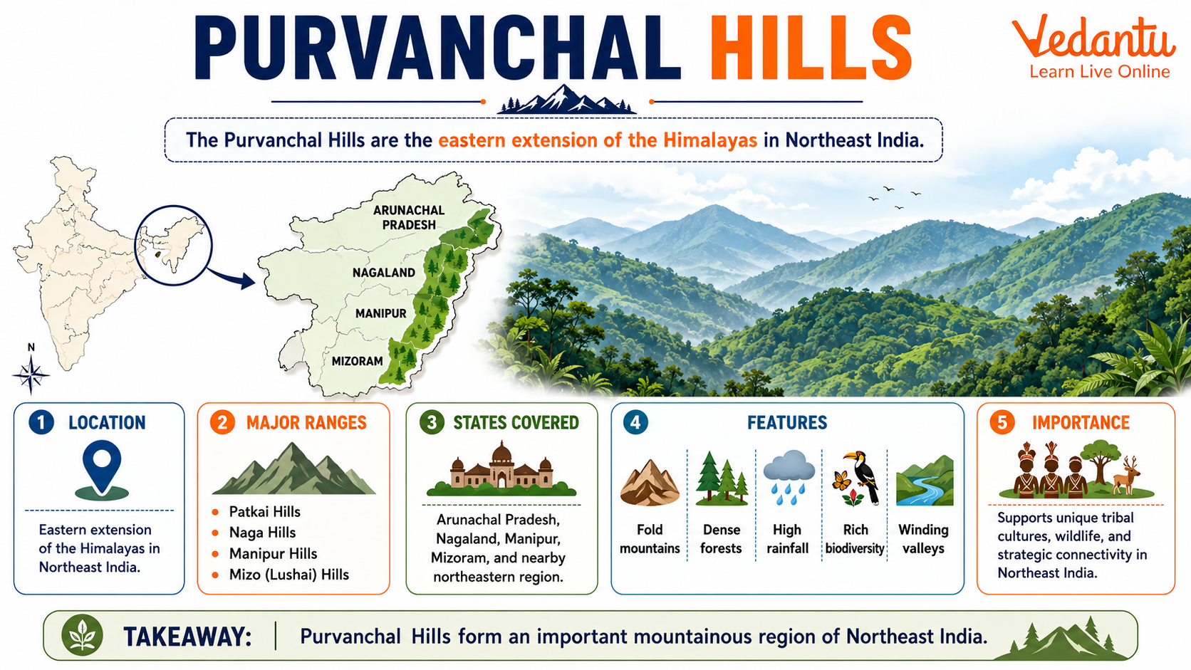
Location and Extent of Purvanchal Hills
The Purvanchal Hills lie in the northeastern part of India. They form the easternmost extension of the Himalayas after the Himalayas bend sharply towards the south near the Dihang Gorge. These hills run along the India-Myanmar border and cover parts of Arunachal Pradesh, Nagaland, Manipur, Mizoram, and Tripura.
- Located in Northeast India
- Extension of the Eastern Himalayas
- Stretch along the India-Myanmar border
- Cover states like Nagaland, Manipur, Mizoram, and Tripura
Major Hills of Purvanchal
The Purvanchal Hills consist of several parallel hill ranges. These ranges are not as high as the Greater Himalayas but are important for their geographical and ecological features.
Patkai Hills
The Patkai Hills lie in Arunachal Pradesh along the India-Myanmar border. They form the northernmost part of the Purvanchal Hills and are covered with dense forests.
Naga Hills
The Naga Hills are located in Nagaland and form an important part of the Purvanchal range. Mount Saramati, the highest peak in Nagaland, is situated here.
Manipur Hills
The Manipur Hills surround the central valley of Manipur. These hills separate Manipur from Myanmar and are known for their rich biodiversity.
Mizo or Lushai Hills
The Mizo Hills, also known as Lushai Hills, are located in Mizoram. These hills have steep slopes and deep valleys and are prone to heavy rainfall.
Major Ranges of Purvanchal Hills
| Hill Range | Location | Key Feature |
|---|---|---|
| Patkai Hills | Arunachal Pradesh | Dense forests and border with Myanmar |
| Naga Hills | Nagaland | Mount Saramati peak |
| Mizo Hills | Mizoram | Heavy rainfall and steep slopes |
These hill ranges collectively form the Purvanchal system and play a crucial role in influencing the climate and drainage patterns of Northeast India.
Physical Features
The Purvanchal Hills are characterized by medium height mountains, deep valleys, and dense forests. Unlike the snow-covered Himalayas, these hills are mostly covered with tropical evergreen forests due to heavy rainfall.
- Moderate height compared to the Greater Himalayas
- Covered with thick forests
- Receive heavy monsoon rainfall
- Complex network of rivers and streams
Climate and Vegetation
The region experiences a humid subtropical climate with heavy rainfall during the monsoon season. The abundant rainfall supports dense forests and rich biodiversity.
Climate
- Heavy rainfall during monsoon
- Moderate temperatures throughout the year
- High humidity levels
Vegetation
- Tropical evergreen forests
- Bamboo forests
- Rich wildlife including rare species
Economic and Strategic Importance
The Purvanchal Hills are important for agriculture, forestry, and border security. Shifting cultivation, also known as jhum cultivation, is widely practiced in this region. The hills also have strategic importance because they lie along the international border with Myanmar.
- Practice of jhum cultivation
- Rich in forest resources
- Important for national security
- Habitat of diverse tribal communities
Importance in Competitive Exams
The Purvanchal Hills are frequently asked in geography sections of competitive exams. Questions may focus on their location, major hill ranges, climatic features, and comparison with the Himalayas. Students should remember the names Patkai, Naga, Manipur, and Mizo Hills for exam preparation.
- Know the major hill ranges
- Understand their geographical location
- Study their climate and vegetation
- Remember their strategic importance
Conclusion
The Purvanchal Hills form a vital part of India’s physical geography. As the eastern extension of the Himalayas, they influence the climate, vegetation, and lifestyle of Northeast India. Their ecological richness, cultural diversity, and strategic location make them highly significant. A clear understanding of the Purvanchal Hills helps students build a strong foundation in Indian geography and perform better in competitive examinations.
FAQs on Purvanchal Hill Range of Northeast India – Complete Guide
1. What are the Purvanchal Hills?
Purvanchal Hills are the eastern extension of the Himalayan mountain system located in Northeast India.
• Also known as the Eastern Hills or North-Eastern Hills
• Formed as a continuation of the Patkai Bum, Naga, Mizo (Lushai), and Manipur Hills
• Located in states like Assam, Nagaland, Manipur, Mizoram, and Tripura
• Act as a natural boundary between India and Myanmar
These hills are important in Indian geography, especially for competitive exams and GK preparation.
2. Where are the Purvanchal Hills located in India?
Purvanchal Hills are located in Northeast India along the India-Myanmar border.
• Stretch southward from the Brahmaputra Valley
• Cover parts of Nagaland, Manipur, Mizoram, and Tripura
• Connected to the Eastern Himalayas
• Separate India from Myanmar (Burma)
This region forms a key part of India’s physical map and is frequently asked in geography GK questions.
3. Which mountain ranges are included in the Purvanchal Hills?
The Purvanchal Hills consist of several important hill ranges in Northeast India.
• Patkai Bum Hills
• Naga Hills
• Manipur Hills
• Mizo (Lushai) Hills
These ranges form a chain of folded mountains and are often mentioned in UPSC, SSC, and other competitive exam syllabi.
4. How were the Purvanchal Hills formed?
Purvanchal Hills were formed due to tectonic plate movements during the Himalayan orogeny.
• Result of the collision between the Indian Plate and Eurasian Plate
• Considered part of the Himalayan mountain-building process
• Made up mainly of sedimentary rocks
• Characterized by folded mountain structures
Their formation is closely linked to the geological evolution of the Himalayas.
5. What is the importance of the Purvanchal Hills?
The Purvanchal Hills are important for geographical, ecological, and strategic reasons.
• Act as a natural boundary between India and Myanmar
• Rich in biodiversity and forest resources
• Support tribal communities like the Nagas, Mizos, and Kukis
• Influence the climate and rainfall of Northeast India
Their strategic and environmental significance makes them a key GK topic.
6. What is the highest peak in the Purvanchal Hills?
Dapha Bum is one of the highest peaks in the Purvanchal Hills.
• Located in the Mishmi Hills (associated with eastern extensions)
• Approximate height: 4,571 meters
• Lies in Arunachal Pradesh
Other notable high points are found in the Naga and Mizo Hills, frequently asked in geography exams.
7. What type of climate is found in the Purvanchal Hills?
The Purvanchal Hills experience a humid subtropical climate with heavy rainfall.
• Influenced by the Southwest Monsoon
• Receive high annual rainfall, especially in Assam and Mizoram
• Support dense tropical and subtropical forests
• Mild winters and warm summers
This climate supports rich flora and fauna, making the region ecologically significant.
8. Why are the Purvanchal Hills important for biodiversity?
The Purvanchal Hills are a biodiversity hotspot in Northeast India.
• Covered with dense evergreen and deciduous forests
• Home to rare species like the clouded leopard and hoolock gibbon
• Rich in medicinal plants and orchids
• Part of the broader Indo-Burma biodiversity hotspot
The ecological richness makes this region vital for environmental studies and GK awareness.
9. How do the Purvanchal Hills affect transportation and connectivity?
The rugged terrain of the Purvanchal Hills makes transportation challenging.
• Steep slopes and dense forests limit road construction
• Connectivity mainly through hilly roads and mountain passes
• Important for border security and trade routes
• Development projects aim to improve Northeast infrastructure
This geographical feature impacts economic growth and regional connectivity.
10. How are the Purvanchal Hills different from the Western Ghats?
The Purvanchal Hills differ from the Western Ghats in location, formation, and structure.
• Located in Northeast India, while Western Ghats are in Western India
• Formed as part of the Himalayan mountain system, unlike the older Western Ghats
• Characterized by fold mountains and sedimentary rocks
• Act as an international boundary, unlike the Western Ghats
Understanding these differences is important for geography exams and comparative GK topics.