


How the National Highways of India Are Numbered and Maintained
National Highways in India are the main arterial road network that connect major cities, state capitals, ports, industrial hubs, tourist centers, and border areas across the country. These highways play a crucial role in economic growth, defense movement, trade, and regional development. Though they constitute a small percentage of the total road network of India, they carry a large share of passenger and freight traffic. For students and competitive exam aspirants, National Highways are an important topic in General Knowledge, Geography, and Indian Polity sections.
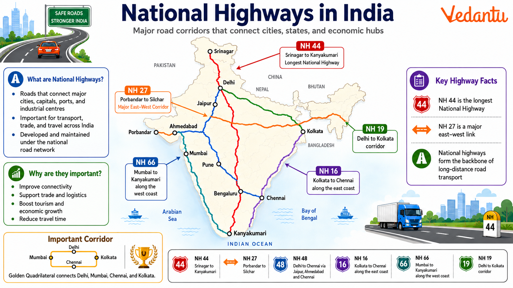
What are National Highways?
National Highways are major roads that are declared and maintained by the Central Government of India. They are managed primarily by the Ministry of Road Transport and Highways and the National Highways Authority of India - NHAI. These highways connect different states and union territories and ensure smooth inter-state transportation.
- Declared under the National Highways Act, 1956
- Constructed and maintained by the Central Government
- Connect major economic and strategic locations
- Identified by unique numbers
Importance of National Highways
National Highways are essential for the overall development of the country. They facilitate trade, transport, and communication between different regions.
- Support economic growth by enabling movement of goods
- Improve connectivity between rural and urban areas
- Enhance national security by connecting border areas
- Promote tourism and regional development
- Generate employment through infrastructure projects
Numbering System of National Highways
In 2010, India adopted a new numbering system for National Highways to make the network more systematic and logical. The numbers are assigned based on the direction and location of the highway.
- Even numbers are assigned to east-west highways
- Odd numbers are assigned to north-south highways
- Smaller numbers are given to highways in the northern and eastern parts
- Larger numbers are assigned as one moves south and west
- Three-digit numbers indicate secondary routes or branches
Major National Highways in India
| Highway Number | Route | Significance |
|---|---|---|
| NH 44 | Srinagar to Kanyakumari | Longest National Highway in India |
| NH 27 | Porbandar to Silchar | Major East-West Corridor |
| NH 48 | Delhi to Chennai | Connects major metropolitan cities |
NH 44 is the longest National Highway in India, stretching from Srinagar in Jammu and Kashmir to Kanyakumari in Tamil Nadu. NH 27 is one of the longest east-west corridors, while NH 48 connects important economic centers like Delhi, Mumbai, Bengaluru, and Chennai.
Longest and Shortest National Highways
- Longest: NH 44 - Approximately 3,745 km
- Shortest: NH 548 - Around 5 km in Maharashtra
Major Highway Development Projects
The Government of India has launched several large-scale projects to modernize and expand the National Highway network.
Golden Quadrilateral
The Golden Quadrilateral connects four major metropolitan cities - Delhi, Mumbai, Chennai, and Kolkata. It forms a quadrilateral shape and is one of the largest highway projects in India.
North-South and East-West Corridors
These corridors connect Srinagar to Kanyakumari and Silchar to Porbandar, improving long-distance connectivity across India.
Bharatmala Pariyojana
Bharatmala Pariyojana is a centrally sponsored scheme aimed at improving freight and passenger movement through the development of economic corridors, border roads, coastal roads, and expressways.
Administration and Maintenance
The development and maintenance of National Highways are managed by the following authorities:
- Ministry of Road Transport and Highways
- National Highways Authority of India - NHAI
- National Highways and Infrastructure Development Corporation Limited - NHIDCL
Key Facts for Competitive Exams
- National Highways form about 2 percent of India's total road network
- They carry around 40 percent of total road traffic
- NH 44 is the longest highway in India
- The new numbering system was introduced in 2010
- Golden Quadrilateral is one of the largest highway projects in the world
Conclusion
National Highways in India are the backbone of the country's road transport system. They connect major cities, promote trade, strengthen defense logistics, and support economic growth. With large-scale projects like the Golden Quadrilateral and Bharatmala Pariyojana, India continues to modernize its highway infrastructure. Understanding the structure, numbering system, major routes, and development projects related to National Highways is essential for students preparing for competitive exams and for anyone interested in India's infrastructure development.
FAQs on National Highways of India: Routes, Network and Importance
1. What are National Highways in India?
National Highways (NHs) are the main arterial roadways that connect major cities, states, ports, and borders across India.
- Managed by the Ministry of Road Transport and Highways (MoRTH)
- Constructed and maintained mainly by the National Highways Authority of India (NHAI)
- Facilitate interstate transport, trade, defense movement, and economic growth
- Form a part of India's core road transport infrastructure network
These highways are crucial for connectivity, logistics, and national integration.
2. Which is the longest National Highway in India?
National Highway 44 (NH 44) is the longest National Highway in India.
- Total length: Around 3,745 km
- Connects Srinagar (Jammu & Kashmir) to Kanyakumari (Tamil Nadu)
- Passes through major states like Punjab, Delhi, Madhya Pradesh, Maharashtra, Telangana, and Karnataka
- Earlier parts included old NH 7
NH 44 plays a vital role in north–south corridor connectivity under the National Highways Development Project (NHDP).
3. Which is the shortest National Highway in India?
National Highway 548 is considered one of the shortest National Highways in India.
- Length: Approximately 5 km
- Located in the state of Maharashtra
- Connects important local transport routes
Short National Highways improve regional connectivity and link smaller areas to the main highway network.
4. How are National Highways numbered in India?
National Highway numbering in India follows a systematic grid-based pattern introduced in 2010.
- Even numbers: East–West direction (e.g., NH 16)
- Odd numbers: North–South direction (e.g., NH 44)
- Smaller three-digit numbers indicate branches or spurs of main highways
- Numbering increases from east to west and north to south
This rationalized system helps in better identification, mapping, and route planning.
5. What is the role of NHAI in National Highways?
The National Highways Authority of India (NHAI) is responsible for the development, maintenance, and management of National Highways.
- Established in 1988
- Implements projects under schemes like Bharatmala Pariyojana and NHDP
- Oversees toll collection and public-private partnerships (PPP)
- Ensures quality control and infrastructure expansion
NHAI plays a key role in strengthening India's highway infrastructure and boosting economic corridors.
6. What is the National Highways Development Project (NHDP)?
The National Highways Development Project (NHDP) was a major highway expansion program launched by the Government of India.
- Started in 1998
- Included the Golden Quadrilateral project
- Developed the North-South and East-West Corridors
- Improved four-laning and six-laning of highways
NHDP significantly enhanced road connectivity, reduced travel time, and promoted national economic development.
7. What is the Golden Quadrilateral in India?
The Golden Quadrilateral is a major highway network connecting four metropolitan cities of India.
- Connects Delhi, Mumbai, Chennai, and Kolkata
- Total length: About 5,846 km
- Part of the NHDP Phase I
- Improves freight movement and industrial growth
It is one of the largest highway infrastructure projects in India and enhances national connectivity.
8. What is Bharatmala Pariyojana?
Bharatmala Pariyojana is a centrally sponsored road and highway development program.
- Launched in 2017
- Focuses on building economic corridors, border roads, and coastal roads
- Aims to improve freight efficiency and logistics performance
- Enhances connectivity to remote and backward regions
This initiative strengthens India's highway network and supports economic integration.
9. How many National Highways are there in India?
India has over 1,400 National Highways covering a vast road network across the country.
- Total length exceeds 1.45 lakh kilometers
- Account for about 2% of total roads but carry nearly 40% of traffic
- Connect state capitals, major ports, and international borders
National Highways form the backbone of India's road transport system and logistics network.
10. Why are National Highways important for India?
National Highways are crucial for India's economic growth, defense, and connectivity.
- Enable fast movement of goods and passengers
- Support trade, tourism, and industrial development
- Improve access to rural and remote areas
- Strengthen national security and disaster response
Overall, National Highways enhance infrastructure development and promote balanced regional growth.