


State-wise List of Major Himalayan and Western Ghats Passes in India
Important Passes in India are strategically and geographically significant mountain routes that connect different regions across the Himalayan, Western Ghats, Eastern Ghats, and other hill ranges. These passes have played a crucial role in trade, cultural exchange, defense, and transportation since ancient times. For students and competitive exam aspirants, knowledge of important mountain passes in India is essential for subjects like Geography and General Studies. This page provides a detailed overview of major passes, their locations, and their importance in a clear and structured format.
What is a Mountain Pass?
A mountain pass is a natural route or gap through a mountain range. It provides a pathway across otherwise difficult terrain and is often used for roads, railways, and trade routes. In India, most important passes are located in the Himalayan region due to its vast mountain system.
Importance of Mountain Passes in India
- Facilitate trade and communication between different regions and countries.
- Serve as strategic military routes for border security.
- Promote tourism and adventure activities.
- Help in cultural exchange between neighboring regions.
- Support transportation networks in hilly and mountainous areas.
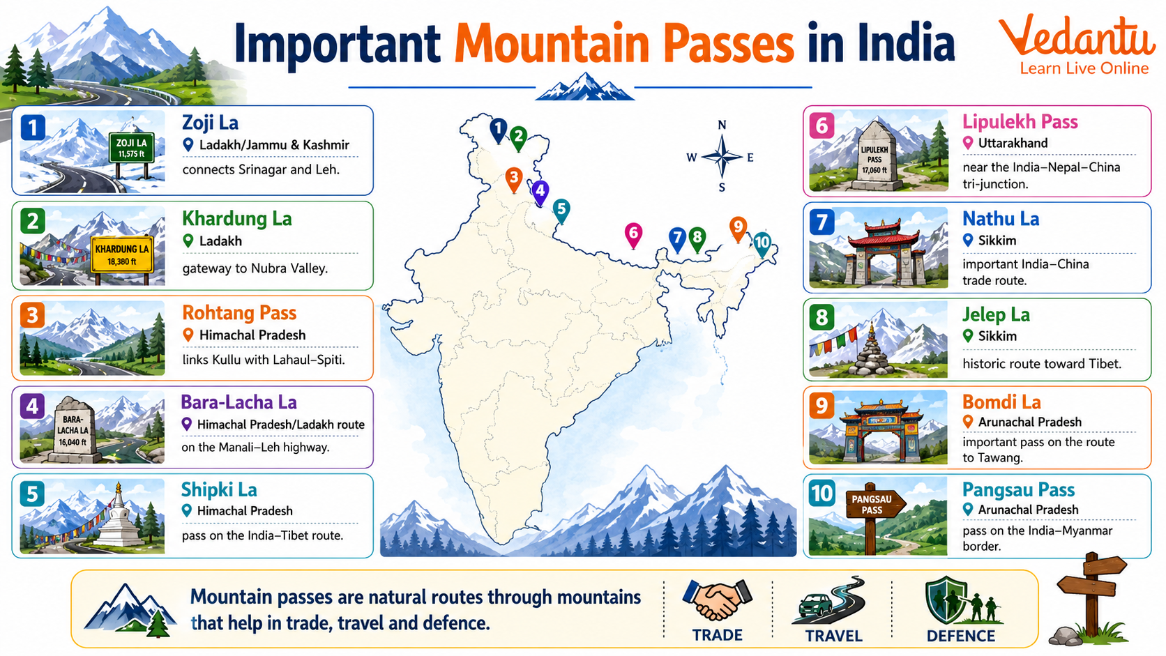
Important Himalayan Passes in India
Major Mountain Passes in India
| Pass | State / Region | Connects / Importance |
|---|---|---|
| Karakoram Pass | Ladakh | India with China, ancient Silk Route |
| Zoji La | Ladakh - Jammu and Kashmir | Srinagar with Leh |
| Nathu La | Sikkim | India with China, trade route |
| Shipki La | Himachal Pradesh | India with China |
| Rohtang Pass | Himachal Pradesh | Kullu Valley with Lahaul and Spiti |
| Bomdi La | Arunachal Pradesh | Arunachal Pradesh with Tibet |
These passes are mainly located in the Himalayan region and are vital for defense, trade, and connectivity. Many of them remain snow covered during winter and are accessible only for limited months.
Other Important Passes in India
Passes in Western Ghats
- Bhor Ghat - Connects Mumbai and Pune.
- Pal Ghat - Connects Kerala and Tamil Nadu.
- Thal Ghat - Connects Mumbai and Nashik.
Passes in Eastern Himalayas
- Jelep La - Connects Sikkim with Tibet.
- Diphu Pass - Tri junction of India, China, and Myanmar.
Strategic and Economic Significance
Mountain passes are crucial for India's national security because many of them lie along international borders. The Indian Army maintains strong presence in several high altitude passes to safeguard the country. Economically, some passes like Nathu La are reopened for trade with China, enhancing bilateral relations and local development.
Mountain Passes Frequently Asked in Exams
- Nathu La - Located in Sikkim.
- Rohtang Pass - Located in Himachal Pradesh.
- Zoji La - Connects Srinagar and Leh.
- Shipki La - Located in Himachal Pradesh.
- Bomdi La - Located in Arunachal Pradesh.
Preparation Tips for Competitive Exams
- Memorize the pass along with the state and connecting regions.
- Focus on passes located on international borders.
- Revise through maps to improve geographical understanding.
- Practice previous year questions related to Indian geography.
Conclusion
Important passes in India are key geographical features that enhance connectivity, defense preparedness, and economic development. Most major passes are located in the Himalayan region and are frequently asked in competitive examinations. A clear understanding of their location, connecting regions, and significance will help students strengthen their General Knowledge and perform better in exams.
FAQs on Important Mountain Passes in India: Complete Guide for Students
1. What are the important mountain passes in India?
The important mountain passes in India are strategic routes through the Himalayan and Western Ghats ranges connecting regions and countries. Key passes include:
• Karakoram Pass – Ladakh (India–China trade route)
• Khyber Pass – Connects Pakistan and Afghanistan (historically linked to India)
• Nathu La Pass – Sikkim (India–China trade route)
• Zoji La Pass – Connects Srinagar to Leh
• Rohtang Pass – Himachal Pradesh
• Shipki La Pass – Himachal Pradesh (India–Tibet)
These Himalayan passes are frequently asked in GK questions, competitive exams, and geography quizzes.
2. Why are mountain passes important in India?
Mountain passes in India are important for trade, defense, and connectivity across difficult terrains. Their significance includes:
• Facilitating international trade routes (e.g., Nathu La)
• Providing strategic military access in border areas
• Connecting remote regions like Ladakh and Arunachal Pradesh
• Supporting tourism and transport in Himalayan states
These passes play a vital role in India’s geography, security, and economic development.
3. Which is the highest mountain pass in India?
The Khardung La Pass in Ladakh is considered one of the highest motorable passes in India. Key facts include:
• Located in Ladakh
• Height: Around 5,359 meters (17,582 feet)
• Connects Leh to Nubra Valley
• Strategic importance for Indian Army logistics
Khardung La is frequently mentioned in GK exams under highest mountain passes in India.
4. Where is Nathu La Pass located?
The Nathu La Pass is located in the state of Sikkim on the India–China border. Important details include:
• Situated at about 4,310 meters above sea level
• Part of the ancient Silk Route
• Opened for border trade between India and China
• Controlled by the Indian Army
Nathu La is commonly asked in geography and current affairs questions.
5. What is the significance of Zoji La Pass?
The Zoji La Pass connects the Kashmir Valley with Ladakh and has major strategic importance. Key points include:
• Located in Jammu and Kashmir
• Connects Srinagar to Leh
• Vital for defense supplies and transportation
• Remains closed during heavy snowfall in winter
Zoji La plays a crucial role in maintaining connectivity to Ladakh.
6. Which mountain pass connects Arunachal Pradesh with Tibet?
The Bomdi La Pass connects Arunachal Pradesh with Tibet (China). Important facts include:
• Located in the Eastern Himalayas
• Connects Tawang with the rest of Arunachal Pradesh
• Important for India–China border security
• Popular in defense and geography GK questions
Bomdi La is significant in understanding India’s northeastern mountain passes.
7. What is the Karakoram Pass known for?
The Karakoram Pass is known for its historical trade and strategic military importance. Key highlights include:
• Located in Ladakh
• Connects India with China (Xinjiang region)
• Part of the ancient Silk Route
• Situated at an altitude of about 5,540 meters
It is one of the highest and most important passes in the Karakoram Range.
8. Which pass connects Manali and Leh?
The Rohtang Pass connects Manali in Himachal Pradesh to Leh in Ladakh. Key features include:
• Located at about 3,978 meters
• Gateway to Lahaul-Spiti and Ladakh
• Important for tourism and transport
• Frequently closed due to heavy snowfall
Rohtang Pass is commonly mentioned in questions about Himachal Pradesh mountain passes.
9. What are the important passes in the Western Ghats?
The important passes in the Western Ghats help connect coastal regions with the Deccan Plateau. Major passes include:
• Thal Ghat – Maharashtra
• Bhor Ghat – Between Mumbai and Pune
• Palghat Gap – Between Kerala and Tamil Nadu
These passes are significant for railway routes, road transport, and regional trade.
10. Which mountain pass is associated with the Indo-China trade route?
The Nathu La Pass and Shipki La Pass are associated with the Indo-China trade route. Important points include:
• Nathu La – Located in Sikkim
• Shipki La – Located in Himachal Pradesh
• Part of the historic Silk Route network
• Important for modern border trade agreements
These passes are frequently covered in GK, UPSC, SSC, and state-level exams.