


Major Types of River Drainage Patterns with Examples
Drainage pattern refers to the arrangement of rivers, streams, and tributaries within a particular drainage basin. It reflects the influence of geological structure, slope, rock type, and climatic conditions of an area. Understanding drainage patterns is important in Geography as it helps explain landform development, river behavior, and surface water distribution. For students and competitive exam aspirants, knowledge of drainage patterns is essential for topics related to geomorphology, Indian rivers, and physical geography.
What is a Drainage Pattern?
A drainage pattern is the geometric arrangement of streams and rivers in a region. It develops over time depending on the nature of the land surface and underlying rock structure. The pattern formed by streams provides valuable clues about geological history and topography.
- It shows how water flows across the landscape.
- It reflects the slope and resistance of rocks.
- It helps identify tectonic and structural controls.
- It is useful in flood management and watershed planning.
Factors Affecting Drainage Pattern
Several natural factors influence the formation of drainage patterns. These factors determine how rivers carve their paths and organize their tributaries.
- Relief and Slope: Steep slopes lead to straight and rapid streams, while gentle slopes form meandering patterns.
- Rock Type: Hard rocks resist erosion, while soft rocks are easily eroded.
- Geological Structure: Faults, folds, and joints guide the direction of streams.
- Climate: Rainfall intensity and distribution affect stream development.
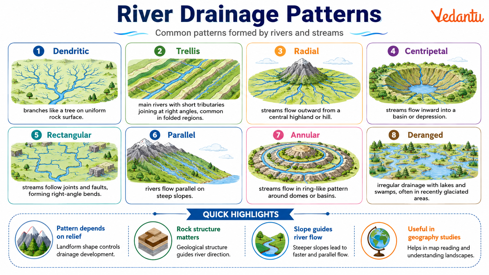
Major Types of Drainage Patterns
1. Dendritic Drainage Pattern
The dendritic pattern resembles the branches of a tree. It develops in regions with uniform rock structure where there is no strong structural control. This is the most common drainage pattern found worldwide.
2. Trellis Drainage Pattern
The trellis pattern forms in regions with alternating layers of hard and soft rocks. Main rivers flow parallel to each other, while tributaries join them at right angles. It is common in folded mountain regions.
3. Radial Drainage Pattern
In radial drainage, streams flow outward from a central elevated point such as a volcano or dome. The rivers spread in all directions like spokes of a wheel.
4. Centripetal Drainage Pattern
Centripetal drainage occurs when streams flow inward toward a central depression or basin. This pattern is found in inland basins and desert regions.
5. Rectangular Drainage Pattern
Rectangular drainage develops in regions with well developed joints or faults. Streams follow the lines of weakness and often make sharp right angle bends.
6. Parallel Drainage Pattern
Parallel drainage forms on steep slopes where streams run almost parallel to each other. It is common in newly uplifted or elongated landforms.
Types of Drainage Patterns and Their Features
| Drainage Pattern | Main Feature | Common Region |
|---|---|---|
| Dendritic | Tree like branching pattern | Uniform rock areas |
| Trellis | Parallel main streams with right angle tributaries | Folded mountains |
| Radial | Streams flow outward from a central high point | Volcanic cones and domes |
| Centripetal | Streams flow inward to a basin | Desert basins |
| Rectangular | Right angle bends due to faults and joints | Faulted regions |
| Parallel | Streams run parallel on steep slopes | Steep or elongated landforms |
Each drainage pattern reveals important information about the underlying geological structure and landform evolution of a region. Recognizing these patterns helps in understanding river systems and landscape development.
Importance of Studying Drainage Patterns
The study of drainage patterns is significant in physical geography and environmental planning. It helps geographers and planners interpret the physical characteristics of an area and manage water resources efficiently.
- Helps in identifying geological structures.
- Useful in watershed management and irrigation planning.
- Assists in flood control and disaster management.
- Important for competitive exams such as UPSC, SSC, and state level exams.
Conclusion
Drainage patterns are a key concept in Geography that explain how rivers and streams are organized across the landscape. Different patterns such as dendritic, trellis, radial, centripetal, rectangular, and parallel develop due to variations in slope, rock type, and geological structure. A clear understanding of drainage patterns helps students grasp geomorphological processes and prepares them effectively for competitive examinations.
FAQs on Drainage Patterns: Meaning, Types and Formation
1. What is a drainage pattern in geography?
A drainage pattern refers to the arrangement of rivers, streams, and tributaries in a particular area. It shows how surface water flows across the land depending on the slope, rock type, and geological structure. Key features include:
• Network of rivers and tributaries
• Influence of topography and relief
• Impact of rock structure and climate
People also ask: What determines drainage patterns? How are drainage systems formed?
2. What are the main types of drainage patterns?
The main types of drainage patterns are classified based on landforms and geological structures. The important types include:
• Dendritic drainage pattern
• Trellis drainage pattern
• Radial drainage pattern
• Rectangular drainage pattern
• Parallel drainage pattern
These patterns are commonly studied in physical geography and competitive exams.
3. What is a dendritic drainage pattern?
A dendritic drainage pattern resembles the branches of a tree and forms on uniform rock surfaces. Its main characteristics are:
• Irregular branching of streams
• Develops on homogeneous rock structures
• Most common drainage type in the world
This pattern is often found in plains and gently sloping regions.
4. What is a trellis drainage pattern?
A trellis drainage pattern forms where hard and soft rocks alternate, creating parallel main streams with right-angle tributaries. Key features include:
• Parallel main rivers
• Tributaries join at nearly 90-degree angles
• Found in folded mountain regions
People also search: Where is trellis drainage found?
5. What is a radial drainage pattern?
A radial drainage pattern develops when rivers flow outward from a central elevated point. Important characteristics are:
• Streams flow in different directions
• Originates from volcanic cones or domes
• Common around hills and mountains
This pattern is shaped mainly by the central highland structure.
6. What factors influence drainage patterns?
Several natural factors determine the formation of a drainage pattern. These include:
• Topography and slope
• Type and structure of rocks
• Climate and rainfall
• Geological disturbances like faults and folds
These factors control how rivers erode land and shape the drainage basin.
7. What is the difference between drainage pattern and drainage system?
A drainage pattern describes the arrangement of streams, while a drainage system refers to the main river and its tributaries forming a network. Key differences:
• Pattern = Shape or design of flow
• System = Entire river network
• Pattern depends on land structure
This distinction is important in geography exams and map studies.
8. What is a rectangular drainage pattern?
A rectangular drainage pattern forms in regions with jointed or fractured rocks. Its features include:
• Streams follow straight courses
• Tributaries meet at right angles
• Controlled by faults and cracks in rocks
This pattern is influenced mainly by geological structures rather than slope.
9. Why is the study of drainage patterns important?
The study of drainage patterns helps in understanding landforms and water resources. Its importance includes:
• Identifying geological history
• Planning irrigation and water management
• Predicting flood risks
• Supporting environmental and urban planning
It is a key topic in geography and general knowledge.
10. What is a parallel drainage pattern?
A parallel drainage pattern forms when streams flow parallel to each other due to a steep slope. Its main features are:
• Rivers run in the same direction
• Develops on uniform, steep surfaces
• Common in newly uplifted landforms
People also ask: What causes parallel drainage? Where is it found?