


Class 11 Geography Chapter 4 Climate Important Questions with Answers PDF
Practise 20 chapter-based questions covering India's monsoon system, seasons, rainfall patterns, and climatic differences. Each Class 11 Geography Chapter 4 Climate Important Question Answer explains the concept with examples, while MCQs and map-based exercises help students prepare for exams.
Class 11 Geography Chapter 4 MCQs with Answers
Q1. Agra and Darjeeling are located at nearly the same latitude, yet Darjeeling is much colder in January. What is the main reason?
(a) Darjeeling receives no sunlight during winter.
(b) Darjeeling is located at a higher altitude.
(c) Agra lies closer to the Equator.
(d) Agra receives more snowfall than Darjeeling.
Answer: (b) Darjeeling is located at a higher altitude.
Explanation: Temperature generally decreases with increasing altitude. The chapter gives January temperatures of approximately 16°C in Agra and 4°C in Darjeeling to illustrate how height influences climate, even at similar latitudes.
Q2. During July, the Inter-Tropical Convergence Zone (ITCZ) shifts northwards over the Gangetic Plain. What is this low-pressure belt commonly called?
(a) Western disturbance
(b) Monsoon trough
(c) Subtropical high-pressure belt
(d) Polar front
Answer: (b) Monsoon trough.
Explanation: During July, the ITCZ shifts towards approximately 20°–25° N over the Gangetic Plain. This low-pressure belt is called the monsoon trough and plays an important role in attracting moisture-bearing winds towards India.
Q3. Why does Pune receive much less rainfall than places on the western slopes of the Western Ghats during the southwest monsoon?
(a) Pune receives only polar winds.
(b) Pune lies in the rain-shadow region of the Western Ghats.
(c) Rain-bearing winds never cross the Arabian Sea.
(d) Pune is located beyond the Himalayas.
Answer: (b) Pune lies in the rain-shadow region of the Western Ghats.
Explanation: Moist Arabian Sea winds rise along the western slopes of the Western Ghats and release considerable rainfall. After crossing the mountains, the winds descend, become warmer and contain less moisture, producing drier conditions towards Pune.
Q4. Which seasonal wind system is mainly responsible for rainfall along the Tamil Nadu coast during October and November?
(a) Southwest monsoon directly from the Arabian Sea
(b) Northeasterly monsoon winds crossing the Bay of Bengal
(c) Cold polar winds from Central Asia
(d) Hot, dry Loo winds
Answer: (b) Northeasterly monsoon winds crossing the Bay of Bengal.
Explanation: During the retreating monsoon period, northeasterly winds acquire moisture while crossing the Bay of Bengal. They, along with associated cyclonic systems, bring rainfall to the Tamil Nadu coast.
Q5. Farmers in West Bengal welcome certain violent pre-monsoon thunderstorms because their rainfall benefits tea, jute and rice cultivation. What are these storms called?
(a) Mango showers
(b) Loo
(c) Kalbaisakhi or Nor'westers
(d) Western disturbances
Answer: (c) Kalbaisakhi or Nor'westers.
Explanation: Nor'westers are strong local thunderstorms experienced in Bengal and Assam during the hot weather season. They are called Kalbaisakhi in Bengal and Bardoisila in Assam. Their rainfall benefits certain crops despite the storms' destructive potential.
Class 11 Geography Chapter 4 Very Short Answer Questions
Q6. What is the difference between weather and climate?
Answer: Weather describes atmospheric conditions at a particular time, while climate refers to the average weather conditions of a place over a long period. Weather can change within hours or days, whereas climate changes much more slowly.
Q7. What are western disturbances, and where do they originate?
Answer: Western disturbances are cyclonic systems that originate around the Mediterranean region and travel eastwards towards northwestern India. They bring winter rainfall to parts of northern India and snowfall to the Himalayas.
Q8. What is meant by 'October heat' in India?
Answer: October heat refers to the hot, humid and uncomfortable weather experienced during the retreating monsoon season. The skies often become clear, but moisture remains in the land and atmosphere, making conditions oppressive.
Q9. What is a break in the monsoon?
Answer: A break in the monsoon is a dry spell lasting one or more weeks during the southwest monsoon season, after an earlier period of rainfall. It can occur because rain-bearing weather systems become less active over a region.
Class 11 Geography Chapter 4 Short Answer Questions
Q10. Why does India have a monsoon climate even though Rajasthan, Meghalaya, Ladakh and coastal Kerala experience very different weather conditions?
Answer: India has a broadly monsoonal climate because seasonal changes in wind direction influence much of the country. However, temperature and rainfall vary considerably between regions.
1. Western Rajasthan: Summers can be extremely hot, with temperatures occasionally approaching 50°C or more.
2. Ladakh: Winter temperatures can fall far below freezing, particularly in places such as Drass.
3. Meghalaya: Mawsynram and Cherrapunji receive exceptionally heavy rainfall because of the moisture-bearing winds and surrounding hills.
4. Jaisalmer: The region receives very little annual rainfall because of its dry location and regional climatic conditions.
5. Coastal Kerala: Its proximity to the sea helps moderate temperatures, resulting in a smaller difference between summer and winter conditions.
6. Common Monsoon Influence: Despite these differences, seasonal changes in winds and rainfall affect the country's overall climatic rhythm.
Comparison of Climatic Conditions
Conclusion: India's monsoon climate shows both unity and diversity. The broad seasonal pattern is shared, but local conditions differ because of altitude, relief, distance from the sea and other factors.
Q11. How do latitude, altitude, distance from the sea and the Himalayas influence the climate of India?
Answer: India's climate is influenced by several geographical factors that affect temperature, rainfall and seasonal conditions.
1. Latitude: The Tropic of Cancer divides India into tropical and subtropical regions. Southern areas generally experience higher temperatures and smaller annual temperature differences.
2. Altitude: Higher places are generally cooler because temperature decreases with height. This explains why Darjeeling is colder than Agra despite their similar latitudes.
3. Distance from the Sea: Coastal areas experience more moderate temperatures because water heats and cools slowly. Interior places such as Delhi and Amritsar experience greater seasonal differences.
4. Himalayan Mountains: The Himalayas restrict the entry of extremely cold winds from Central Asia and obstruct moisture-bearing monsoon winds, causing rainfall.
5. Land and Water Distribution: Land heats and cools faster than the sea. These seasonal temperature differences help create pressure conditions associated with monsoon winds.
6. Relief: Mountains influence rainfall by forcing moist winds to rise. The windward slopes of the Western Ghats receive heavy rainfall, while areas on the leeward side receive less.
Conclusion: India's regional climatic differences result from the combined influence of location, height, surrounding seas and physical landforms.
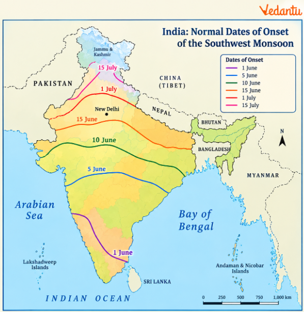
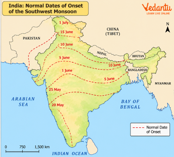
(a) Around which date does the southwest monsoon normally reach Kerala?
Answer: Around 1 June.
(b) Around which date does the monsoon normally reach Mumbai?
Answer: Around 10 June.
(c) Which part of India generally receives the southwest monsoon earlier: the southern peninsula or northwestern India?
Answer: The southern peninsula receives the southwest monsoon earlier than northwestern India.
(d) By approximately when does the southwest monsoon normally cover most of the Indian subcontinent?
Answer: By the middle of July, according to the chapter.
(e) What do the curved lines labelled with dates represent on the map?
Answer: They show the normal progression of the southwest monsoon's arrival over different regions.
(f) Why does the monsoon not reach all parts of India on the same date?
Answer: Monsoon winds advance through different routes and are influenced by landforms, pressure conditions and the Arabian Sea and Bay of Bengal branches.
Map-learning point: The dates represent the normal onset pattern, not guaranteed dates for every year. The monsoon may arrive earlier or later depending on atmospheric conditions.
Q13. Compare mango showers, blossom showers, Nor'westers and Loo. How do these local weather conditions affect people and agriculture?
Answer: Different parts of India experience distinctive weather events during the hot weather season, especially before the southwest monsoon arrives.
Explanation: Mango and blossom showers provide moisture before the main monsoon season. Nor'westers may bring heavy rain, thunderstorms and strong winds. In contrast, the Loo is a hot, dry wind that raises the intensity of summer heat in northern India.
Conclusion: Local weather events can have both helpful and harmful effects, depending on their intensity and the region where they occur.
Q14. How do jet streams and El Niño influence the onset and variability of the Indian monsoon?
Answer: The Indian monsoon depends on several atmospheric processes. Jet streams and El Niño are important factors as important factors associated with monsoon behaviour.
1. Westerly Jet Stream: During winter, the westerly jet stream influences weather conditions over northern India, including the movement of western disturbances.
2. Seasonal Withdrawal: Before the summer monsoon becomes established, the westerly jet stream withdraws from its position south of the Himalayas.
3. Easterly Jet Stream: The easterly jet stream develops during summer. The textbook associates its establishment with the onset or burst of the monsoon.
4. El Niño: El Niño is an ocean-atmosphere phenomenon involving unusually warm surface waters in the eastern equatorial Pacific.
5. Atmospheric Circulation: Changes in Pacific Ocean conditions can influence large-scale atmospheric circulation and affect rainfall patterns in different regions, including India.
6. Monsoon Variability: The chapter explains that El Niño-related information is used in long-range monsoon forecasting. It cites 1990–91 as a period when monsoon onset was delayed over many parts of India.
Conclusion: Jet streams help explain seasonal atmospheric changes, while El Niño is one factor that can influence year-to-year monsoon variability. Neither factor alone explains every change in India's rainfall.
Class 11 Geography Chapter 4 Long Answer Questions
Q15. Explain the mechanism of the Indian southwest monsoon. How do differential heating, the ITCZ, pressure differences and the Coriolis force influence monsoon winds?
Answer: The southwest monsoon develops through seasonal changes in temperature, air pressure and atmospheric circulation. These changes draw moisture-bearing winds from the oceans towards India.
1. Differential Heating of Land and Sea
During April and May, the Indian landmass heats up faster than the surrounding seas.
This creates differences in temperature and air pressure between the land and ocean.
2. Development of Low Pressure
Intense summer heating produces a low-pressure region over northwestern India.
This low pressure attracts winds from the relatively higher-pressure region over the southern Indian Ocean.
3. Role of the ITCZ
The Inter-Tropical Convergence Zone is a low-pressure belt where trade winds converge, and air rises.
During summer, it shifts northwards over the Indian subcontinent.
4. Formation of the Monsoon Trough
In July, the ITCZ is located around 20°–25° N over the Gangetic Plain.
This low-pressure belt is called the monsoon trough.
5. Movement of Southeast Trade Winds
Trade winds from the Southern Hemisphere move towards the low-pressure region over India.
6. Crossing the Equator
These winds cross the Equator, particularly between 40° E and 60° E longitude, as described in the chapter.
7. Effect of the Coriolis Force
After crossing the Equator, the winds are deflected towards the right in the Northern Hemisphere.
They begin blowing from the southwest towards the northeast.
8. Formation of Southwest Monsoon Winds
The deflected winds become the southwest monsoon.
9. Moisture from Warm Ocean Waters
As these winds travel over the Arabian Sea and Bay of Bengal, they carry substantial moisture.
10. Role of the Himalayas
The Himalayas obstruct the movement of moist winds towards the north and force air to rise.
This supports rainfall across parts of the subcontinent.
11. Role of Jet Streams
The withdrawal of the westerly jet stream and the establishment of the easterly jet stream are associated with the monsoon's onset.
12. Beginning of Rainfall
Once moisture-bearing winds reach the mainland, rainfall can begin rapidly, producing the familiar arrival or burst of the monsoon.
Stages in Monsoon Development
Conclusion: The southwest monsoon develops through the combined influence of seasonal heating, pressure differences, ITCZ movement, cross-equatorial winds and atmospheric circulation.
Q16. Describe the Arabian Sea and Bay of Bengal branches of the southwest monsoon. Why do they produce different rainfall patterns across India?
Answer: The southwest monsoon reaches India through two main branches: the Arabian Sea branch and the Bay of Bengal branch.
Their direction and rainfall distribution are influenced by mountain ranges, regional pressure systems and the arrangement of India's landforms.
Part A: Arabian Sea Branch
1. Arrival on the Western Coast: The Arabian Sea branch reaches the western coast of India around the beginning of June.
2. Western Ghats Barrier: Moist winds are obstructed by the Western Ghats and forced to rise along their western slopes.
3. Heavy Windward Rainfall: As the air rises and cools, moisture condenses and produces substantial rainfall. The chapter describes rainfall of approximately 250–400 cm in parts of the Western Coastal Plain and windward Sahyadris.
4. Rain-Shadow Effect: After crossing the Western Ghats, winds descend and warm up. The lower humidity produces less rainfall east of the mountains, including parts of the Deccan Plateau.
5. Central Indian Branch: Another branch strikes the coast north of Mumbai and advances along the Narmada and Tapi valleys. It contributes to rainfall over parts of central India before meeting the Bay of Bengal branch.
6. Saurashtra and Kachchh Branch: A third branch moves towards Saurashtra and Kachchh.It passes over western Rajasthan and the Aravallis, producing comparatively little rainfall before moving farther north.
Part B: Bay of Bengal Branch
7. Arrival Near Myanmar and Bangladesh: The Bay of Bengal branch reaches the coast of Myanmar and southeastern Bangladesh.
8. Role of the Arakan Hills:The Arakan Hills redirect a considerable part of these winds towards the Indian subcontinent.
9. Entry into West Bengal: The winds reach West Bengal and Bangladesh from the south and southeast.
10. Movement Along the Ganga Plain: One branch advances westwards along the Ganga Plain towards northwestern India.
11. Movement Through the Brahmaputra Valley: Another branch moves north and northeast through the Brahmaputra Valley.
12. Khasi and Garo Hills: A sub-branch strikes the hills of Meghalaya and produces exceptionally heavy rainfall.
13. Mawsynram: Mawsynram in the Khasi Hills receives exceptionally high average annual rainfall because of the region's geographical setting and moist winds.
14. Why Tamil Nadu Remains Comparatively Dry in Summer: Two main reasons explain this: the Tamil Nadu coast lies nearly parallel to the Bay of Bengal branch, and it is situated in the rain-shadow region of the Arabian Sea branch.
Comparison of the Two Monsoon Branches
Conclusion: The two monsoon branches bring moisture to different parts of India, while mountains and regional pressure conditions create variations in rainfall.
Q17. Study Figure 4.3 – India: Seasonal Rainfall (June–September). Explain the regional rainfall differences shown on the map.
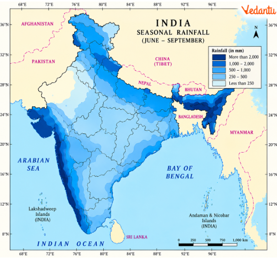
Answer: The map illustrates that rainfall during June–September is not distributed equally across India. Some regions receive very heavy rainfall, while others remain comparatively dry.
1. Western Coastal Plain
The western coastal belt receives heavy rainfall because moisture-laden Arabian Sea winds reach it directly.
2. Western Ghats
The western slopes of the Western Ghats force moist air to rise, producing orographic rainfall.
3. Rain-Shadow Region
Areas to the east of the Western Ghats receive less rainfall because winds lose moisture before descending onto the plateau.
4. Northeastern India
Parts of northeastern India receive high rainfall from the Bay of Bengal branch.
5. Meghalaya Hills
The Khasi and adjoining hills experience exceptionally heavy rainfall where moist winds are forced to rise.
6. Ganga Plain
Rainfall generally decreases as the Bay of Bengal branch travels westwards across the Northern Plain.
7. Western Rajasthan
Much of western Rajasthan receives low rainfall during the southwest monsoon.
8. Tamil Nadu Coast
The Tamil Nadu coast receives comparatively less rainfall during this season because of its location relative to the two monsoon branches.
9. Himalayan Foothills
Parts of the Himalayan foothills receive rainfall as moist winds rise over elevated terrain.
10. Seasonal Concentration
The map represents rainfall during the four main southwest monsoon months rather than the entire year's precipitation.
Map-Based Questions
(a) Which two broad regions show some of the highest June–September rainfall?
Answer: The western coastal and Western Ghats region, and parts of northeastern India, particularly Meghalaya.
(b) Why does the interior Deccan receive less rainfall than the western slopes of the Western Ghats?
Answer: The interior Deccan lies on the leeward side of the Western Ghats and experiences rain-shadow conditions.
(c) Why does rainfall generally decrease across the Northern Plain from east to west?
Answer: Moisture-bearing winds of the Bay of Bengal branch progressively lose moisture as they travel inland.
(d) Which region shown on the map receives relatively low southwest monsoon rainfall but substantial rainfall later in the year?
Answer: The Tamil Nadu coast.
(e) What is the difference between seasonal and annual rainfall maps?
Answer: A seasonal rainfall map shows rainfall during a particular period, whereas an annual rainfall map represents the total rainfall received over a year.
Conclusion: Figure 4.3 demonstrates the importance of relief, wind direction and distance travelled by monsoon winds in shaping India's seasonal rainfall distribution.
Q18. Study Figure 4.4 – India: Annual Rainfall. Explain why rainfall varies so much between Meghalaya, western Rajasthan, the Western Ghats and the Deccan Plateau.
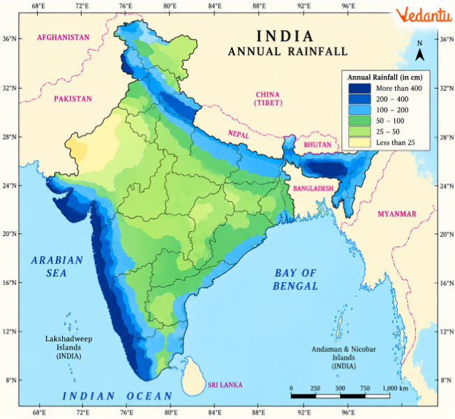
Answer: India's average annual rainfall is approximately 125 cm according to the chapter, but the actual amount varies significantly between regions. The distribution depends on monsoon winds, relief, distance from the sea and location.
1. High Rainfall Along the West Coast
Areas along the Western Ghats receive very heavy rainfall because the Arabian Sea branch rises over the mountain slopes.
2. High Rainfall in Meghalaya
The Khasi and Jaintia Hills receive heavy rainfall when moisture-bearing winds are forced to rise.
3. Northeastern Region
Parts of northeastern India receive abundant rainfall from the Bay of Bengal branch.
4. Moderate Rainfall Regions
Several areas in eastern and central India receive approximately 100–200 cm of annual rainfall.
5. Northwestern Plains
Parts of Punjab, Haryana, Delhi and western Uttar Pradesh receive comparatively less rainfall.
6. Western Rajasthan
The arid region of western Rajasthan receives very little rainfall because of unfavourable conditions for widespread moisture-bearing rainfall.
7. Interior Deccan Plateau
Parts of Maharashtra, Karnataka and Andhra Pradesh receive low rainfall because they lie in the rain-shadow region of the Western Ghats.
8. Tamil Nadu Coast
Tamil Nadu receives important rainfall during the retreating monsoon, which contributes to its annual total.
9. Himalayan Region
Higher Himalayan areas receive precipitation in the form of snowfall as well as rainfall.
10. Influence of Relief
Mountains can increase rainfall on windward slopes and create drier conditions on leeward slopes.
Annual Rainfall Categories
Map-Based Questions
(a) Which regions receive more than 200 cm of annual rainfall?
Answer: Parts of the Western Ghats, the western coast and northeastern India, including the Meghalaya hills.
(b) Which region receives less than 50 cm of annual rainfall?
Answer: Much of western Rajasthan, Ladakh and some interior Peninsular regions.
(c) Why does the Deccan Plateau receive less rainfall than the western coast?
Answer: Much of the interior Deccan lies in the rain-shadow region of the Western Ghats.
(d) Why is annual rainfall different from rainfall during June–September?
Answer: Annual rainfall includes precipitation from all seasons, including the southwest monsoon, retreating monsoon and winter weather systems.
(e) How does the rainfall map help explain regional differences in agriculture?
Answer: It helps identify areas with abundant rainfall and those where irrigation or water conservation may be more important for farming.
Conclusion: India's annual rainfall pattern reflects the combined influence of monsoon winds, topography and seasonal weather conditions. Regional differences affect water availability and agricultural activities.
Q19. Describe the four seasons recognised by Indian meteorologists. How do temperature, winds and rainfall change during each season?
Answer: India's monsoon climate follows a seasonal cycle. Indian meteorologists recognise four main seasons based on changes in temperature, air pressure, wind direction and rainfall.
Part A: Cold Weather Season
1. Period: The cold weather season begins around mid-November in northern India. December and January are generally the coldest months in the Northern Plain.
2. Temperature: Temperatures fall considerably across northern India, while coastal and Peninsular regions experience comparatively mild conditions.
3. Winter Pressure Conditions: High-pressure conditions develop over much of northern India, and winds generally blow from land towards the surrounding seas.
4. Western Disturbances: Cyclonic systems originating around the Mediterranean region bring winter rainfall to northwestern India and snowfall to parts of the Himalayas.
5. Importance for Agriculture: Winter rainfall is valuable for rabi crops such as wheat.
Part B: Hot Weather Season
6. Period: March to June is the main hot weather season in northern India.
7. Rising Temperatures: Temperatures rise as the Sun's apparent position moves northwards.
8. Summer Heat in Northwestern India: Temperatures may become very high in Rajasthan, Punjab, Haryana and neighbouring regions.
9. Loo Winds: Hot, dry winds called Loo blow across parts of the Northern Plains.
10. Local Thunderstorms: Mango showers, blossom showers and Nor'westers occur in different parts of India.
11. Development of Low Pressure: Intense heating over northern and northwestern India helps create the low-pressure conditions associated with the incoming monsoon.
Part C: Southwest Monsoon Season
12. Period: The southwest monsoon generally begins over Kerala around 1 June and extends across most of India by mid-July.
13. Moisture-Bearing Winds: Winds from the Arabian Sea and Bay of Bengal carry moisture towards the subcontinent.
14. Heavy Rainfall: The western coastal region, Western Ghats and parts of northeastern India receive substantial rainfall.
15. Regional Differences: Rainfall varies because of the movement of the monsoon branches, landforms and rain-shadow regions.
16. Breaks in the Monsoon: Some areas experience dry spells lasting one or more weeks during the rainy season.
Part D: Retreating Monsoon Season
17. Period: The retreating monsoon is particularly associated with October and November.
18. Withdrawal of the Southwest Monsoon: As the low-pressure region shifts southwards, southwest monsoon winds gradually withdraw from India.
19. October Heat: Clear skies and high humidity can produce uncomfortable conditions, especially early in the season.
20. Rainfall Along the Eastern Coast: The eastern coast of southern India receives rainfall from retreating monsoon winds and cyclonic systems.
21. Tropical Cyclones: Cyclonic depressions developing over the Andaman Sea and Bay of Bengal can bring heavy rainfall and damaging winds to the eastern coastal plains.
22. Tamil Nadu's Rainfall: October and November are particularly important rainfall months for the Tamil Nadu coast.
Comparison of India's Four Seasons
Conclusion: India's four seasons reflect changes in temperature, pressure and wind circulation. Their timing and intensity vary between northern, southern, coastal and mountainous regions.
Q20. Why is the Indian monsoon important for agriculture and everyday life? Explain how rainfall variability and global warming can affect the country's environment and economy.
Answer: The monsoon strongly influences India's agriculture, water resources and daily activities. Although different regions experience different climatic conditions, seasonal rainfall is important across much of the country.
Part A: Importance of the Monsoon
1. Agricultural Activities
A large part of Indian agriculture depends on the availability and timing of monsoon rainfall.
2. Kharif Crops
Crops such as rice depend heavily on moisture received during the rainy season.
3. Rabi Crops
Winter rainfall brought by western disturbances can benefit crops such as wheat.
4. Water Resources
Monsoon rainfall contributes to the water available in rivers, reservoirs, lakes and groundwater systems.
5. Regional Crop Diversity
Differences in rainfall and temperature allow different crops to grow in different regions.
6. Everyday Life
Climatic conditions influence clothing, housing, working conditions and the timing of certain activities.
Part B: Problems Caused by Rainfall Variability
7. Delayed Monsoon
A delayed onset can postpone sowing and create difficulties for farmers.
8. Insufficient Rainfall
Weak rainfall can produce drought-like conditions, especially in areas without reliable irrigation.
9. Excess Rainfall
Intense rainfall can cause flooding, erosion and damage to crops and infrastructure.
10. Uneven Distribution
Some areas may experience floods while others face water shortages during the same season.
11. Sudden Monsoon Burst
Heavy rainfall at the beginning of the monsoon can increase surface runoff and soil erosion.
Part C: Global Warming and Climate Change
12. Greenhouse Gases
Greenhouse gases include carbon dioxide, methane, chlorofluorocarbons and nitrous oxide.
13. Human Activities
Burning fossil fuels, industrial activity and the release of greenhouse gases contribute to global warming.
14. Rising Temperatures
An increase in global temperatures can affect climatic conditions, water resources and ecosystems.
15. Melting of Glaciers and Ice
Warming contributes to ice loss, which can affect sea levels and water systems.
16. Coastal Impacts
Sea-level rise can increase flooding risks in low-lying coastal areas.
17. Changes in Rainfall
Climate change can influence the distribution and intensity of rainfall, with some regions becoming wetter or drier.
18. Agricultural Impacts
Changes in temperature and rainfall can affect crop-growing conditions and agricultural productivity.
19. Environmental Changes
Shifts in climatic conditions can affect natural vegetation, ecosystems and the distribution of some diseases.
20. Need for Adaptation
Better water management, soil conservation, climate information and suitable agricultural practices can help communities respond to climatic changes.
Monsoon Conditions and Their Effects
Conclusion: The monsoon is essential to India's environmental and economic life, but its variability creates challenges. Understanding rainfall patterns and climate change helps explain the importance of water conservation and adaptation.
Why Practise Class 11 Geography Chapter 4 Important Questions with Vedantu?
Vedantu's Climate Important Questions help students revise monsoon winds, seasonal changes and rainfall patterns through detailed answers and map practice.
How to Prepare Class 11 Geography Chapter 4 Important Questions?
Revise concepts: Focus on climatic factors and monsoon formation.
Compare seasons: Understand changes in temperature, winds and rainfall.
Practise maps: Study Figures 4.2–4.4.
Use examples: Revise regional rainfall differences and local storms.
Important Study Material Links for Class 11 Geography Chapter 4
CBSE Class 11 Geography Other Books Important Questions and Study Resources
Chapter-Wise Important Questions for Class 11 Geography – India: Physical Environment
After practising Chapter 4 Climate Important Questions, students can continue with other chapters of India: Physical Environment to learn about the country's geographical location, physical divisions, drainage systems, vegetation and natural hazards.
Important Study Materials for Class 11 Geography
FAQs on Important Questions and Answers for Class 11 Geography Chapter 4 – Climate (India: Physical Environment) | 2026-27
1. Which topics are most important in Class 11 Geography Chapter 4: Climate?
Focus on the factors affecting India's climate, the ITCZ, monsoon formation, jet streams, the four seasons and rainfall distribution. Questions about the Western Ghats, Meghalaya, Tamil Nadu and rainfall distribution maps are also useful for revision.
2. Why does Delhi have very hot summers and cold winters, but Mumbai has more moderate temperatures?
Delhi is located inland, away from the moderating influence of the sea. Land heats and cools faster, so Delhi experiences greater seasonal temperature differences. Mumbai is close to the Arabian Sea, where water heats and cools more slowly, helping keep temperatures comparatively moderate.
3. Why does Tamil Nadu receive most of its important seasonal rainfall later than many other parts of India?
Tamil Nadu receives substantial rainfall during October and November from the northeast or retreating monsoon. These winds collect moisture while passing over the Bay of Bengal. Cyclonic depressions also bring rainfall to the coast, whereas the southwest monsoon produces comparatively less rainfall in much of the region.
4. What is the difference between the Arabian Sea and Bay of Bengal branches of the monsoon?
The Arabian Sea branch reaches western India and produces heavy rainfall along the Western Ghats. The Bay of Bengal branch influences eastern, northeastern and northern India. Mountain ranges, wind directions and low-pressure conditions affect how each branch moves and distributes rainfall.
5. Why does Mawsynram receive very heavy rainfall while western Rajasthan remains dry?
Mawsynram lies in the Khasi Hills, where moist winds are forced to rise and produce heavy rainfall. Western Rajasthan experiences different wind and relief conditions and receives much less moisture-bearing rainfall. This comparison shows why relief and wind direction are important for understanding India's climate.
6. What does the ITCZ have to do with the arrival of the southwest monsoon?
During summer, the ITCZ shifts northwards as the Indian landmass becomes hotter. Its low-pressure conditions help draw winds from the Southern Hemisphere towards India. After crossing the Equator, these winds change direction and contribute to the southwest monsoon.
7. Why does the monsoon sometimes stop raining for several days even though the rainy season has started?
This is called a break in the monsoon. In northern India, it can occur when rain-bearing storms become less frequent along the monsoon trough. Along the western coast, dry spells may occur when winds blow parallel to the coastline rather than producing strong rainfall over the Western Ghats.
8. Do mango showers, blossom showers and Nor'westers occur during the same season?
Yes. They occur during the hot weather or pre-monsoon season, although in different regions. Mango showers are associated with parts of Kerala and Karnataka, blossom showers help coffee flowers bloom, and Nor'westers bring thunderstorms to Bengal and Assam. Their rainfall can be useful for agriculture.
9. How do western disturbances help farmers in northern India?
Western disturbances bring light winter rainfall to parts of northwestern India. This rainfall provides moisture for rabi crops, especially wheat. They also cause snowfall in the Himalayas, contributing to mountain snow accumulation and river-water supplies.
10. Where can I find Class 11 Geography Chapter 4 Climate question answers with climate maps?
This Class 11 Geography Chapter 4 Climate Question Answer set includes solved questions and map-based practice using Figures 4.2, 4.3 and 4.4. These maps cover monsoon onset, seasonal rainfall and annual rainfall distribution across India.
11. Are Class 11 Geography India Physical Environment Chapter 4 Important Questions useful for understanding the monsoon mechanism?
Yes. Questions on differential heating, the ITCZ, Coriolis force, jet streams and seasonal pressure differences help explain how the monsoon develops. Practising these concepts together is more useful than memorising only the dates of monsoon onset and withdrawal.
12. How can I prepare long answers on Indian climate without memorising every paragraph?
Organise each answer around a few connected ideas. For example, explain the monsoon mechanism in the sequence of land heating, low pressure, ITCZ movement, cross-equatorial winds and rainfall. For regional rainfall questions, connect wind direction, relief and rain-shadow conditions with specific places. Use short paragraphs, examples and labelled maps where relevant.