


Class 11 Geography Chapter 1 India - Location Important Questions with Answers PDF
This Class 11 Geography India Physical Environment Chapter 1 practice set includes 20 solved questions: five MCQs, four very short answers, five short answers, and six long answers. The questions follow the prescribed 2026–27 chapter, including its maps, distance figures, and explanations of India's time zone, the Indian subcontinent, island groups, and maritime connections.
Class 11 Geography Chapter 1 MCQs with Answers
Q1. India's mainland extends across nearly 30° of both latitude and longitude. Why is its north-south distance greater than its east–west distance?
(a) Latitudes become shorter towards the poles.
(b) The distance between longitudes decreases towards the poles.
(c) Longitudes are parallel to the Equator.
(d) India's southern coastline extends farther into the sea.
Answer: (b) The distance between longitudes decreases towards the poles.
Explanation: Lines of latitude are parallel, while lines of longitude converge towards the poles. Therefore, a degree of longitude represents a shorter distance on the ground at higher latitudes. This helps explain why India's north–south extent is approximately 3,214 km, compared with its east–west extent of 2,933 km.
Q2. A student in Imphal notices that the Sun rises much earlier than in Jaisalmer, but the clocks in both places show Indian Standard Time. Which longitude is used to maintain this common time?
(a) 68°7′ E
(b) 75° E
(c) 82°30′ E
(d) 97°25′ E
Answer: (c) 82°30′ E.
Explanation: India follows the local mean time of 82°30′ E longitude as Indian Standard Time (IST). This ensures that places across the country use one standard time despite differences in their local sunrise and sunset timings.
Q3. According to the chapter, India's southern boundary extends to approximately 6°45′ N because of which geographical feature?
(a) Kanniyakumari
(b) Lakshadweep Islands
(c) Nicobar Islands
(d) Gulf of Mannar
Answer: (c) Nicobar Islands.
Explanation: India's southernmost extent lies in the Nicobar Islands. India's mainland ends farther north at Kanniyakumari, but the country's total geographical extent includes its island territories.
Q4. Which geographical feature separates Sri Lanka from the Indian mainland?
(a) Strait of Malacca and Bay of Bengal
(b) Palk Strait and Gulf of Mannar
(c) Gulf of Kachchh and Arabian Sea
(d) Gulf of Khambhat and Indian Ocean
Answer: (b) Palk Strait and Gulf of Mannar.
Explanation: The Palk Strait and Gulf of Mannar separate Sri Lanka from India. They are important for understanding India's southern maritime geography.
Q5. Why does India's south-central location in Asia provide an advantage for international connections?
(a) India is surrounded by land.
(b) The Himalayas prevent all foreign contact.
(c) The Indian peninsula provides access to the Indian Ocean and important sea routes.
(d) India lies entirely within the temperate zone.
Answer: (c) The Indian peninsula provides access to the Indian Ocean and important sea routes.
Explanation: India's peninsular location gives it access to the Arabian Sea, Bay of Bengal and the wider Indian Ocean. These water bodies support connections with neighbouring regions through maritime routes, as shown in Figure 1.2.
Class 11 Geography Chapter 1 Very Short Answer Questions
Q6. What are the latitudinal and longitudinal extents of mainland India?
Answer: Mainland India extends approximately from 8°4′ N to 37°6′ N latitude and 68°7′ E to 97°25′ E longitude. This gives India a spread of nearly 30° in both directions.
Q7. Why is Indian Standard Time 5 hours and 30 minutes ahead of Greenwich Mean Time?
Answer: India uses 82°30′ E as its standard meridian. Since Earth rotates 15° of longitude per hour, 82.5° corresponds to 5 hours and 30 minutes. Therefore, IST is GMT+5:30.
Q8. What does it mean that India's territorial waters extend up to 12 nautical miles?
Answer: India's territorial waters extend up to 12 nautical miles from its coastal baselines. The chapter describes this distance as approximately 21.9 km. These waters form part of India's territorial area.
Q9. Which countries are identified as part of the Indian subcontinent in Chapter 1?
Answer: The chapter identifies India, Pakistan, Nepal, Bhutan and Bangladesh as part of the Indian subcontinent. It describes the region as a distinct geographical entity surrounded by major mountain ranges and the Indian Ocean.
Class 11 Geography Chapter 1 Short Answer Questions
Q10. Why do Dibrugarh and Jaisalmer experience sunrise at different times despite following the same clock time?
Answer: The difference occurs because the two places are located at different longitudes.
Earth's Rotation: Earth rotates from west to east, so eastern places experience sunrise before western places.
Longitudinal Difference: India's east–west extent covers nearly 30° of longitude.
Time Difference: Every degree of longitude corresponds to approximately four minutes.
Earlier Sunrise in the East: Places such as Dibrugarh and Imphal experience sunrise earlier than Jaisalmer.
Common Standard Time: All these places use IST, which is based on 82°30′ E longitude.
Conclusion: The Sun rises at different local times across India, but a common standard time keeps official clocks consistent.
Q11. How does the distance represented by one degree of latitude differ from one degree of longitude? Explain with reference to India's geographical extent.
Answer: The difference is due to Earth's shape and how latitudes and longitudes are arranged.
Q12. Study Figure 1.1 – India: Administrative Divisions. How can you identify India's mainland extremities, island groups and surrounding seas?
Answer: Figure 1.1 shows India's location and administrative divisions, along with important latitude and longitude markings.
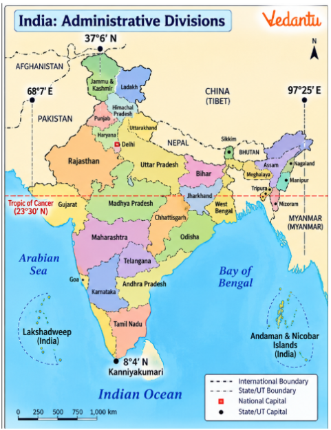
(a) Which region lies towards the northern end of mainland India?
Answer: The northern mainland extends through the Himalayan region, including Kashmir.
(b) Which state lies near the easternmost mainland extent?
Answer: Arunachal Pradesh lies near India's easternmost mainland extent.
(c) Which place marks the southern end of mainland India?
Answer: Kanniyakumari in Tamil Nadu marks the southern end of mainland India.
(d) Name India's two major island groups and the seas in which they lie.
Answer: The Andaman and Nicobar Islands lie in the Bay of Bengal, while Lakshadweep lies in the Arabian Sea.
(e) Which important latitude crosses the central part of India?
Answer: The Tropic of Cancer (approximately 23°30′ N) crosses India.
Q13. How does India's location across tropical and subtropical latitudes contribute to its physical diversity?
Answer: India's latitudinal spread places different regions under different geographical conditions.
Tropical Region: Southern India lies within the tropics and generally experiences warmer conditions.
Subtropical Region: Northern India extends into the subtropical or warm temperate zone.
Temperature Variation: Differences in latitude influence the amount and seasonal variation of solar energy received.
Climatic Diversity: The country experiences different temperature and rainfall conditions across regions.
Natural Vegetation: Climate variations support different vegetation types.
Physical Environment: Latitude is one factor influencing India's regional differences in climate, soils, and vegetation, along with relief and other factors.
Conclusion: India's position across tropical and subtropical latitudes contributes to its geographical diversity rather than producing uniform conditions throughout the country.
Q14. How do the Himalayas and adjoining mountain ranges influence India's geographical identity and connections with neighbouring regions?
Answer: The mountain ranges surrounding northern India have influenced travel, communication and regional identity.
1. Northern Boundary: The Himalayas form a major geographical barrier to the north.
2. Northwestern Mountains: The Hindu Kush and Sulaiman ranges form important barriers towards the northwest.
3. Northeastern Mountains: The Purvachal hills mark the northeastern mountainous region.
4. Restricted Movement: High mountains and difficult terrain made journeys between the subcontinent and neighbouring regions challenging in earlier times.
5. Mountain Passes: Passes such as Khyber, Bolan, Shipkila, Nathu La and Bomdila provided routes through the mountains.
6. Regional Identity: These mountain systems contributed to the development of a distinct geographical identity for the Indian subcontinent.
Conclusion: The mountains created important physical barriers, but passes allowed communication and movement between regions.
Class 11 Geography Chapter 1 Long Answer Questions
Q15. Explain India's latitudinal and longitudinal extent. How do these coordinates influence its climate, local time and geographical diversity?
Answer: India's geographical extent matters because it influences climatic differences, time variations, and the physical characteristics of different regions.
1. Latitudinal Extent of Mainland India
The mainland extends from approximately 8°4′ N to 37°6′ N latitude.
The southern limit of India's territory, including its islands, extends to approximately 6°45′ N.
2. Longitudinal Extent
India extends from approximately 68°7′ E to 97°25′ E longitude.
The country therefore covers nearly 30° from west to east.
3. North–South Distance
The distance between the northern and southern extremities is approximately 3,214 km.
4. East–West Distance
India's east–west distance is approximately 2,933 km.
5. Influence on Climate
Southern India lies within tropical latitudes, while the northern part extends into the subtropical or warm temperate zone.
This difference contributes to variations in temperatures and seasonal conditions.
6. Influence on Natural Vegetation
Regional climatic differences help explain why different types of natural vegetation occur across India.
7. Longitudinal Influence on Time
The easternmost and westernmost parts of India experience a local time difference of nearly two hours.
This results from Earth's rotation and the difference in longitude.
8. Need for a Standard Meridian
Without standard time, different regions would use different local times, making it difficult to coordinate activities.
9. Indian Standard Time
India uses 82°30′ E longitude as the standard meridian.
IST is 5 hours and 30 minutes ahead of GMT.
10. Physical Diversity
India's large geographical extent includes mountains, plains, plateaus, deserts, forests, rivers and coastal regions.
Latitude, relief and other geographical factors together influence this diversity.
Conclusion: India's position and extent explain important regional differences while showing why a common standard time is useful for the country.
Q16. Explain why India follows one standard time despite having a local time difference of nearly two hours between its eastern and western regions.
Answer: India follows a common standard time to ensure consistent timekeeping across a country that stretches widely from east to west.
1. India's Longitudinal Extent
India stretches across nearly 30° of longitude.
The easternmost parts are located much farther east than the westernmost parts.
2. Earth's Rotation
Earth rotates through approximately 360° in 24 hours.
Therefore:
$$360^{\circ} \div 24 = 15^{\circ}\ \text{per hour}$$
This means Earth rotates through 1° in approximately four minutes.
3. Calculating India's Approximate Time Difference
For nearly 30° of longitude:
30 × 4 = 120 minutes
Therefore, the approximate local solar-time difference is two hours.
4. Earlier Sunrise in Eastern India
The Sun rises earlier in northeastern regions such as Assam, Nagaland and Manipur than in western Rajasthan.
5. One Standard Meridian
To avoid different clock times, India adopted 82°30′ E as its standard meridian.
6. Relationship with Greenwich Mean Time
$$82.5^{\circ} \div 15^{\circ} = 5.5\,\text{hours}$$
Thus, Indian Standard Time is 5 hours and 30 minutes ahead of GMT.
7. Same Clock Time Across India
Dibrugarh, Imphal, Jaisalmer, Bhopal and Chennai all follow IST.
Their clocks show the same official time even though local sunrise and sunset timings differ.
8. Importance of a Common Time
One time standard makes it easier to coordinate railway schedules, communication, school timings and administrative activities.
9. Countries with Multiple Time Zones
The chapter explains that some countries with very large east–west extents use more than one standard time zone.
It gives the United States as an example.
10. Possibility of More Than One Time Zone
India's eastern regions experience sunrise significantly earlier than its western regions.
This has led to discussion about whether multiple standard times could better match regional daylight hours. However, India follows one official standard time.
Conclusion: A single standard time keeps official timekeeping uniform, while the nearly two-hour difference in local solar time remains a natural result of India's longitudinal extent.
Q17. How does India's size contribute to its physical diversity? Explain with examples of mountains, rivers, deserts, forests and coastal regions.
Answer: India is one of the world's largest countries, and its geographical size contributes to major variations in landscapes and natural resources.
1. Total Geographical Area
India covers approximately 3.28 million square kilometres.
India is the seventh-largest country in the world
2. Share of the World's Land Area
India accounts for approximately 2.4% of the world's land surface.
3. Mountain Landscapes
The Himalayan mountain system forms an extensive mountainous region in the north.
These mountains differ significantly from the plains and coastal areas.
4. Large River Systems
Major rivers mentioned in the chapter include the Ganga, Brahmaputra, Mahanadi, Godavari, Krishna and Kaveri.
They flow through different physical environments and support varied landscapes.
5. Desert Region
Extensive sandy landscapes characterise the Marusthali region in western India.
It contrasts with the wetter and forested regions elsewhere.
6. Forested Hills
Northeastern India and parts of southern India contain green, forested hills.
These areas differ from the desert and plains in vegetation and relief.
7. Peninsular Landmass
The peninsular region extends southward into the Indian Ocean.
It creates long coastlines along the Arabian Sea and Bay of Bengal.
8. Island Groups
The Andaman and Nicobar Islands and Lakshadweep add further geographical diversity.
9. Variety of Natural Resources
Mountains, rivers, forests, plains and coastal areas provide different natural resources and conditions for human activities.
10. Interaction of Geographical Factors
India's physical diversity results from its large area, latitudinal spread, geological characteristics and relief.
Comparison of Major Physical Features
Conclusion: India's size accommodates several contrasting physical environments, making it a geographically diverse country.
Q18. Study Figure 1.2 - Location of India in the Eastern World. Explain how India's maritime position connects it with neighbouring countries and other parts of the world.
Answer: India's location in south-central Asia gives it an important position in the Indian Ocean region.
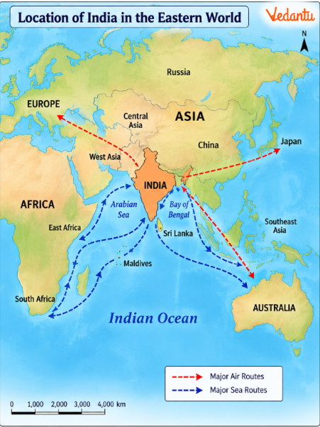
The source map shows India in relation to Asia, Africa and Australia, with air and sea routes connecting important regions.
1. South-Central Asian Location
India occupies a south-central position within Asia.
This places the country between important regions of western, central, eastern and southeastern Asia.
2. Peninsular Extension
Peninsular India extends into the Indian Ocean.
Its location brings it close to major maritime routes.
3. Arabian Sea
The Arabian Sea lies to the west of India.
It provides sea connections with Western Asia and the eastern coast of Africa.
4. Bay of Bengal
The Bay of Bengal lies to the east of India.
It provides maritime connections with Southeast Asia.
5. Indian Ocean
The Indian Ocean links India with regions beyond its immediate neighbours.
It forms an important geographical setting for trade and international movement.
6. Connections Through Sea Routes
Figure 1.2 shows routes linking India with other regions of the Eastern World.
These illustrate the advantages of India's maritime location.
7. Connections Through Air Routes
The map also shows air links, indicating how modern transport can connect India with distant countries.
8. Island Neighbours
Sri Lanka and the Maldives are India's neighbouring island countries in the Indian Ocean region.
9. India and Sri Lanka
The Palk Strait and Gulf of Mannar separate India from Sri Lanka.
10. Importance of the Location
India's maritime position supports international interaction, transport and communication.
Map-Based Questions
(a) Which two major water bodies lie on either side of Peninsular India?
Answer: The Arabian Sea lies to the west, and the Bay of Bengal lies to the east.
(b) Which ocean lies south of Peninsular India?
Answer: The Indian Ocean.
(c) Which neighbouring island countries are shown near India?
Answer: Sri Lanka and the Maldives.
(d) What do the air and sea routes in Figure 1.2 represent?
Answer: They show India's connections with surrounding regions and the wider world through transport routes.
Conclusion: India has an advantageous geographical position because its peninsular landmass extends into the Indian Ocean, making interaction with nearby and distant regions possible through sea and air routes.
Q19. Explain the significance of India's coastline and island groups. How do they influence its geographical identity and relations with other countries?
Answer: India's coastline and islands are key parts of its geography. They connect the country with the Indian Ocean and contribute to its physical diversity.
1. Length of the Mainland Coastline
The chapter gives the mainland coastline as approximately 6,100 km.
2. Total Coastline Including Islands
The chapter gives approximately 7,517 km when the island groups are included.
These figures are reproduced as presented in the prescribed textbook.
3. Peninsular India
Peninsular India extends into the Indian Ocean.
Its coasts face the Arabian Sea and the Bay of Bengal.
4. Andaman and Nicobar Islands
These islands lie in the Bay of Bengal.
They extend India's geographical presence southeastward.
5. Lakshadweep
Lakshadweep lies in the Arabian Sea, to the west of the Indian mainland.
6. Territorial Waters
India's territorial waters extend up to 12 nautical miles from its coastal baselines.
7. Maritime Connections
India's coast provides access to routes connecting different parts of the Indian Ocean region.
8. Trade and Transport
Coastal locations support maritime transport and the movement of goods and people.
9. Relations with Neighbouring Countries
India's coastal position connects it geographically to island countries such as Sri Lanka and the Maldives.
10. Physical Diversity
The mainland coast and offshore islands contribute to India's variety of landforms and natural environments.
11. Sea Boundaries and Land Boundaries
India has both land connections with mainland neighbours and maritime connections with island countries and other regions.
12. Geographical Importance
The coastline expands India's geographical interactions beyond its land borders.
Comparison of India's Maritime Features
Conclusion: India's extensive coastline and island territories strengthen its geographical links with surrounding countries and provide access to the wider Indian Ocean.
Q20. Describe India's location in relation to its neighbouring countries. Why have mountains, passes and seas been important in shaping regional interaction?
Answer: India's position in South Asia places it among several neighbouring countries. Mountains and seas have influenced movement, communication and regional relationships over time.
1. Location Within Asia: India lies in the south-central part of the continent of Asia. Its peninsular region extends into the Indian Ocean.
2. Northwestern Neighbourhood: Pakistan lies to India's northwest and west. Afghanistan is also located in the broader northwestern geographical region shown in the chapter's maps.
3. Northern Neighbourhood: China, Nepal and Bhutan are located to the north or along India's Himalayan region.
4. Eastern Neighbourhood: Bangladesh and Myanmar lie towards India's eastern side.
5. Island Neighbours: Sri Lanka and Maldives are neighbouring island countries in the Indian Ocean.
6. Himalayan Mountains: The Himalayas form a major physical barrier along India's northern region.
7. Northwestern Mountain Ranges: The Hindu Kush and Sulaiman ranges are important parts of the broader northwestern mountain system.
8. Northeastern Mountains: The Purvachal hills form part of the mountainous landscape towards the northeast.
9. Importance of Passes: Mountain passes make it possible to move to high mountain regions. The chapter mentions Khyber, Bolan, Shipki La, Nathu La, and Bomdila.
10. Historical Barriers: In earlier times, mountains and difficult terrain restricted travel and interaction between regions.
11. Modern Connections: Modern roads, air transport and communication networks have improved connections across difficult terrain.
12. Maritime Connections: The Arabian Sea, Bay of Bengal and Indian Ocean offer alternative routes for interaction.
13. Geographical Unity: The mountain barriers to the north and the Indian Ocean to the south contributed to the development of a distinct geographical identity for the Indian subcontinent.
14. International Interaction: India's location supports contact with neighbouring countries through land, sea and air routes.
Conclusion: India's relations with neighbouring regions have been shaped by both barriers and connecting routes. Mountains influenced historical movement, while passes, seas and modern transport networks continue to support regional interaction.
Why Practise Class 11 Geography Chapter 1 Important Questions with Vedantu?
Vedantu's India - Location Important Questions help students understand how geographical coordinates explain time differences, climate variations and India's position in the world. The solved questions also include map interpretation, distance calculations, the standard meridian and India's maritime connections.
How to Prepare Class 11 Geography Chapter 1 Important Questions with Vedantu?
Learn the coordinates: Practise writing India's latitudinal and longitudinal extent accurately.
Understand time calculations: Remember that 1° of longitude represents approximately four minutes.
Use the chapter maps: Identify mainland extremities, the Tropic of Cancer, island groups and neighbouring countries.
Compare distances: Explain why the north–south and east–west distances differ despite similar angular extents.
Connect location with physical features: Use examples such as the Himalayas, Marusthali, Arabian Sea and Bay of Bengal.
Important Study Material Links for Class 11 Geography Chapter 1
CBSE Class 11 Geography Other Books Important Questions and Study Resources
Chapter-Wise Important Questions for Class 11 Geography - India: Physical Environment
After practising Chapter 1 India - Location Important Questions, students can continue with other chapters of India: Physical Environment to understand the country's landforms, river systems, climate, vegetation and natural hazards.
Important Study Materials for Class 11 Geography
FAQs on Important Questions and Answers for Class 11 Geography Chapter 1 - India - Location (India: Physical Environment) | 2026-27
1. What are the main topics covered in Class 11 Geography Chapter 1: India – Location?
Chapter 1 covers India's latitudinal and longitudinal extent, geographical size, Indian Standard Time, coastline, island groups, physical diversity, the Indian subcontinent and neighbouring countries. It also includes two maps that explain India's administrative divisions and its position in the Eastern World.
2. What are the latitudinal and longitudinal extents of India as covered in Class 11 Geography?
Mainland India extends approximately from 8°4′ N to 37°6′ N latitude and 68°7′ E to 97°25′ E longitude. India's territory extends farther south through the Nicobar Islands, reaching approximately 6°45′ N latitude.
3. Why is India's north–south distance greater than its east–west distance?
The north–south distance is approximately 3,214 km, while the east–west distance is 2,933 km. This difference occurs because the distance between two longitudes decreases towards the poles, while the distance represented by one degree of latitude remains nearly constant.
4. Why is 82°30′ E selected as the Standard Meridian of India?
India uses 82°30′ E as its standard meridian to maintain a common official time across the country. It is also a multiple of 7°30′, following a widely used convention for selecting standard meridians. IST is 5 hours and 30 minutes ahead of GMT.
5. Why does the Sun rise earlier in northeastern India than in Rajasthan?
Earth rotates from west to east. Northeastern India lies farther east than Rajasthan and therefore experiences sunrise earlier. However, both regions follow Indian Standard Time, so their official clocks use the same time.
6. How does India's latitudinal location influence its climate and natural vegetation?
Southern India lies within tropical latitudes, while northern India extends into subtropical latitudes. This geographical spread contributes to variations in temperature, climate and vegetation. Relief, rainfall and other geographical factors also influence these differences.
7. What is the difference between mainland India and India's total geographical extent?
Mainland India is the continuous landmass extending from the Himalayan region to Kanniyakumari. India's total geographical extent also includes island territories, such as Andaman and Nicobar and Lakshadweep, which extend its boundaries into the surrounding seas.
8. Why is India's long coastline important for its geographical location?
India's coastline provides access to the Arabian Sea, the Bay of Bengal, and the Indian Ocean. This supports maritime transport, international trade and connections with neighbouring island countries and other regions.
9. Which maps are important for Class 11 Geography Chapter 1?
Figure 1.1, India: Administrative Divisions, helps students identify states, island groups, geographical extremities and important latitudes. Figure 1.2, Location of India in the Eastern World, explains India's location relative to other countries and shows important sea and air connections.
10. How should students practise Class 11 Geography India Physical Environment Chapter 1 Important Questions?
Students can begin with MCQs to revise coordinates, the standard meridian and neighbouring countries. Next, they should practise explaining time differences, latitude–longitude distances, and physical diversity. Finally, map-based and long-answer questions can help strengthen geographical reasoning and answer-writing skills.