


Class 11 Geography Chapter 5 Natural Vegetation Important Questions with Answers PDF
Practise 28 important questions covering India’s natural vegetation, forest classification, regional plant adaptations, social forestry, wildlife conservation and biosphere reserves. This Class 11 Geography Chapter 5 Natural Vegetation Important Questions and Answers set includes six MCQs, five very short answers, eight short answers, and nine long answers, plus map- and image-based exercises.
Class 11 Geography Chapter 5 Natural Vegetation Important Questions MCQ with Answers
Q1. A rosewood tree growing naturally in a forest and a rosewood tree planted in a garden may belong to the same species. What makes the forest tree part of natural vegetation?
(a) It grows only in cold climates.
(b) It develops under natural conditions without prolonged human supervision.
(c) It has a greater height than the planted tree.
(d) It is used only for timber.
Answer: (b) It develops under natural conditions without prolonged human supervision.
Explanation: Natural vegetation consists of plant communities that have remained largely undisturbed for a long time, allowing species to adjust to local climate and soil conditions.
Q2. Which combination of climate and vegetation matches the given climatic conditions?
(a) Rainfall below 50 cm — Tropical evergreen forests
(b) Rainfall above 200 cm and temperature above 22°C — Tropical evergreen forests
(c) Rainfall 70–100 cm — Mangrove forests only
(d) Rainfall above 200 cm — Tropical thorn forests
Answer: (b) Rainfall above 200 cm and temperature above 22°C — Tropical evergreen forests.
Explanation: Tropical evergreen forests develop in warm, humid regions that receive more than 200 cm of annual rainfall and have mean annual temperatures above 22°C.
Q3. Why are tropical deciduous forests also called monsoon forests?
(a) They grow only in the Himalayas.
(b) Their leaf-shedding cycle is closely associated with seasonal changes in rainfall.
(c) They remain completely submerged throughout the year.
(d) They grow only where annual rainfall exceeds 400 cm.
Answer: (b) Their leaf-shedding cycle is closely associated with seasonal changes in rainfall.
Explanation: Tropical deciduous forests occur mainly in regions receiving 70–200 cm of rainfall. Many trees shed their leaves during the dry season to reduce moisture loss.
Q4. A vegetation survey finds babool, ber, khejri and wild date palm in a region receiving less than 50 cm of annual rainfall. Which forest type is most likely present?
(a) Tropical evergreen forest
(b) Moist deciduous forest
(c) Tropical thorn forest
(d) Wet temperate forest
Answer: (c) Tropical thorn forest.
Explanation: Thorn forests grow in low-rainfall, semi-arid regions. Their vegetation includes grasses, shrubs and drought-adapted trees such as babool, ber and khejri.
Q5. Which pair correctly matches a biosphere reserve with its state or region in Table 5.1?
(a) Nanda Devi — Uttarakhand
(b) Nokrek — Rajasthan
(c) Gulf of Mannar — Assam
(d) Nilgiri — Punjab
Answer: (a) Nanda Devi — Uttarakhand.
Explanation: Nanda Devi Biosphere Reserve is in Uttarakhand. The Nilgiri Biosphere Reserve extends across Tamil Nadu, Kerala and Karnataka, while Nokrek is in Meghalaya.
Q6. Which of the following correctly identifies the main purpose of Project Tiger?
(a) To relocate all tigers to zoological parks
(b) To conserve viable tiger populations and their natural habitats
(c) To replace natural forests with plantations
(d) To encourage commercial hunting
Answer: (b) To conserve viable tiger populations and their natural habitats.
Explanation: Project Tiger was launched in 1973 to protect tigers and conserve biologically important habitats. It aims to maintain viable tiger populations in the wild.
Class 11 Geography Chapter 5 Very Short Answer Questions
Q7. What is natural vegetation?
Answer: Natural vegetation is a plant community that remains undisturbed for a long time, allowing its species to adapt to local climate and soil conditions without continued human supervision.
Q8. Name the five major forest groups covered in Chapter 5.
Answer: Tropical evergreen and semi-evergreen forests, tropical deciduous forests, tropical thorn forests, montane forests, and littoral and swamp forests.
Q9. Why do many trees in tropical deciduous forests shed their leaves during the dry season?
Answer: They shed leaves to reduce water loss when moisture becomes limited. This helps the trees survive the dry season until rainfall returns.
Q10. What are Shola forests, and where are they found?
Answer: Sholas are temperate forests found in the higher parts of southern mountains, particularly the Nilgiri, Anaimalai and Palani hills.
Q11. What is social forestry?
Answer: Social forestry refers to managing and protecting forests and planting trees on barren or other suitable land to support environmental protection, social welfare, and rural development.
Class 11 Geography Chapter 5 Short Answer Questions
Q12. Why do tropical evergreen forests remain green throughout the year? How are they different from semi-evergreen forests?
Answer: Tropical evergreen forests grow in warm, humid regions with heavy rainfall. They remain green because trees do not shed their leaves at the same time.
Rainfall: Evergreen forests receive more than 200 cm annually.
Temperature: Mean annual temperatures generally exceed 22°C.
Layers: Shrubs, creepers, shorter trees and tall trees form distinct layers.
Height: Some trees reach 60 metres or more.
Leaf shedding: Not all trees shed leaves simultaneously.
Semi-evergreen: Found in relatively less rainy areas, with a mixture of evergreen and moist deciduous trees.
Conclusion: Semi-evergreen forests contain a greater mixture of trees with different leaf-shedding habits.
Q13. How do moist deciduous and dry deciduous forests differ in rainfall, distribution and tree species?
Answer: Tropical deciduous forests are the most widespread in India. They are divided according to water availability.
Conclusion: Moist deciduous forests receive more rain; dry deciduous forests transition towards thorn vegetation at drier margins.
Q14. Study Figure 5.2 – Natural Vegetation. Identify India’s major vegetation zones using the map.
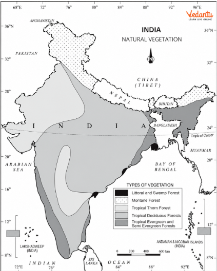
Figure 5.2 – Natural Vegetation (textbook page 43).
(a) Which type is widespread across central and Peninsular India?
Answer: Tropical deciduous forests.
(b) What grows along the western slopes of the Western Ghats?
Answer: Tropical evergreen and semi-evergreen forests.
(c) Which vegetation appears in dry western Rajasthan?
Answer: Tropical thorn forests.
(d) What dominates the higher Himalayan region?
Answer: Montane forests.
(e) What is associated with the Sundarbans and coastal deltas?
Answer: Littoral and swamp vegetation, including mangroves.
(f) What does the map reveal about climate and vegetation?
Answer: Humid regions support dense forests, dry areas support thorn vegetation, and high mountains support vegetation adapted to altitude.
Q15. Study Figure 5.4 – Tropical Thorn Forests. What features help these plants survive in dry regions?
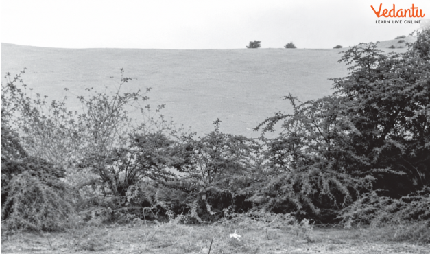
Figure 5.4 – Tropical Thorn Forests (textbook page 44).
Answer: Tropical thorn vegetation grows in areas receiving less than 50 cm of rainfall.
Low rainfall produces relatively sparse vegetation.
Trees and shrubs usually grow widely spaced.
Many plants remain leafless for much of the year.
Scrub vegetation and drought-adapted bushes are common.
Typical species include babool, ber, wild date palm, khair, neem and khejri.
Tussocky grasses may grow to about 2 metres.
Conclusion: Thorn forests show how plants adjust to low rainfall and water scarcity.
Q16. Why does natural vegetation change with increasing altitude in the Himalayas?
Answer: Temperature generally decreases with increasing altitude, creating a succession of vegetation zones.
Conclusion: Temperature and moisture vary with altitude, shaping different vegetation belts.
Q17. What makes wetlands important for birds and biodiversity? Give suitable examples.
Answer: Wetlands provide habitats for waterbirds, plants and other wildlife. They include freshwater, saline, coastal and tidal environments.
Wetlands supply water and suitable habitat for dependent species.
They support plants adapted to different water and salinity conditions.
The chapter identifies Chilika Lake in Odisha and Keoladeo National Park in Bharatpur.
The chapter discusses these sites in the context of the Ramsar Convention on internationally important wetlands.
Conclusion: Wetland protection preserves habitats and biodiversity.
Q18. How did commercial forest exploitation during British rule change India’s forest composition?
Answer: The chapter explains that colonial forest management increasingly prioritised commercial value.
Colonial authorities exploited forests for economically valuable timber.
In parts of Garhwal and Kumaon, railway needs replaced oak forests with chir pine.
Forest land was cleared for tea, rubber and coffee plantations.
Timber was widely used in construction.
Commercial management changed the composition of some forest areas and increased pressure on natural vegetation.
Conclusion: Commercial priorities altered forest structure and reduced emphasis on ecological protection.
Q19. Distinguish between urban forestry, agroforestry, community forestry and farm forestry.
Answer: These tree-growing practices serve different locations and community needs.
Agroforestry and community forestry belong to rural forestry. Conclusion: These practices increase tree cover while supporting environmental and livelihood needs.
Class 11 Geography Chapter 5 Long Answer Questions
Q20. Describe India’s five major forest types. How do rainfall, temperature and altitude influence their distribution?
Answer: Different combinations of rainfall, temperature, soil and relief create India’s major vegetation regions.
Tropical evergreen and semi-evergreen: Warm, humid forests of the Western Ghats, northeastern hills, and islands; rainfall generally above 200 cm; rosewood and ebony.
Tropical deciduous: The most widespread type, receiving about 70–200 cm rain; includes moist and dry types with teak, sal and tendu.
Tropical thorn: Semi-arid areas with less than 50 cm of rain; babool, ber, khair and khejri.
Montane: Himalayan and high southern mountain regions; vegetation shifts with altitude from deciduous to conifers and alpine plants.
Littoral and swamp: Wetlands, estuaries and deltas; includes salt-tolerant mangroves.
Conclusion: Forest distribution reflects the combined role of climate, topography and soil.
Q21. Trace the changes in natural vegetation from the Himalayan foothills to the highest mountains. Explain the important tree species and human activities associated with each zone.
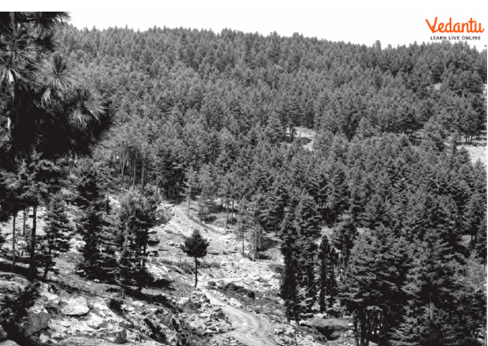
Figure 5.5 – Montane Forests (textbook page 45).
Answer: Himalayan vegetation changes from lower deciduous forests to temperate conifers, alpine pastures and tundra at the highest elevations.
Foothills: Deciduous trees grow where conditions are warmer.
1,000–2,000 m: Wet temperate forests develop.
Broadleaf evergreens: Oak and chestnut occur in suitable higher hills.
1,500–1,750 m: Chir pine becomes important.
Western Himalayas: Deodar is valued for its durable timber; chinar and walnut support Kashmir handicrafts.
2,225–3,048 m: Blue pine and spruce are found.
3,000–4,000 m: Silver fir, juniper, birch, pine, rhododendron and alpine pastures occur.
Pastoral activities: Gujjars, Bakarwals, Bhotiyas and Gaddis use mountain pastures for transhumance.
Highest elevations: Mosses and lichens grow in tundra conditions.
Slope variation: Southern Himalayan slopes generally have thicker vegetation because they receive more precipitation.
Conclusion: Different altitude belts sustain different vegetation and human activities.
Q22. Why are mangrove forests found in coastal deltas and tidal regions? Explain their characteristics, distribution and conservation needs.
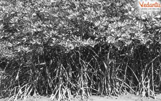
Figure 5.6 – Mangrove Forests (textbook page 46).
Answer: Mangrove forests develop in coastal salt marshes, tidal creeks, mudflats and estuaries.
Mangrove species tolerate salty water and tidal influence.
They inhabit complex, waterlogged coastal wetland environments.
Their forests shelter birds and other wetland organisms.
Major regions include the Sundarbans, the Andaman and Nicobar Islands, and the Mahanadi, Godavari and Krishna deltas.
The textbook records a mangrove area of 4,992 sq. km (textbook figure, not a current verified total).
Encroachment and habitat disturbance make conservation necessary.
Conclusion: Mangroves are specialised coastal forests important for wetland biodiversity.
Q23. Explain the objectives of India’s Forest Conservation Policy. Why is community participation important?
Answer: The chapter discusses the Forest Policy of 1952, revised in 1988, with an emphasis on sustainable forest management.
Aim to bring 33% of the geographical area under forest cover.
Maintain environmental stability and restore disturbed ecosystems.
Protect biodiversity and genetic resources.
Reduce soil erosion, desert expansion and certain flood and drought impacts.
Encourage social forestry and afforestation on degraded land.
Support the availability of timber, fuel, fodder and food to forest-dependent people.
Encourage wood substitutes and reduce pressure on existing forests.
Involve women and local communities in planting and forest protection.
Value tribal communities’ traditional knowledge and participation.
Conclusion: Forest conservation is more effective when environmental goals and community needs are considered together.
Q24. Explain the three types of social forestry described in the chapter. How can these practices benefit farmers and local communities?
Answer: The National Commission on Agriculture (1976) classified social forestry into urban, rural and farm forestry.
Urban forestry: Raising trees in parks, green belts, streets and public/private city land.
Rural forestry: Includes agroforestry and community forestry.
Agroforestry: Trees and crops on the same land can produce food, fodder, fuel, timber and fruit.
Community forestry: Trees on village commons, school land, roadsides, railway strips and canal banks provide shared benefits.
Farm forestry: Farmers grow trees on farmland for commercial or household use, including field margins and land near houses.
The chapter mentions forest departments distributing seedlings to encourage tree planting.
Conclusion: Social forestry encourages tree cover and community participation beyond existing natural forests.
Q25. Why is wildlife declining in some regions of India? Explain the threats to wildlife and the need for habitat conservation.
Answer: Human activity has disturbed many wildlife habitats, reducing some species' populations.
Rapid exploitation of forest resources.
Land clearance for agriculture and settlements.
Roads, reservoirs, mining and infrastructure development.
Collection of fuelwood, fodder and small timber.
Heavy grazing by domestic livestock.
Historical hunting and present-day poaching.
Forest fires and habitat loss.
Reduced biodiversity as ecological conditions change.
National parks, wildlife sanctuaries and public awareness can help protect species and habitat.
Conclusion: Wildlife protection requires conservation of the natural habitats on which species depend.
Q26. Explain the major wildlife conservation measures covered in the chapter, with special reference to the Wildlife Protection Act, Project Tiger and Project Elephant.
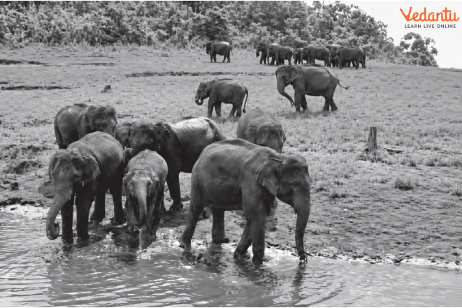
Figure 5.7 – Elephants in Their Natural Habitat (textbook page 48).
Answer: India uses legal protection, protected areas and species-specific programmes to conserve wildlife.
Wildlife Protection Act, 1972: Principal legal framework for listed species and protected areas.
The 1991 amendment, as described in the chapter, strengthened provisions and punishments.
Launched in 1973, Project Tiger aims to maintain viable wild tiger populations and protect natural habitats.
According to the textbook, Project Tiger initially covered nine tiger reserves and 16,339 sq. km.
The supplied edition reports 58 tiger reserves and a tiger estimate of 3,682 in 2023 (historical textbook figures).
Project Elephant, launched in 1992, supports conservation of free-ranging elephants in their habitat.
Other projects mentioned include Crocodile Breeding, Project Hangul and Himalayan musk deer conservation.
Conclusion: Long-term wildlife protection requires laws, protected habitats, specialised programmes and public participation.
Q27. Study Figure 5.8 and Table 5.1. Identify important biosphere reserves, their locations and designation years.
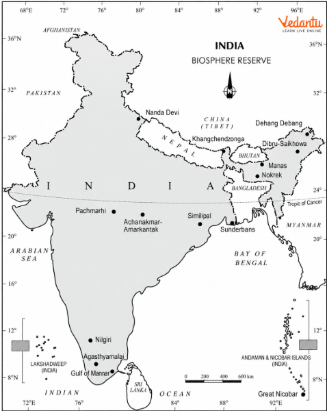
Figure 5.8 – India: Biosphere Reserves (textbook page 49).
Answer: Biosphere reserves protect representative ecosystems while supporting study and appropriate development. Table 5.1 lists 18 reserves.
(a) Which reserve is in Uttarakhand?
Answer: Nanda Devi.
(b) Which reserve covers Tamil Nadu, Kerala and Karnataka?
Answer: Nilgiri.
(c) Which coastal reserve is in Tamil Nadu?
Answer: Gulf of Mannar.
(d) Which reserve is in Meghalaya?
Answer: Nokrek.
(e) Which reserve is in West Bengal?
Answer: Sundarbans.
(f) Which reserve is on the Andaman and Nicobar Islands?
Answer: Great Nicobar.
(g) Which reserve covers Madhya Pradesh and Chhattisgarh?
Answer: Achanakmar-Amarkantak.
(h) Which is the earliest designated reserve in the table?
Answer: Nilgiri, 1986.
Q28. Study Figure 5.9 - Objectives of a Biosphere Reserve. Explain how conservation, development and research work together.
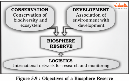
Figure 5.9 – Objectives of a Biosphere Reserve (textbook page 50).
Answer: A biosphere reserve is a representative ecosystem associated with UNESCO’s Man and the Biosphere Programme. Figure 5.9 identifies three complementary functions.
Conservation: Protecting biodiversity, species and ecosystems.
Development: Promoting links between environmental protection and appropriate development.
Logistic support: Research, environmental monitoring and information exchange.
Monitoring helps researchers study changes in habitats and ecosystems.
International cooperation supports long-term learning across reserves.
The prescribed textbook edition lists 18 Indian biosphere reserves and states that, at its reference date, 12 were recognised in UNESCO’s network.
Conclusion: Biosphere reserves conserve ecosystems while also supporting responsible development and scientific understanding.
Why Practise Class 11 Geography Chapter 5 Important Questions with Vedantu?
Vedantu’s Natural Vegetation Important Questions help students revise India’s forest types, vegetation distribution, wildlife and conservation efforts through detailed answers and map practice.
How to Prepare Class 11 Geography Chapter 5 Important Questions?
Compare forest types: Learn rainfall requirements, regions and key species.
Study vegetation patterns: Link altitude, rainfall and soil to vegetation.
Practise map-based questions: Use Figures 5.2 and 5.8.
Revise conservation: Understand social forestry, wildlife laws and policy.
Use examples: Remember Sundarbans, Nilgiri, Nanda Devi and other textbook locations.
Important Study Material Links for Class 11 Geography Chapter 5
Students can use these chapter-specific resources to revise forest characteristics, conservation methods, and key examples.
CBSE Class 11 Geography Other Books Important Questions and Study Resources
Chapter-Wise Important Questions for Class 11 Geography – India: Physical Environment
Students can also explore questions from other chapters of India: Physical Environment to connect India’s location, landforms, rivers, climate and natural vegetation.
Important Study Materials for Class 11 Geography
FAQs on Important Questions and Answers for Class 11 Geography Chapter 5 - Natural Vegetation (India: Physical Environment) | 2026-27
1. Which topics are most important in Class 11 Geography Chapter 5: Natural Vegetation?
Focus on India's five forest types, their rainfall requirements, important tree species and regional distribution. Also revise Himalayan vegetation, mangroves, social forestry, wildlife conservation and biosphere reserves. Figures 5.2 and 5.8 are particularly useful for map-based practice.
2. What is the difference between natural vegetation and planted vegetation?
Natural vegetation develops over time without continued human supervision and adapts to local climate and soil. Planted vegetation is grown or maintained by people, such as in gardens, orchards and plantations. The same species can occur in both.
3. Why are tropical deciduous forests more widespread in India than evergreen forests?
Tropical deciduous forests grow in regions receiving about 70–200 cm of annual rainfall and cover large areas of India. Evergreen forests require wetter conditions, generally more than 200 cm, and are concentrated in humid regions.
4. Which forest types and tree species should I remember for Class 11 Geography Chapter 5 Natural Vegetation question answers?
Learn rosewood and ebony for evergreen forests; teak and sal for deciduous forests; babool and khejri for thorn forests; oak, pine and deodar for montane forests; and salt-tolerant mangroves for coastal wetlands.
5. Why do forests change from deciduous trees to pine and alpine vegetation as we move higher in the Himalayas?
Temperature generally decreases with altitude. Lower slopes support deciduous vegetation; higher elevations have temperate forests and conifers; and the highest zones support alpine pastures, mosses, and lichens.
6. Why are the Sundarbans important in India’s natural vegetation chapter?
The Sundarbans contain a major mangrove ecosystem. These forests grow in tidal, saline, and waterlogged conditions and provide important habitat for wildlife. The chapter also lists the Sundarbans as a biosphere reserve.
7. What is the difference between forest area and forest cover?
Forest area generally refers to land officially recorded as forest, whether or not it is completely tree-covered. Forest cover refers to land with actual tree cover under the relevant assessment criteria, including qualifying areas outside recorded forests. chapter includes this distinction as an exercise question.
8. How is social forestry different from farm forestry?
Social forestry is the wider effort to plant and manage trees for community and environmental benefits. Farm forestry specifically means farmers growing trees on their own land for commercial or non-commercial purposes.
9. What is the difference between Project Tiger and Project Elephant?
Project Tiger began in 1973 and focuses on conserving viable tiger populations and their habitats. Project Elephant began in 1992 and supports the protection of free-ranging wild elephants and their natural habitats.
10. Which biosphere reserves are important for Class 11 Geography India Physical Environment Chapter 5 Important Questions?
Focus on Nilgiri, Nanda Devi, Nokrek, Sundarban, Gulf of Mannar, Great Nicobar, Manas and Similipal. Learn their states from Figure 5.8 and designation years from Table 5.1.
11. Are Class 11 Geography Chapter 5 Natural Vegetation Important Questions MCQs useful for exams?
Yes. MCQs test forest types, rainfall ranges, trees, conservation projects and reserve locations. Also practise explanation-based comparisons and map-based questions that require deeper understanding.
12. How can I use Class 11 Geography Chapter 5 Natural Vegetation Important Questions PDF for revision?
Practise the MCQs and very short answers first, then compare forest types and revise conservation questions and maps. Check difficult answers against the chapter.