


Class 11 Geography Chapter 3 Drainage System Important Questions with Answers PDF
Practise 20 important questions from Class 11 Geography Chapter 3, Drainage System, including five MCQs, four very short answers, five short answers and six long answers. These questions focus on how drainage patterns form, the courses and tributaries of major Indian rivers, differences between Himalayan and Peninsular drainage, and the causes of floods and river-course changes. Each question includes a detailed answer to help students understand the concepts and practise writing clear exam answers.
Class 11 Geography Chapter 3 MCQs with Answers
Q1. Rivers originating from the Amarkantak range flow outward in different directions. Which drainage pattern does this represent?
(a) Dendritic drainage
(b) Trellis drainage
(c) Radial drainage
(d) Centripetal drainage
Answer: (c) Radial drainage.
Explanation: In a radial drainage pattern, rivers originate from a central highland and flow outward in different directions. Rivers originating from the Amarkantak Range are an example of radial drainage.
Q2. Which geographical features form an important water divide between the Arabian Sea and Bay of Bengal drainage systems?
(a) Shiwalik Hills, Bhabar and Tarai
(b) Delhi Ridge, Aravallis and Sahyadris
(c) Rajmahal Hills, Sundarbans and Malda Gap
(d) Ganga Plain, Brahmaputra Valley and Coromandel Coast
Answer: (b) Delhi Ridge, Aravallis and Sahyadris.
Explanation: The Delhi Ridge, Aravallis, and Sahyadris are important features separating the two drainage systems. About 77% of India's drainage area drains into the Bay of Bengal, while 23% drains into the Arabian Sea.
Q3. Why is the Kosi River known as the 'Sorrow of Bihar'?
(a) It carries no water during the monsoon.
(b) It flows entirely underground.
(c) It carries large amounts of sediment and frequently changes its course.
(d) It flows westwards into the Arabian Sea.
Answer: (c) It carries large amounts of sediment and frequently changes its course.
Explanation: The Kosi carries heavy sediment loads from its Himalayan catchment. Deposition can obstruct its channel, causing it to shift across the plains and contribute to damaging floods.
Q4. Which two major Peninsular rivers flow westwards through rift valleys?
(a) Krishna and Kaveri
(b) Mahanadi and Godavari
(c) Narmada and Tapi
(d) Son and Betwa
Answer: (c) Narmada and Tapi.
Explanation: The Narmada and Tapi flow through tectonically formed valleys towards the Arabian Sea. Most other major Peninsular rivers flow eastwards and discharge into the Bay of Bengal.
Q5. Why does the Kaveri have comparatively less seasonal variation in its flow than many other Peninsular rivers?
(a) It receives water only from melting glaciers.
(b) Its upper and lower catchments receive rainfall during different monsoon seasons.
(c) It flows entirely through an underground channel.
(d) It receives almost no rainfall in its basin.
Answer: (b) Its upper and lower catchments receive rainfall during different monsoon seasons.
Explanation: The upper Kaveri basin receives southwest monsoon rainfall, while the lower basin receives northeast monsoon rainfall. This helps maintain river flow throughout the year.
Class 11 Geography Chapter 3 Very Short Answer Questions
Q6. What is the difference between a river basin and a watershed?
Answer: A river basin is the area drained by a river and its tributaries. A watershed is the boundary separating neighbouring drainage basins. The term watershed also refers to smaller catchment areas, while river basins generally cover larger areas.
Q7. What is a perennial river? Give two examples from the Himalayan drainage system.
Answer: A perennial river carries water throughout the year because it receives a continuing supply from sources such as rainfall and melting snow. The Ganga and Brahmaputra are examples of perennial Himalayan rivers.
Q8. Name the five rivers that form the Panjnad of the Indus system.
Answer: The five rivers are Satluj, Beas, Ravi, Chenab and Jhelum. Together, they form the Panjnad river system of Punjab, which eventually joins the Indus.
Q9. What is an antecedent river? Give one example.
Answer: An antecedent river maintains its course even when the surrounding land undergoes tectonic uplift. The Satluj is an example because it maintained its course through the uplifting Himalayan region.
Class 11 Geography Chapter 3 Short Answer Questions
Q10. How do dendritic, radial, trellis and centripetal drainage patterns differ?
Answer: Drainage patterns describe how streams and rivers are arranged within a region. Their shapes depend on relief, slopes and underlying rock structures.
Explanation: Dendritic drainage resembles a branching tree, while radial drainage spreads outward from high ground. In a trellis pattern, tributaries join larger streams at nearly right angles. In a centripetal pattern, water converges into a central low-lying area.
Q11. Why are drainage basins and watersheds useful units for geographical planning?
Answer: A river basin connects different places through a common drainage network. Changes in one part of the basin can affect other areas.
Water Movement: Water from tributaries eventually enters the main river.
Flood Management: Heavy rainfall in the upper basin can increase downstream flood risk.
Soil Conservation: Erosion upstream can increase the sediment rivers carry.
Water Availability: Studying a basin helps identify regions experiencing water shortages or excess.
Pollution Control: Waste released upstream can affect water quality farther downstream.
Regional Planning: River basins provide a geographical unit for managing water and related environmental problems.
Conclusion: Basin-level planning considers the entire connected drainage system rather than treating individual locations separately.
Q12. Study Figure 3.2 – Major Rivers of India. Identify the important river systems and answer the following questions.
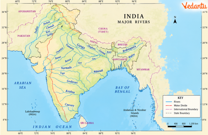
(a) Which three major Himalayan river systems are shown on the map?
Answer: The Indus, Ganga and Brahmaputra river systems.
(b) Name three major Peninsular rivers that flow into the Bay of Bengal.
Answer: Godavari, Krishna and Kaveri.
(c) Which two major Peninsular rivers flow westwards?
Answer: Narmada and Tapi.
(d) Which river drains towards the Rann of Kachchh?
Answer: The Luni.
(e) Which mountain range is an important water divide for Peninsular rivers?
Answer: The Western Ghats, also called the Sahyadris.
(f) Which major river flows through the Assam Valley?
Answer: The Brahmaputra.
Q13. How do the Bhagirathi and Alaknanda form the Ganga? Explain the important confluences mentioned.
Answer: The Ganga develops from several Himalayan streams that meet at important confluences in Uttarakhand.
Bhagirathi: It originates from the Gangotri Glacier near Gaumukh.
Alaknanda: It originates from the Satopanth Glacier above Badrinath.
Vishnuprayag: The Dhauli Ganga and Vishnu Ganga meet here, as described in the textbook.
Karnaprayag: The Pindar joins the Alaknanda.
Rudraprayag: The Mandakini joins the Alaknanda.
Devprayag: The Bhagirathi and Alaknanda meet. From this point, the river is known as the Ganga.
Haridwar: The Ganga emerges from the mountains into the Northern Plain.
Conclusion: The Ganga forms through a network of mountain streams before entering the Northern Plain at Haridwar.
Q14. Why does the Kosi frequently change its course across the plains of Bihar?
Answer: The Kosi's shifting course results from its heavy sediment load, changing river gradient and seasonal discharge.
Himalayan Catchment: The river receives water from Himalayan streams, including the Arun, Son Kosi and Tamur Kosi.
High Sediment Load: Erosion in the mountains supplies large quantities of rock fragments, sand and silt.
Change in Slope: When the river enters the flatter plains, its ability to carry sediment changes.
Deposition: Sediment accumulates in parts of the river channel.
Channel Obstruction: Deposits can obstruct the river's existing route.
Course Changes: The river may shift to a different channel across the floodplain.
Flooding: During periods of high rainfall, large volumes of water can flood surrounding agricultural land and settlements.
Conclusion: The Kosi demonstrates how river deposition and seasonal water flow can continually reshape the Northern Plain.
Class 11 Geography Chapter 3 Long Answer Questions
Q15. Explain the evolution of the Himalayan drainage system. How does the Indo-Brahma River theory help explain its development?
Answer: The Himalayan drainage system developed through a long period of geological change. One geological theory suggests that an ancient river called the Shiwalik, or Indo-Brahma, once flowed through the Himalayan region.
1. Ancient Indo-Brahma River
Some geologists believe that a large river once flowed from Assam towards Punjab and Sindh before entering the Gulf of Sindh.
2. Geological Period
According to the textbook, this proposed river existed during the Miocene period, approximately 5–24 million years ago.
3. Geological Evidence
The continuity of Shiwalik sediment deposits, including sand, silt, clay, boulders, and conglomerates, supports this interpretation.
4. Division of the Ancient River
Over time, the proposed Indo-Brahma drainage system is believed to have separated into three major systems:
Indus and its tributaries in the west
Ganga and its tributaries in the central region
Brahmaputra and its tributaries in the east
5. Tectonic Movements
Pleistocene movements and uplift influenced the older river courses.
6. Potwar Plateau and Delhi Ridge
Uplift of the Potwar Plateau and Delhi Ridge is associated with the development of a water divide between the Indus and Ganga systems.
7. Malda Gap
Down-faulting in the Malda Gap region between the Rajmahal Hills and Meghalaya Plateau influenced the eastward drainage of the Ganga and Brahmaputra.
8. Himalayan Uplift
Continued uplift encouraged rivers to cut deep gorges and valleys through the rising mountains.
9. Sediment Deposition
The Northern Plain received materials carried from the Himalayas, contributing to extensive alluvial deposits.
10. Present Drainage
The Indus, Ganga and Brahmaputra are now the three major Himalayan river systems.
Evolution at a Glance
Conclusion: The Indo-Brahma theory explains Himalayan drainage evolution. The present drainage pattern reflects long-term tectonic movements, erosion and deposition.
Q16. Describe the Indus river system, including the origins and important characteristics of its five major Punjab tributaries.
Answer: The Indus, also known as Sindhu, is the westernmost major Himalayan river system in India. It receives water from several tributaries originating in the Himalayas and surrounding mountain ranges.
1. Origin of the Indus: The Indus originates from a glacier near Bokhar Chu in the Tibetan region of the Kailash range. Its altitude is approximately 4,164 metres.
2. Name in Tibet: The river is known as Singi Khamban, meaning Lion's Mouth.
3. Upper Course: The Indus flows northwest between the Ladakh and Zaskar ranges before passing through Ladakh and Baltistan.
4. Mountain Gorges: It cuts through mountainous terrain and forms a deep gorge near Gilgit.
5. Himalayan Tributaries: Important tributaries include the Shyok, Gilgit, Zaskar, Hunza, Nubra, Shigar and Dras.
6. Kabul River: The Kabul joins the Indus near Attock.
7. Northwestern Tributaries: The Khurram, Tochi and Gomal are among the tributaries originating in the Sulaiman ranges.
8. Panjnad System: The five major rivers of Punjab eventually form the Panjnad, which joins the Indus.
9. Jhelum River: The Jhelum originates from a spring at Verinag near the Pir Panjal range. It flows through Srinagar and Wular Lake before entering Pakistan.
10. Chenab River: The Chenab forms at the confluence of the Chandra and Bhaga streams at Tandi near Keylong in Himachal Pradesh. It is also called Chandrabhaga.
11. Ravi River: The Ravi originates west of Rohtang Pass in the Kullu Hills and flows through the Chamba Valley.
12. Beas River: The Beas originates at Beas Kund near Rohtang Pass and joins the Satluj near Harike.
13. Satluj River: The Satluj originates near Raksas Tal in Tibet and enters India through the Himalayan region. It is an antecedent river.
14. Importance of the Satluj: The river feeds the canal system associated with the Bhakra Nangal Project.
15. Final Destination: The Indus ultimately discharges into the Arabian Sea east of Karachi.
Important Tributaries of the Indus
Conclusion: The Indus system connects glaciers, mountain valleys and the rivers of Punjab. Its tributaries show how Himalayan topography shapes drainage and river water use.
Q17. Explain the Ganga river system and the contribution of Himalayan and Peninsular tributaries to its extensive drainage basin.
Answer: The Ganga is one of India's most important river systems. Its basin includes both Himalayan and Peninsular rivers, which contribute water and sediment from different geographical regions.
1. Origin of the Ganga: The Bhagirathi originates from the Gangotri Glacier near Gaumukh.
2. Formation at Devprayag: The Bhagirathi joins the Alaknanda at Devprayag. After this confluence, the river is known as the Ganga.
3. Entry into the Northern Plain: The Ganga enters the plains at Haridwar.
4. Length of the Ganga: The river's length is approximately 2,525 km.
5. Drainage Basin: The Ganga basin covers about 8.6 lakh sq. km within India.
6. Left-Bank Tributaries: Important left-bank tributaries include the Ramganga, Gomati, Ghaghara, Gandak, Kosi and Mahananda.
7. Son River: The Son is an important right-bank tributary. It originates from the Amarkantak Plateau and joins the Ganga west of Patna.
8. Yamuna River: The Yamuna originates from the Yamunotri Glacier and meets the Ganga at Prayag, now Prayagraj.
9. Peninsular Tributaries of the Yamuna: The Chambal, Sind, Betwa and Ken originate in the Peninsular Plateau and join the Yamuna.
10. Chambal River: The Chambal rises near Mhow in the Malwa Plateau and is known for its ravines and badland topography.
11. Gandak River: The Gandak originates in the Nepal Himalayas and joins the Ganga near Sonpur.
12. Ghaghara River: The Ghaghara originates in the Himalayan region and receives the Sarda before joining the Ganga near Chhapra.
13. Kosi River: The Kosi receives water from the Arun, Son Kosi and Tamur Kosi. It is known for heavy sediment deposition and frequent channel changes.
14. Damodar River: The Damodar flows along the eastern part of the Chotanagpur Plateau and eventually joins the Hugli. It was formerly called the Sorrow of Bengal. The Damodar Valley Corporation was established to support multipurpose river development.
15. Mahananda River: The Mahananda originates in the Darjeeling Hills and is an important left-bank tributary.
16. Final Destination: The Ganga system ultimately drains into the Bay of Bengal.
Important Tributaries of the Ganga System
Conclusion: The Ganga system combines water and sediment from Himalayan and Peninsular regions. Its extensive basin supports agriculture and settlement but is also affected by floods, sedimentation and pollution.
Q18. Trace the Brahmaputra from Tibet to Bangladesh. Why are flooding, bank erosion and channel shifting common in the Assam Valley?
Answer: The Brahmaputra passes through high mountains and broad plains. Its flow, name and physical characteristics change considerably along its course.
1. Origin: According to the chapter, the Brahmaputra originates from the Chemayungdung Glacier in the Kailash range near Mansarovar Lake.
2. Name in Tibet: In Tibet, the river is called Tsangpo, meaning 'the purifier'.
3. Course Through Tibet: It flows eastwards for approximately 1,200 km through the comparatively dry, flat region of southern Tibet.
4. Namcha Barwa Gorge: Near Namcha Barwa, the river cuts a deep gorge through the Himalayas.
5. Entry into India: The river enters Arunachal Pradesh as the Siang or Dihang.
6. Formation of the Brahmaputra: After receiving the Dibang and Lohit tributaries, it is known as the Brahmaputra.
7. Course Through Assam: It flows for approximately 750 km through the Assam Valley.
8. Left-Bank Tributaries: The Burhi Dihing and Dhansari (South) are important left-bank tributaries.
9. Right-Bank Tributaries: The Subansiri, Kameng, Manas, and Sankosh join from the right bank.
10. Subansiri River: The Subansiri originates in Tibet and is an antecedent river.
11. Entry into Bangladesh: The Brahmaputra crosses into Bangladesh near the Dhubri region.
12. Name in Bangladesh: After the Tista joins it, the river is known as the Jamuna.
13. Connection with the Padma: The Jamuna joins the Padma River system, eventually draining towards the Bay of Bengal.
14. Heavy Monsoon Rainfall: The Brahmaputra basin receives heavy rainfall, particularly in its Indian catchment.
15. Large Tributaries: Its tributaries contribute substantial amounts of water during the rainy season.
16. Sediment Deposition: Large quantities of sediment carried from mountainous areas are deposited in the Assam Valley.
17. Braided Channels: Sediment accumulation encourages the division of the river into several channels separated by bars and islands.
18. Bank Erosion and Flooding: High discharge, changing channels and sediment movement contribute to frequent floods and riverbank erosion.
Changing Names of the Brahmaputra
Conclusion: The Brahmaputra's changing course reflects the differences between its mountainous and plain regions. Heavy rainfall, large tributaries and sediment deposition explain its frequent floods and channel changes.
Q19. Compare the major Peninsular river systems of India. Why do most flow eastwards while the Narmada and Tapi flow westwards?
Answer: Peninsular rivers are older than Himalayan rivers and generally flow through broad, shallow valleys. The geological structure and slope of the Peninsular Plateau strongly influence their courses.
1. Older Drainage System: Peninsular rivers developed over a long geological period and generally have more mature valleys.
2. Western Ghats as a Water Divide: The Western Ghats separate the drainage flowing towards the Arabian Sea from that flowing towards the Bay of Bengal.
3. General Eastward Slope: The chapter explains that the slight northwest-to-southeast tilting of the Peninsular Block influenced the eastward flow of many major rivers.
4. Mahanadi: The Mahanadi rises near Sihawa in Chhattisgarh and flows through Odisha into the Bay of Bengal. Its length is approximately 851 km.
5. Godavari: The Godavari originates in Nashik district, Maharashtra. It is the largest Peninsular river system and is called the Dakshin Ganga.
6. Godavari Tributaries: Important tributaries include the Penganga, Indravati, Pranhita and Manjra.
7. Krishna: The Krishna originates near Mahabaleshwar in the Sahyadris.Its major tributaries include the Koyna, Tungabhadra and Bhima.
8. Kaveri: The Kaveri rises in the Brahmagiri Hills of Karnataka.
9. Seasonal Rainfall in the Kaveri Basin: Its upper catchment receives southwest monsoon rainfall, while its lower catchment receives northeast monsoon rainfall. This produces comparatively less seasonal fluctuation than in many other Peninsular rivers.
10. Kaveri Tributaries: Important tributaries include the Kabini, Bhavani and Amravati.
11. Narmada: The Narmada originates on the western flank of the Amarkantak Plateau. It flows through a rift valley between the Vindhyan and Satpura ranges.
12. Narmada Landforms: The river forms a gorge through marble rocks and the Dhuandhar Falls near Jabalpur. It ultimately enters the Arabian Sea south of Bharuch.
13. Tapi: The Tapi originates near Multai in Betul district, Madhya Pradesh. It also flows westwards through a tectonically influenced valley.
14. Importance of Rift Valleys: The Narmada and Tapi follow faulted troughs, explaining why they flow westwards despite the general eastward orientation of major Peninsular drainage.
15. Luni: The Luni is an important ephemeral river of western Rajasthan that flows towards the Rann of Kachchh.
Comparison of Major Peninsular Rivers
16. Deltas and Estuaries: Major east-flowing rivers commonly form deltas, whereas the Narmada flows into the Arabian Sea through a broad estuary.
Conclusion: The direction of Peninsular rivers reflects the plateau's slope and geological history. The Narmada and Tapi are important exceptions because they follow rift valleys towards the west.
Q20. Why does India experience floods in some river basins and water shortages in others? Explain river-water problems and the opportunities and challenges of inter-basin water transfer.
Answer: India's rivers carry large amounts of water, but their flow is unevenly distributed across seasons and regions. This creates difficulties for agriculture, water supply and river management.
1. Uneven Rainfall: Most rainfall occurs during particular months, causing seasonal changes in river discharge.
2. Flooding: Heavy monsoon rainfall can increase river flow beyond the capacity of river channels.
3. Dry-Season Shortages: Several non-perennial rivers carry very little water during the dry season.
4. Regional Differences: While one basin may experience floods, another may face drought because rainfall and water availability are not uniform.
5. Insufficient Water: The chapter identifies the non-availability of sufficient water as an important problem in some regions.
6. River Pollution: Untreated sewage, industrial waste and other pollutants reduce water quality.
7. Sediment Load: Excess sediment can reduce channel capacity and create difficulties in using river water.
8. Uneven Seasonal Flow: The large difference between monsoon and dry-season discharge makes water management difficult.
9. Interstate Water Disputes: Rivers cross administrative boundaries, and disagreements can arise over sharing their water.
10. Shrinking River Channels: The extension of settlements towards river channels and the thalweg can reduce the space available for water flow.
11. Inter-Basin Water Transfer: This involves moving water from one river basin to another to improve water availability in deficit regions.
12. Examples of Inter-Basin Water Transfer: The chapter mentions schemes and proposals such as:
Periyar Diversion Scheme
Indira Gandhi Canal Project
Kurnool-Cuddapah Canal
Beas-Satluj Link Canal
Ganga-Kaveri Link Canal proposal
13. Potential Benefits: Where sufficient water is available, transfers may support irrigation, water supply and drought management.
14. Uneven Terrain: Moving water from plains to higher plateau regions may require pumping and costly infrastructure.
15. Surplus Water Availability: Planners must establish whether enough water is available in the supplying basin throughout the year.
16. Environmental Impact: River transfers can affect aquatic habitats, downstream flows and sediment movement.
17. River Conservation: Wastewater treatment, reduced pollution and protection of riverbanks can improve river water quality.
18. Namami Gange Programme: Namami Gange is described as a river conservation programme approved in June 2014 to address pollution, conservation and rejuvenation of the Ganga.
Major River-Water Problems and Responses
Conclusion: India's river-water problems arise from both natural conditions and human activities. Water conservation, pollution control and careful basin-level planning can improve the use of available river resources.
Why Practise Class 11 Geography Chapter 3 Important Questions with Vedantu?
Vedantu's Drainage System Important Questions cover India's major rivers, drainage patterns, river basins and water-related challenges. Students can practise chapter-based questions on river origins, tributaries, flow directions, and map locations.
How to Prepare Class 11 Geography Chapter 3 Important Questions?
Learn drainage patterns: Understand their shapes and chapter examples.
Revise river systems: Remember major rivers, origins, tributaries and destinations.
Compare river types: Identify differences between Himalayan and Peninsular rivers.
Practise river maps: Locate important rivers and water divides using Figure 3.2.
Understand river behaviour: Explain the Kosi's shifting course, Brahmaputra floods and west-flowing rivers.
Important Study Material Links for Class 11 Geography Chapter 3
Students can use the following chapter-specific resources to revisit river systems and practise chapter questions.
CBSE Class 11 Geography Other Books Important Questions and Study Resources
Chapter-Wise Important Questions for Class 11 Geography – India: Physical Environment
After practising Chapter 3 Drainage System Important Questions, students can continue with other chapters of India: Physical Environment to understand India's location, physiography, climate, vegetation and natural hazards.
Important Study Materials for Class 11 Geography
FAQs on Important Questions and Answers for Class 11 Geography Chapter 3 – Drainage System (India: Physical Environment) | 2026-27
1. What topics are covered in Class 11 Geography Chapter 3 Drainage System Important Questions?
The questions cover drainage patterns, river basins, watersheds, the evolution of Himalayan drainage, the Indus, Ganga and Brahmaputra systems, Peninsular rivers and river-water problems. Students can also practise map-based questions to identify major rivers and their flow directions.
2. What are the four major drainage patterns explained in Class 11 Geography Chapter 3?
The four patterns are dendritic, radial, trellis and centripetal. Dendritic drainage resembles tree branches; radial drainage flows outward from elevated land; trellis drainage has tributaries joining at nearly right angles; and centripetal drainage flows toward a central depression or lake.
3. Why are Himalayan rivers generally perennial, while many Peninsular rivers are seasonal?
Himalayan rivers receive water from rainfall and melting snow, allowing them to carry water throughout the year. Most Peninsular rivers depend more strongly on rainfall, so their discharge decreases during dry periods. The Kaveri is an important example of a Peninsular river with comparatively less seasonal variation.
4. Why is the Ganga considered India's largest river basin?
According to the chapter, the Ganga basin covers approximately 8.6 lakh sq. km within India. Its river system receives numerous Himalayan and Peninsular tributaries, including the Ghaghara, Gandak, Kosi, Son, and Yamuna, which drain much of northern India.
5. Why does the Kosi River frequently change its course in Bihar?
The Kosi carries large quantities of sediments from its Himalayan catchment. When it enters the plains, sediment deposition can obstruct parts of its channel, causing the river to change direction. This contributes to floods and riverbank erosion.
6. How are the Indus, Ganga and Brahmaputra river systems different?
The Indus drains towards the Arabian Sea and receives tributaries such as the Jhelum, Chenab, Ravi, Beas and Satluj. The Ganga system drains a large part of northern India towards the Bay of Bengal. The Brahmaputra flows through Tibet, Arunachal Pradesh, Assam and Bangladesh and is particularly known for flooding and channel shifting.
7. Why do the Narmada and Tapi flow westwards when most Peninsular rivers flow eastwards?
Most major Peninsular rivers follow the general slope towards the Bay of Bengal. The Narmada and Tapi are exceptions because they flow through tectonically formed rift valleys towards the Arabian Sea.
8. What makes the Kaveri River different from other major Peninsular rivers?
The Kaveri receives southwest monsoon rainfall in its upper catchment and northeast monsoon rainfall in its lower basin. This helps maintain its flow throughout the year, resulting in comparatively less seasonal variation.
9. Which map-based topics should students practise in Class 11 Geography India Physical Environment Chapter 3 Important Questions?
Students should identify the Indus, Ganga, Brahmaputra, Mahanadi, Godavari, Krishna, Kaveri, Narmada and Tapi. They should also practise tracing river courses, locating key tributaries, and identifying the water divide between the Arabian Sea and Bay of Bengal drainage systems using Figure 3.2.
10. How should students prepare for Class 11 Geography Chapter 3 Drainage System Important Questions for exams?
Begin with MCQs on drainage patterns, river origins and tributaries. Then practise short answers on watersheds, Ganga confluences and river-course changes. For long answers, focus on Himalayan drainage evolution, major river systems, Peninsular drainage and river-water management. Use chapter maps alongside written answers to improve geographical accuracy.