


Class 11 Geography Chapter 2 Structure and Physiography Important Questions with Answers PDF
The Class 11 Geography Chapter 2 Structure and Physiography Important Question Answer practice set contains 20 solved questions: five MCQs, four very short answers, five short answers and six long answers. The questions focus on differences between India's geological regions, landform formation, river-related features, coastal processes, and the characteristics of its islands.
Class 11 Geography Chapter 2 MCQs with Answers
Q1. A student observes gorges, V-shaped valleys, rapids and waterfalls in a Himalayan river valley. What do these landforms mainly indicate?
(a) The river has reached its old stage.
(b) The region is completely unaffected by tectonic forces.
(c) The river is in a youthful stage and actively eroding its valley.
(d) The river flows over a broad alluvial plain.
Answer: (c) The river is in a youthful stage and actively eroding its valley.
Explanation: Himalayan rivers often flow rapidly across steep slopes. Their strong vertical erosion produces deep gorges, V-shaped valleys, rapids and waterfalls. These are characteristic features of youthful river landscapes.
Q2. Why do some streams disappear in the Bhabar belt and reappear farther south in the Tarai region?
(a) The streams evaporate completely in the Bhabar.
(b) Water passes through the coarse deposits of the Bhabar and re-emerges in the Tarai.
(c) The Tarai has no underground water.
(d) The rivers flow uphill from the plains towards the mountains.
Answer: (b) Water passes through the coarse deposits of the Bhabar and re-emerges in the Tarai.
Explanation: The Bhabar belt contains coarse materials such as pebbles and boulders deposited by streams descending from the Shiwalik foothills. Water can seep through these deposits and reappear in the lower-lying Tarai, creating marshy and swampy conditions.
Q3. Which statement correctly explains the formation of rift valleys such as those of the Narmada and Tapi?
(a) They are formed only by sand deposition.
(b) They are associated with crustal faulting and vertical movements.
(c) They are formed by coral accumulation.
(d) They are created by glaciers depositing moraines.
Answer: (b) They are associated with crustal faulting and vertical movements.
Explanation: The Peninsular Block has experienced vertical movements and faulting. Such tectonic activity produced rift valleys, including those associated with the Narmada and Tapi rivers.
Q4. Which of the following pairs is correctly matched?
(a) Barchans – River deposition
(b) Khadar – Old alluvial deposits
(c) Kayals – Backwaters along the Malabar Coast
(d) Bhabar – Coral reef formation
Answer: (c) Kayals – Backwaters along the Malabar Coast.
Explanation: Kayals are backwaters found along the Malabar Coast of Kerala. They are important for fishing, inland navigation and tourism. Barchans are wind-formed dunes, while Khadar refers to newer alluvial deposits.
Q5. Which geographical feature separates the Andaman Islands from the Nicobar Islands?
(a) Nine Degree Channel
(b) Ten Degree Channel
(c) Palk Strait
(d) Gulf of Mannar
Answer: (b) Ten Degree Channel.
Explanation: The Ten Degree Channel separates the Andaman Group to the north from the Nicobar Group to the south. The Nine Degree Channel is associated with the Lakshadweep island group.
Class 11 Geography Chapter 2 Very Short Answer Questions
Q6. What are the three major geological divisions of India covered in the chapter?
Answer: The three major geological divisions are:
The Peninsular Block
The Himalayas and other mountains
The Indo-Ganga-Brahmaputra Plain
These divisions differ in geological age, structure, stability, and the processes that formed them.
Q7. What is the difference between Bhangar and Khadar?
Answer: Bhangar refers to older alluvial deposits, while Khadar consists of newer alluvial deposits found in river plains. Khadar is often renewed by river deposition during floods.
Q8. Name the three major divisions of the Peninsular Plateau.
Answer: According to the chapter, the Peninsular Plateau can be divided into:
The Deccan Plateau
The Central Highlands
The Northeastern Plateau
Q9. Why is Barren Island important in India's physical geography?
Answer: Barren Island, located in the Andaman and Nicobar Islands, is India's only active volcano. Its volcanic origin makes it different from the coral islands of Lakshadweep.
Class 11 Geography Chapter 2 Short Answer Questions
Q10. Why is the Peninsular Block considered more stable than the Himalayan mountain system?
Answer: The Peninsular Block and the Himalayas have different geological histories.
Explanation: The Peninsular Block has remained relatively stable since ancient geological times, although tectonic movements have affected parts of it. The Himalayas developed through plate movements and continue to change geologically.
Q11. How did the Indo-Ganga-Brahmaputra Plain develop from a geological depression into an extensive alluvial plain?
Answer: The Northern Plain formed through long-term sediment deposition.
Original Depression: The region was initially a large geological depression associated with the development of the Himalayan mountain system.
River Deposition: The Indus, Ganga, Brahmaputra and their tributaries carried sediments into this low-lying region.
Gradual Filling: Over millions of years, sand, silt, and other materials accumulated.
Deep Alluvium: The chapter describes alluvial deposits reaching approximately 1,000–2,000 metres in depth.
Development of a Plain: Continuous deposition gradually created extensive areas of relatively level land.
Fertile Soil: The alluvial deposits produced soils suitable for crops such as wheat, rice, sugarcane, and jute.
Conclusion: The Northern Plain developed through the interaction of Himalayan mountain formation and prolonged river deposition.
Q12. Study Figure 2.2 – India: Physical. Identify the major physiographic divisions and answer the questions.
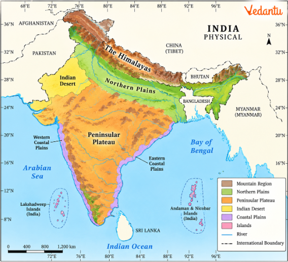
(a) Which major mountain system occupies northern India?
Answer: The Himalayan mountain system extends across northern India.
(b) Which physiographic region lies immediately south of the Himalayas?
Answer: The Northern Plain, formed by the Indus, Ganga, Brahmaputra and their tributaries.
(c) Which plateau occupies a large part of southern India?
Answer: The Peninsular Plateau, including the Deccan Plateau.
(d) Which desert region lies northwest of the Aravalli Hills?
Answer: The Great Indian Desert, also called Marusthali.
(e) Name the two major offshore island groups.
Answer: The Andaman and Nicobar Islands in the Bay of Bengal and Lakshadweep in the Arabian Sea.
(f) Which two mountain ranges form the western and eastern boundaries of the Deccan Plateau?
Answer: The Western Ghats and Eastern Ghats.
Q13. Why is the Tarai region marshy while the Bhabar belt is comparatively dry? Explain their formation and characteristics.
Answer: Bhabar and Tarai are adjoining belts situated near the foothills of the Himalayas.
Explanation: When streams descend from the mountains, they deposit coarse materials along the Bhabar belt. Water seeps into these deposits and later emerges in the Tarai, where it spreads over low-lying ground.
Conclusion: Differences in surface materials and groundwater movement explain the contrasting conditions of the two regions.
Q14. What evidence suggests that the Great Indian Desert experienced different environmental conditions in the distant past?
Answer: The Great Indian Desert is now arid, but geological evidence suggests the sea once covered parts of it.
Wood Fossils at Aakal: Fossilised wood discovered near Jaisalmer indicates that environmental conditions were different in the past.
Marine Deposits Near Brahmsar: Marine deposits support the interpretation of an earlier marine environment.
Mesozoic History: The chapter relates this evidence to the region's geological history during the Mesozoic era.
Present Aridity: Today, rainfall in the desert region described in the chapter is generally below 150 mm annually.
Wind Action: Wind and other physical weathering processes have shaped landforms such as mushroom rocks and dunes.
Limited Drainage: Many streams are seasonal, and some terminate in saline lakes or playas.
Conclusion: Fossils and marine deposits help geographers reconstruct the desert's earlier conditions, while its present landforms reflect an arid environment.
Class 11 Geography Chapter 2 Long Answer Questions
Q15. Explain how the northward movement of the Indian Plate influenced the geological structure and physiography of India.
Answer: The present physical features of India developed over millions of years through plate movements and the action of internal and external forces.
1. Earlier Position of the Indian Plate
Millions of years ago, the Indian Plate was located south of the Equator. It was part of a larger landmass that included the Australian Plate.
2. Separation of Plates
Over geological time, the larger plate system changed. The Australian Plate moved southeastward, while the Indian Plate moved northward.
3. Continued Northward Movement
The Indian Plate continued moving northwards, affecting the subcontinent's geological structure.
4. Formation of the Himalayas
The collision of the Indian Plate with the Eurasian Plate compressed, folded, and uplifted rock layers, helping form the Himalayas.
5. Geological Activity
The Himalayas remain geologically active. Faults, folds, and thrusts show the continuing influence of tectonic forces.
6. Himalayan River Valleys
The young mountain system has steep slopes and fast-flowing rivers that have carved gorges, V-shaped valleys, rapids, and waterfalls.
7. Development of the Northern Plain
As the Himalayas developed, a large depression formed towards the south. Major rivers gradually filled this depression with sediments.
8. Stability of the Peninsular Block
The Peninsular Block consists mainly of ancient, relatively stable rocks. It differs from the young Himalayan system.
9. Faulting in Peninsular India
Although the Peninsular Block is relatively stable, tectonic movements produced features such as the Narmada and Tapi rift valleys.
10. Diversity of India's Relief
These geological processes produced contrasting regions of high mountains, river plains, plateaus, and valleys.
Conclusion: The movement of the Indian Plate explains many important differences between India's geological regions. Together with erosion and deposition, tectonic processes shaped the country's present physiography.
Q16. Explain the major landforms of the Northern Plain. Why are Bhabar, Tarai, Khadar, Bhangar and braided rivers important for understanding this region?
Answer: The Northern Plain formed from sediments deposited by the Indus, Ganga, Brahmaputra, and their tributaries. Different river-flow and deposition conditions created several distinct landforms.
1. Extent of the Northern Plain
The plains extend about 3,200 km east to west and average 150–300 km wide.
2. Bhabar Belt
The Bhabar is a narrow belt of coarse deposits along the Shiwalik foothills. Streams may disappear below its permeable surface.
3. Tarai Region
The Tarai lies south of the Bhabar. Water reappears near the surface, producing marshy conditions and supporting dense vegetation.
4. Bhangar
Bhangar consists of older alluvial deposits. It represents areas formed by earlier phases of river deposition.
5. Khadar
Khadar consists of newer alluvial deposits. Floodwaters often renew these areas by carrying fresh sediment.
6. Meanders
Meanders are bends formed in rivers flowing across relatively gentle slopes. They are common in the mature stages of river development.
7. Oxbow Lakes
When a river cuts off a meander loop, the abandoned channel may form an oxbow lake.
8. Braided Channels
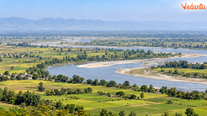
A braided river has several channels separated by sand bars or islands. These develop where river flow and sediment deposition cause channels to divide and rejoin.
9. Brahmaputra Plains
The Brahmaputra is known for shifting channels, riverine islands and sandbars. Periodic floods alter the surrounding landscape.
10. Sundarbans Delta
The Ganga-Brahmaputra river system contributes to the formation of the extensive Sundarbans delta.
11. Fertile Alluvial Soils
River deposits support the cultivation of wheat, rice, sugarcane, jute and other crops.
12. Human Settlement
The combination of broad plains, river water and fertile soil supports large populations.
Important Landforms at a Glance
Conclusion: The Northern Plain is not completely featureless. Its belts and river landforms reveal how erosion, transportation and deposition continuously reshape the region.
Q17. Describe the major subdivisions of the Peninsular Plateau. How do their structure, relief and resources differ?
Answer: The Peninsular Plateau is one of India's oldest and most stable landmasses. It contains ancient rocks, residual hills, dissected plateaus, rift valleys, and mineral-rich regions.
The Peninsular Plateau has three major divisions.
1. Deccan Plateau
The Deccan Plateau covers much of Peninsular India.
The Western Ghats bound it to the west, and the Eastern Ghats to the east.
The Satpura, Maikal, and Mahadeo hills form important features to the north.
The Western Ghats are generally higher and more continuous than the Eastern Ghats.
In Maharashtra, the Western Ghats are also called the Sahyadri.
Important southern mountain areas include the Nilgiri, Anaimalai and Cardamom hills.
According to the chapter, Anaimudi, at 2,695 m, is the highest peak of the Peninsular Plateau.
Many major Peninsular rivers originate in the Western Ghats.
2. Central Highlands
The Central Highlands lie mainly north of the Deccan Plateau.
The Aravalli Range forms an important western boundary.
The region includes the Malwa Plateau and other upland areas.
The Central Highlands generally slope towards the north and northeast.
Tributaries of the Yamuna originate in the Vindhyan and Kaimur ranges.
The Chotanagpur Plateau contains important mineral resources.
The Chambal, Bhind and Morena regions are known for their ravines and gorges.
3. Northeastern Plateau
The Northeastern Plateau extends the main Peninsular Block.
The Meghalaya and Karbi Anglong plateaus form important parts of this region.
A geologically faulted region separates the Meghalaya Plateau from the main Peninsular Block.
The Garo, Khasi and Jaintia Hills are important subdivisions.
Coal, limestone, iron ore and other mineral resources occur in the region.
High rainfall and erosion have influenced the plateau's surface.
Comparison of the Three Plateau Regions
4. Geological Stability
These regions form part of an ancient geological block, although some areas have experienced faulting and upliftment.
5. River Systems
The plateau's structure and slope influence river flow direction and the development of river valleys.
6. Economic Importance
The plateau regions contain varied minerals, soils and landscapes that support different economic activities.
Conclusion: The Peninsular Plateau shares an ancient geological foundation, but its three major regions differ in relief, rainfall, river systems, and mineral resources.
Q18. Why do the Western and Eastern Coastal Plains differ in width, river deltas, harbours and coastal landforms?
Answer: India's western and eastern coastal plains differ because of their geological history, coastal processes, relief and river systems.
1. Western Coastal Plain
The western coastal plain lies between the Western Ghats and the Arabian Sea.
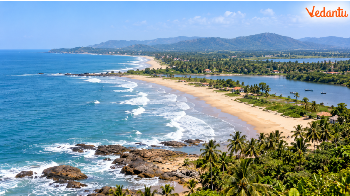
It is an example of a submerged coastal plain.
2. Narrow Coastal Belt
The western coastal plain is generally narrow, particularly in its central portion.
3. Natural Harbours
The submerged character of the western coast provides favourable conditions for several natural harbours.
The chapter mentions Kandla, Marmagao, Mangalore and Cochin among important port locations.
4. Absence of Large Deltas
Many west-flowing rivers are relatively short and descend steeply from the Western Ghats.
They do not generally form the large deltas associated with major east-flowing rivers.
5. Kayals of Kerala
The Malabar Coast contains backwaters known as kayals.
These support fishing, inland navigation and tourism.
6. Eastern Coastal Plain
The eastern coastal plain lies between the Eastern Ghats and the Bay of Bengal.
It is generally broader than the western coastal plain.
7. Emergent Coastal Character
The eastern coastal plain is an emergent coast.
8. Formation of Deltas
Major rivers such as the Mahanadi, Godavari, Krishna and Kaveri deposit sediments before entering the Bay of Bengal.
9. Continental Shelf
The chapter notes that the continental shelf along the eastern coast extends far into the sea in places, influencing harbour conditions.
10. Regional Diversity
The two coasts differ in drainage patterns, coastal landforms and opportunities for maritime activity.
Comparison Between Western and Eastern Coastal Plains
Conclusion: The contrasting landforms of the two coastal plains reflect differences in geological processes, river deposition and the relationship between land and sea.
Q19. Explain the major characteristics of the Great Indian Desert. How do wind action, low rainfall and inland drainage shape the region?
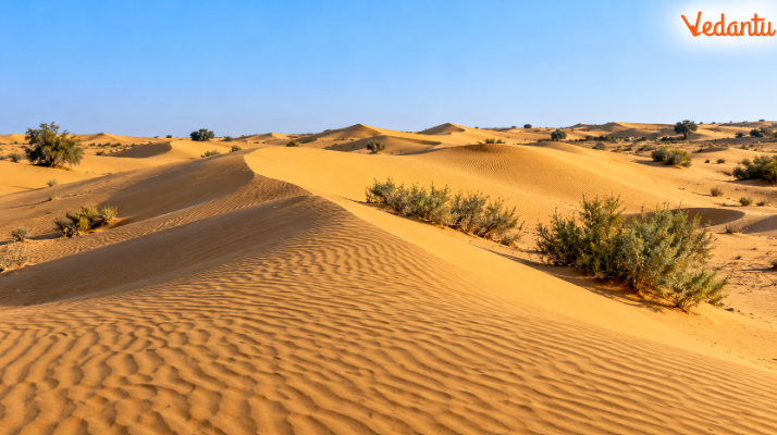
Answer: The Great Indian Desert, also called Marusthali, is located northwest of the Aravalli Hills. Its landforms reflect a dry climate and wind and weathering.
1. Location: The desert occupies a large part of western Rajasthan and adjoining regions.
2. Low Rainfall: Annual rainfall is generally below 150 mm in this region.
3. Arid Climate: Low rainfall and high evaporation produce a severe water deficit.
4. Sparse Vegetation: Limited water availability restricts the growth of natural vegetation.
5. Longitudinal Sand Dunes: These are elongated dunes formed by the movement and accumulation of wind-blown sand.
6. Barchans: Barchans are crescent-shaped dunes formed by wind deposition.
7. Mushroom Rocks: Wind erosion can wear away the lower portions of rocks, producing mushroom-shaped forms.
8. Seasonal Streams: Many desert streams flow only during or shortly after rainfall.
9. Luni River: The Luni is one of the important rivers of the southern desert region.
10. Inland Drainage: Some streams do not reach the sea. Instead, they disappear or drain into inland lakes and playas.
11. Salt Lakes and Playas: High evaporation may leave dissolved salts behind, producing brackish or saline water.
12. Geological Evidence: Wood fossils at Aakal and marine deposits near Brahmsar indicate that the region experienced different environmental conditions in the distant past.
13. Desert Slopes: The chapter describes the northern portion as sloping towards Sindh and the southern portion towards the Rann of Kachchh.
14. Physical Weathering: Repeated heating, cooling and other weathering processes contribute to the breakdown of rocks.
Important Desert Landforms
Conclusion: Low rainfall, high evaporation, wind activity and limited drainage combine to produce the distinctive landforms of the Great Indian Desert.
Q20. Compare the Andaman and Nicobar Islands with Lakshadweep. How do their geological origins, locations and physical features differ?
Answer: India has two major island groups: the Andaman and Nicobar Islands in the Bay of Bengal, and Lakshadweep in the Arabian Sea.
Although both are surrounded by seawater, they differ in geological origin and physical characteristics.
1. Location of the Andaman and Nicobar Islands: The Andaman and Nicobar Islands are located in the Bay of Bengal, southeast of the Indian mainland.
2. Number of Islands: The chapter describes the Bay of Bengal group as containing approximately 572 islands and islets.
3. Geological Origin: Many of these islands are believed to be elevated portions of submarine mountains. Some smaller islands are volcanic.
4. Barren Island: Barren Island is India's only active volcano, as identified in the chapter.
5. Ten Degree Channel: The Ten Degree Channel separates the Andaman group from the Nicobar group.
6. Important Mountain Peaks: The chapter mentions Saddle Peak in North Andaman and Mount Thuiller in Great Nicobar among the island peaks.
7. Climate and Vegetation: The islands experience high moisture conditions and support dense vegetation, with an equatorial character described in the chapter.
8. Location of Lakshadweep: Lakshadweep lies in the Arabian Sea, west of the Kerala coast.
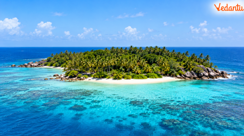
9. Coral Origin: The Lakshadweep islands have been formed from coral deposits.
10. Distance from Mainland India: The chapter places the islands approximately 220–440 km from the Kerala coast.
11. Nine Degree Channel: The Nine Degree Channel is an important water passage associated with the Lakshadweep group.
12. Coastal Features: The islands contain coral-related coastal features and beaches. The textbook also describes storm beaches containing pebbles, cobbles and other loose materials.
Comparison of India's Major Island Groups
13. Impact of Natural Hazards: The Andaman and Nicobar Islands were severely affected by the Indian Ocean tsunami of 26 December 2004.
14. Importance of Geological History: The contrasting island structures show that islands can form through different processes, including tectonic uplift, volcanic activity and coral growth.
Conclusion: The Andaman and Nicobar Islands are mainly associated with submarine mountain-building and volcanic processes, while Lakshadweep consists of coral islands. Their differences provide important examples of India's physical diversity.
Why Practise Class 11 Geography Chapter 2 Important Questions with Vedantu?
Vedantu's Class 11 Geography Chapter 2 Important Questions help students understand how India's mountains, plains, plateaus and other landforms developed. The questions focus on geological processes, physical features, comparisons and map-based practice.
How to Prepare Class 11 Geography Chapter 2 Important Questions?
Understand landform formation: Focus on plate movements, river deposition, faulting and erosion.
Practise comparisons: Revise Bhabar vs Tarai, Bhangar vs Khadar and Western vs Eastern Coastal Plains.
Use chapter maps: Locate the Himalayas, Northern Plain, Peninsular Plateau, desert and islands.
Connect processes with examples: Link wind deposition to barchans, faulting to rift valleys and coral growth to Lakshadweep.
Practise answer writing: Use short points, labelled diagrams and comparison tables where appropriate.
Important Study Material Links for Class 11 Geography Chapter 2
CBSE Class 11 Geography Other Books Important Questions and Study Resources
Chapter-Wise Important Questions for Class 11 Geography - India: Physical Environment
After practising Chapter 2 Structure and Physiography Important Questions, students can continue with the other chapters of India: Physical Environment to understand India's geographical location, drainage patterns, climate, vegetation and natural hazards.
Important Study Materials for Class 11 Geography
FAQs on Important Questions and Answers for Class 11 Geography Chapter 2 - Structure and Physiography (India: Physical Environment) | 2026-27
1. Why is the Peninsular Block more stable than the Himalayan mountain system?
The Peninsular Block consists of ancient rocks and is relatively stable, while the Himalayas are young fold mountains formed by tectonic movements. The Himalayas continue to experience geological activity, whereas the Peninsular Block has undergone comparatively fewer structural changes.
2. What is the difference between geological structure and physiography in Class 11 Geography Chapter 2?
Geological structure refers to the composition, arrangement and history of rocks. Physiography describes physical features such as mountains, plains, plateaus and valleys. Both concepts help students understand how India's landforms developed.
3. Why do rivers disappear in the Bhabar region and reappear in the Tarai?
The Bhabar contains coarse pebbles and boulders, so river water seeps underground. The water reappears farther south in the Tarai, creating marshy and waterlogged conditions.
4. How are Bhangar and Khadar different in the Northern Plain of India?
Bhangar consists of older alluvial deposits, while Khadar contains newer river deposits. Khadar is commonly found in floodplains where rivers deposit fresh sediments during floods.
5. Which Peninsular Plateau divisions are important in Structure and Physiography Class 11 questions and answers?
The three major divisions are the Deccan Plateau, Central Highlands and Northeastern Plateau. Students should understand their locations, relief features, river systems and geological characteristics.
6. Why are the Western Ghats more continuous than the Eastern Ghats?
The Western Ghats form a relatively continuous mountain barrier along the western edge of the Deccan Plateau. The Eastern Ghats are discontinuous because several east-flowing rivers have cut through them.
7. How do wind action and low rainfall shape the Great Indian Desert?
Low rainfall and high evaporation create dry conditions, while winds transport and deposit sand, forming dunes such as barchans. Seasonal streams and inland drainage also influence the desert landscape.
8. Why do Lakshadweep and the Andaman and Nicobar Islands have different geological origins?
Lakshadweep consists of coral islands, while the Andaman and Nicobar Islands are associated mainly with submarine mountain structures. Some islands, including Barren Island, have volcanic origins.
9. What types of questions are included in Class 11 Geography India Physical Environment Chapter 2 Important Questions?
The practice set includes MCQs, very short answers, short answers, long answers and map-based questions. Students practise Himalayan formation, the Northern Plain, Peninsular Plateau, coastal landforms, deserts and island groups through chapter-based explanations.
10. How should students prepare for Class 11 Geography Chapter 2 important questions in exams?
Students should practise geological comparisons, explain how different landforms develop and revise chapter maps. Key areas include Indian Plate movement, the Bhabar and Tarai, Bhangar and Khadar, coastal plains, and island formation. Writing answers in clear points and using comparison tables can make revision easier.