


Important Mountain Passes of Peninsular India with States, Map Details and Exam Notes
Mountain passes in Peninsular India are important geographical features that act as natural gateways through mountain ranges, especially the Western Ghats and Eastern Ghats. These passes have played a significant role in trade, cultural exchange, military movements, and modern transportation. For students preparing for competitive exams, understanding the location, connecting regions, and importance of these mountain passes is essential. This page provides a detailed list of major mountain passes in Peninsular India along with their geographical and economic significance.
What are Mountain Passes?
A mountain pass is a natural gap or route through a mountain range that provides a pathway from one region to another. In Peninsular India, most mountain passes are found in the Western Ghats and Eastern Ghats. These passes help connect the coastal plains with the interior Deccan Plateau and are crucial for road and rail transport.
Major Mountain Ranges in Peninsular India
- Western Ghats - A continuous mountain range running parallel to the western coast of India.
- Eastern Ghats - Discontinuous hills along the eastern coast of India.
- Nilgiri Hills - A part of the Western Ghats located at the junction of Tamil Nadu, Kerala, and Karnataka.
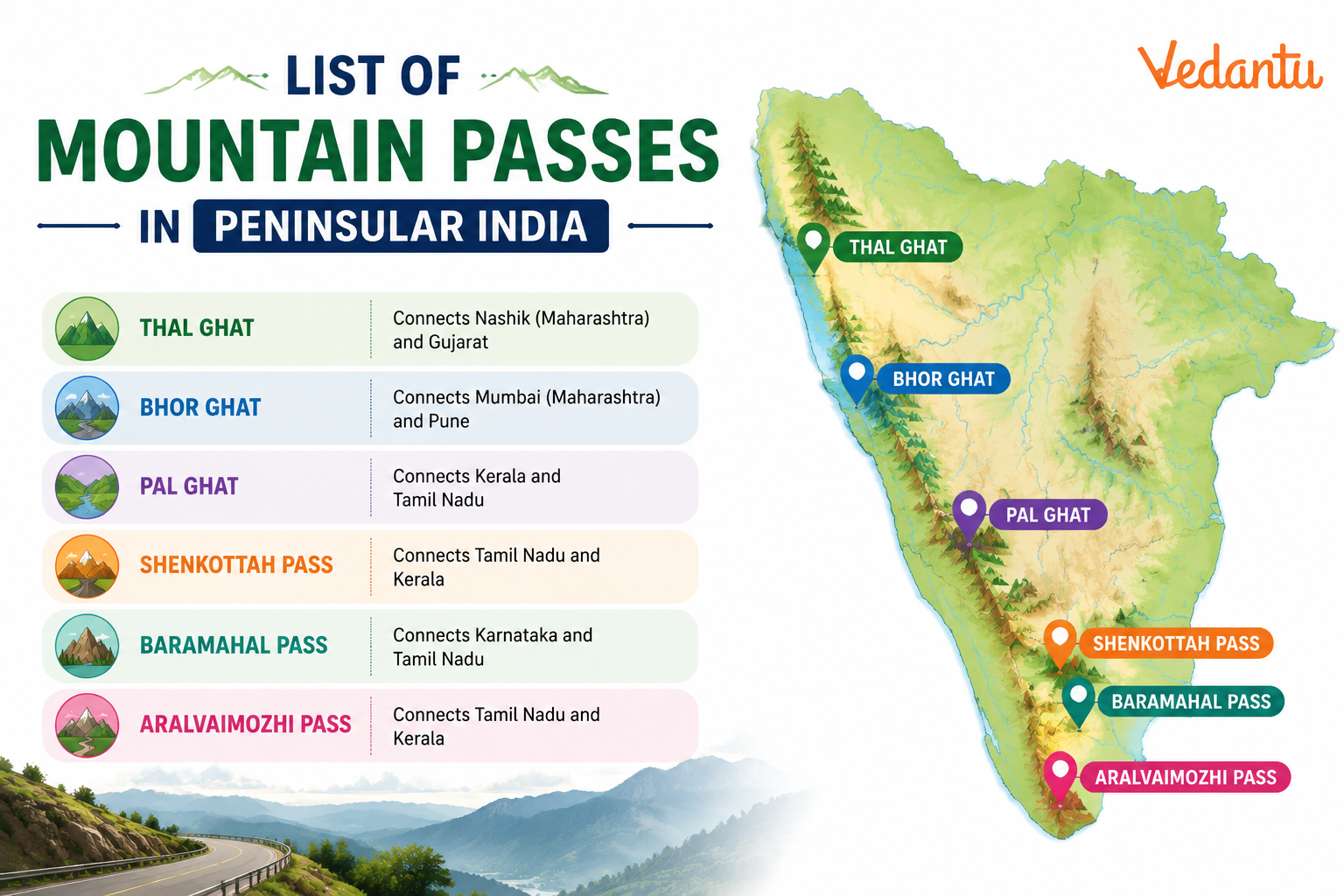
List of Major Mountain Passes in Peninsular India
| Mountain Pass | Location / Range | Connects |
|---|---|---|
| Bhor Ghat | Western Ghats, Maharashtra | Mumbai and Pune |
| Thal Ghat | Western Ghats, Maharashtra | Mumbai and Nashik |
| Palghat Gap | Western Ghats, Kerala - Tamil Nadu | Kerala and Tamil Nadu |
| Shencottah Gap | Western Ghats, Tamil Nadu - Kerala | Tirunelveli and Kollam |
| Charmadi Ghat | Western Ghats, Karnataka | Mangalore and Chikmagalur |
| Agumbe Ghat | Western Ghats, Karnataka | Shivamogga and Udupi |
| Araku Valley Pass | Eastern Ghats, Andhra Pradesh | Visakhapatnam and Araku Valley |
The above mountain passes are strategically important for transportation, tourism, and trade. Many of them now have highways and railway lines passing through them, making them vital for economic development in Peninsular India.
Important Mountain Passes in Detail
Bhor Ghat
Bhor Ghat is located in Maharashtra and connects Mumbai with Pune. It is an important railway and road route across the Western Ghats. Historically, it was used as a trade route between the coastal region and the Deccan Plateau.
Thal Ghat
Thal Ghat, also known as Kasara Ghat, connects Mumbai with Nashik. It is a key rail and road corridor in Maharashtra and plays a major role in freight and passenger transport.
Palghat Gap
Palghat Gap, also called Palakkad Gap, is a wide and low mountain pass in the Western Ghats between Kerala and Tamil Nadu. It allows easy movement of people and goods and influences the climate by allowing the southwest monsoon winds to pass into Tamil Nadu.
Shencottah Gap
Shencottah Gap connects Tamil Nadu and Kerala. It is another important pass in the southern part of the Western Ghats and facilitates trade and transport between the two states.
Charmadi and Agumbe Ghats
Charmadi Ghat and Agumbe Ghat are located in Karnataka. These passes connect the coastal region with the interior parts of the state. Agumbe is also known for receiving heavy rainfall and is often called the Cherrapunji of South India.
Geographical and Economic Importance
- Facilitate transportation between coastal plains and the Deccan Plateau.
- Support trade and commerce by connecting major cities.
- Influence climate patterns, especially in the case of Palghat Gap.
- Promote tourism due to scenic landscapes and biodiversity.
- Provide strategic routes for railways and highways.
Key Points for Competitive Exams
- Most mountain passes in Peninsular India are located in the Western Ghats.
- Palghat Gap is the widest and most significant pass in the Western Ghats.
- Bhor Ghat and Thal Ghat are important for railway connectivity in Maharashtra.
- Mountain passes connect coastal regions with the Deccan Plateau.
- They have both economic and climatic significance.
Conclusion
The mountain passes in Peninsular India are crucial geographical features that have shaped transportation, trade, climate, and regional development. From the busy Bhor and Thal Ghats in Maharashtra to the climatically significant Palghat Gap in Kerala and Tamil Nadu, these passes serve as lifelines connecting different parts of South India. For students and exam aspirants, a clear understanding of their location, connectivity, and importance is essential for mastering Indian geography.
FAQs on List of Major Mountain Passes in Peninsular India with Locations and Key Facts
1. What are the major mountain passes in Peninsular India?
The major mountain passes in Peninsular India are important routes across the Western Ghats and Eastern Ghats that connect coastal plains with the Deccan Plateau.
- Palghat Gap (Kerala–Tamil Nadu)
- Thal Ghat (Maharashtra)
- Bhor Ghat (Maharashtra)
- Shencottah Gap (Tamil Nadu–Kerala)
- Aralvaimozhi Pass (Tamil Nadu)
These mountain passes in South India are crucial for transport, trade, communication, and climate influence.
2. What is the importance of the Palghat Gap?
The Palghat Gap is the widest and most significant mountain pass in the Western Ghats.
- Located between Kerala and Tamil Nadu
- Connects Coimbatore and Palakkad
- Facilitates road and railway transport
- Allows the southwest monsoon winds to enter Tamil Nadu
This pass plays a key role in the climate, trade, and economic activities of Peninsular India.
3. Where is Bhor Ghat located and why is it important?
The Bhor Ghat is an important mountain pass in Maharashtra connecting the coast to the Deccan Plateau.
- Located between Mumbai and Pune
- Lies in the Western Ghats
- Used by the Mumbai–Pune railway and highway
It is historically significant for trade routes and British-era railway construction in Peninsular India.
4. What is Thal Ghat known for?
The Thal Ghat is a key mountain pass in the Western Ghats of Maharashtra.
- Connects Mumbai with Nashik
- Part of the Mumbai–Agra National Highway
- Important for railway and road transport
It serves as a major trade and transport corridor between the Konkan coast and the interior plateau.
5. What is the difference between Western Ghats passes and Himalayan passes?
Mountain passes in the Western Ghats differ from Himalayan passes in terms of height and climate.
- Western Ghats passes are lower in elevation
- They remain open throughout the year
- Himalayan passes are higher and snow-covered
- Himalayan passes often close during winter
Thus, passes in Peninsular India are more accessible and vital for regular transport.
6. Which mountain pass connects Tamil Nadu and Kerala?
The Palghat Gap and Shencottah Gap connect Tamil Nadu and Kerala.
- Palghat Gap: Between Coimbatore and Palakkad
- Shencottah Gap: Near Tirunelveli district
- Facilitate road and rail connectivity
These passes are crucial for inter-state trade, tourism, and monsoon wind movement.
7. Why are mountain passes important in Peninsular India?
Mountain passes in Peninsular India are important for connectivity and economic development.
- Provide natural routes through the Western Ghats
- Support transport and trade
- Enable railway and highway construction
- Influence climate and rainfall distribution
They act as strategic links between the coastal plains and the Deccan Plateau.
8. What is Shencottah Pass?
The Shencottah Pass is a significant gap in the Southern Western Ghats.
- Located between Tamil Nadu and Kerala
- Near Tirunelveli district
- Used for road and railway transport
It plays a vital role in regional connectivity and is often discussed in Indian Geography GK topics.
9. Are there mountain passes in the Eastern Ghats?
Yes, the Eastern Ghats also have mountain passes, though they are less prominent than those in the Western Ghats.
- Eastern Ghats are discontinuous hills
- Passes allow river flow and transport routes
- Important for regional connectivity
However, most well-known passes in Peninsular India are found in the Western Ghats.
10. Which mountain pass is the widest in the Western Ghats?
The Palghat Gap is the widest mountain pass in the Western Ghats.
- Approximately 30–40 km wide
- Located at a lower elevation
- Major route for transport and monsoon winds
It is one of the most frequently asked topics in Geography GK, UPSC, SSC, and State PSC exams.