


Where Is Indira Point Located and Why Is It Important for India?
Indira Point is the southernmost point of India and holds great geographical importance in General Knowledge and competitive examinations. Located in the Andaman and Nicobar Islands, it marks the extreme southern boundary of the Republic of India. Indira Point is situated on Great Nicobar Island and lies close to the international maritime boundary with Indonesia. This point is significant for understanding India’s geographical extent, strategic location, and maritime importance in the Indian Ocean region.
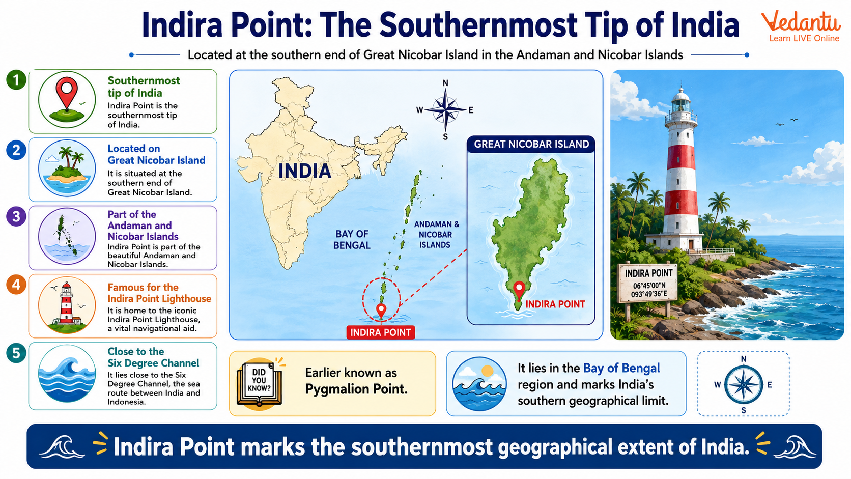
Location of Indira Point
Indira Point is located on the southern tip of Great Nicobar Island, which is the largest island in the Nicobar group. It lies in the Bay of Bengal, near the Andaman Sea, and is part of the Union Territory of Andaman and Nicobar Islands.
- Latitude - Approximately 6 degree 45 minutes North
- Longitude - Approximately 93 degree 49 minutes East
- Island - Great Nicobar Island
- Union Territory - Andaman and Nicobar Islands
- Nearest Country - Indonesia
Historical Background
Indira Point was earlier known as Pygmalion Point during the British period. After the assassination of former Prime Minister Indira Gandhi in 1984, it was renamed Indira Point in her memory. The area gained international attention after the 2004 Indian Ocean tsunami, which caused significant geographical changes in the region.
Impact of the 2004 Tsunami
The 2004 tsunami caused the land around Indira Point to subside by several meters. As a result, parts of the lighthouse and surrounding areas were submerged. The natural disaster highlighted the vulnerability of island regions to seismic activity.
- Land subsidence occurred after the earthquake
- Sea water entered low lying areas
- Lighthouse structure was partially affected
Indira Point Lighthouse
A prominent feature of Indira Point is its lighthouse, which serves as a navigational aid for ships passing through the busy Malacca Strait. The lighthouse plays an important role in ensuring maritime safety in the Indian Ocean region.
- Constructed in 1972
- Helps ships navigating near the Malacca Strait
- Symbol of India’s southernmost boundary
Geographical Significance
Indira Point marks the southern limit of India’s mainland territory and plays a key role in defining India’s latitudinal extent. It is strategically important because of its proximity to major international sea routes. The location enhances India’s maritime presence in the Indian Ocean.
- Southernmost point of India
- Close to the Six Degree Channel
- Strategic location near international shipping lanes
- Important for India’s maritime security
Key Facts About Indira Point
| Feature | Details | Importance |
|---|---|---|
| Location | Great Nicobar Island | Southernmost tip of India |
| Former Name | Pygmalion Point | Renamed in 1984 |
| Lighthouse | Built in 1972 | Maritime navigation |
The above table summarizes the most important facts about Indira Point that are frequently asked in competitive examinations. Students should remember its location, former name, and strategic importance.
Difference Between Southernmost Points
Students often confuse Indira Point with Kanyakumari. It is important to understand the difference between the southernmost point of India and the southernmost point of mainland India.
- Indira Point - Southernmost point of India including islands
- Kanyakumari - Southernmost point of mainland India
Importance in Competitive Exams
Indira Point is an important topic in Geography for exams such as UPSC, SSC, State PSC, NDA, CDS, and other competitive tests. Questions are commonly asked about India’s extreme points, island geography, and strategic maritime locations.
Preparation Tips
- Remember that Indira Point is on Great Nicobar Island
- Do not confuse it with Kanyakumari
- Revise its former name Pygmalion Point
- Understand its strategic location near international sea routes
Conclusion
Indira Point is the southernmost tip of India and an important geographical landmark located on Great Nicobar Island in the Andaman and Nicobar Islands. It has historical, strategic, and maritime significance. From its former name Pygmalion Point to its role after the 2004 tsunami, Indira Point remains a vital topic in Indian Geography. For students and competitive exam aspirants, remembering its location, importance, and key facts is essential for scoring well in General Knowledge sections.
FAQs on Indira Point: The Southernmost Tip of India Explained
1. Where is Indira Point located?
Indira Point is the southernmost tip of India, located in the Andaman and Nicobar Islands in the Bay of Bengal.
- Situated on Great Nicobar Island
- Lies in the Nicobar district
- Close to Indonesia and the Malacca Strait
- Earlier known as Pygmalion Point
This location is often searched as southernmost point of India, last point of India, and Indira Point Nicobar Islands.
2. Why is Indira Point famous?
Indira Point is famous for being the southernmost point of the Republic of India.
- Named after Prime Minister Indira Gandhi
- Important in Indian geography and GK exams
- Affected by the 2004 Indian Ocean tsunami
- Features a historic lighthouse
It is a key topic in General Knowledge, UPSC, SSC, and school geography questions.
3. What was the old name of Indira Point?
The old name of Indira Point was Pygmalion Point during the British period.
- Renamed in 1985
- Honors Indira Gandhi
- Located on Great Nicobar Island
The renaming reflects India’s post-independence identity and is frequently asked in competitive exams.
4. How did the 2004 tsunami affect Indira Point?
The 2004 Indian Ocean tsunami submerged parts of Indira Point and damaged its lighthouse.
- Land sank by about 3–4 meters
- Caused major geographical changes
- Lighthouse area partially underwater
- Severe impact on Great Nicobar Island
This event is important in discussions about natural disasters, tectonic shifts, and coastal geography of India.
5. In which island is Indira Point situated?
Indira Point is situated on Great Nicobar Island, the southernmost island of India.
- Part of Andaman and Nicobar Islands
- Located in the Bay of Bengal
- Administered by the Government of India
This island is known for its strategic importance and biodiversity.
6. Why is Indira Point strategically important?
Indira Point is strategically important due to its location near international sea routes.
- Close to the Malacca Strait
- Important for naval and maritime security
- Monitors shipping routes in the Indian Ocean
- Enhances India’s strategic presence in Southeast Asia
This makes it significant in geopolitics, defense studies, and maritime trade discussions.
7. What is the southernmost point of mainland India?
The southernmost point of mainland India is Kanyakumari, not Indira Point.
- Located in Tamil Nadu
- Meeting point of Arabian Sea, Bay of Bengal, and Indian Ocean
- Indira Point is the southernmost point of India including islands
This distinction is commonly asked in GK and competitive examinations.
8. When was Indira Point renamed?
Indira Point was renamed in 1985 in memory of Prime Minister Indira Gandhi.
- Earlier called Pygmalion Point
- Renamed after her assassination in 1984
- Reflects India’s political history
This fact is important for students preparing for history and polity-based GK questions.
9. Is Indira Point open to tourists?
Indira Point is generally not open for regular tourism due to security and environmental restrictions.
- Located in a restricted tribal area
- Requires special government permission
- Limited infrastructure for visitors
- Protected ecological zone
This makes it different from popular tourist places like Kanyakumari.
10. What is the significance of the Indira Point Lighthouse?
The Indira Point Lighthouse helps in maritime navigation and marks India’s southern boundary.
- Built in 1972
- Guides ships in the Bay of Bengal
- Damaged during the 2004 tsunami
- Symbol of India’s geographical limit
The lighthouse is often mentioned in questions related to Indian geography, coastal landmarks, and navigation systems.