
Rama’s Bridge


An Overview of Rama’s Bridge
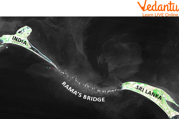
Rama's Bridge is also known as Adam's Bridge or Rama Setu. Rama’s Bridge is a network of natural limestone sandbars located between Pamban Island and Rameswaram Island off the southeastern coast of Tamil Nadu, India, and Mannar Island off the northwestern coast of Sri Lanka. According to geological data, this bridge may have once served as a land link between India and Sri Lanka.
You've probably heard the Ramayana, in which Ravana kidnaps Sita and afterwards Rama constructs Rama Setu (also known as Rama's Bridge) with Hanuman and others to save his wife. In this article, you will learn how this bridge was built, why it was built, and who helped Rama to build a bridge.
Rama’s Bridge
Short Story of Ramayana
Author Valmiki mentions a bridge crossing the ocean to unite India and Sri Lanka in the famous Indian epic Ramayana, which was written thousands of years ago. The nearly 24,000-verse epic poem tells the story of the godly prince Rama and his fight to save his kidnapped wife Sita from the evil king Ravana, who ruled Sri Lanka.
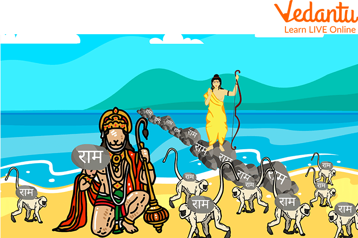
The crown prince Rama was made to give up his claim to the throne and live in isolation for 14 years. Sita, his wife, was kidnapped by the evil demon king Ravana while he was in the forest and carried to Sri Lanka. Rama gathered an army of monkeys and led them to Sri Lanka, where a lengthy war started. Ravana was ultimately defeated, and Rama returned to his house with his wife to be crowned king.
Rama’s Bridge
Ram Setu (Rama’s Bridge) was first mentioned in Valmiki’s Ramayana, a Hindu epic. The bridge is thought to have been constructed by Lord Rama's Vanara Sena on Nala's (who helped Rama to build a Bridge) orders so that Lord Rama could travel to Lanka and rescue his wife Sita. According to legend, the name of Lord Rama was written on the floating rocks, which made the pumice stones unsinkable. The bridge was then used by Rama's army to cross the sea and reach Sri Lanka. This bridge is also known as India Sri Lanka Bridge.
Rama’s Vanara Sena Writing on Stones
Adam’s Bridge separates the Palk Strait (northeast) from the Gulf of Mannar in the southwest and is 48 kilometres (30 miles) long. Navigation is made more difficult because some of the areas are dry and the local seas are rarely deeper than one meter (3 feet). Until storms deepened the waterway in the 15th century, it was supposedly accessible on foot. Records from the Ramanathaswamy Temple claim that Adam's Bridge was above sea level before a cyclone destroyed it in 1480. You may still see a trace of a connecting strip between the two countries if you look at satellite images of this region today.
Summary
In this article, we discussed Rama’s Bridge which has many other names like Adam’s Bridge, India Sri Lanka Bridge, and Rama Setu. In the Hindu epic Ramayana, Nala, a vanara (monkey), is credited as the bridge's engineer. The Rama Setu covers the ocean between Rameswaram (India) and Lanka, which is thought to be Sri Lanka today, allowing lord Rama's army to travel to Lanka. Another name for the bridge is Nala Setu or the bridge of Nala. The construction of the bridge is credited to both Nala and his twin brother Nila and another vanara. Rama Setu bridge connects India and Sri Lanka. We hope you enjoyed reading this article, in case of any doubts feel free to ask in the comments.


FAQs on Rama’s Bridge
1. Why is Rama's Bridge called Adam’s Bridge?
Adam's Peak is a peak in Sri Lanka that is mentioned in certain early Islamic writings (where the biblical Adam supposedly fell to earth). The name Adam's Bridge comes from the texts' descriptions of Adam using the bridge to go between Sri Lanka and India after he was kicked out of the Garden of Eden.
2. Who was the first person to describe Adam’s bridge and when?
Probably the first person to describe it this way was Alberuni (about 1030). The first map of this location with the name Adam's bridge on it was created in 1804 by a British cartographer.
3. Which stone was used to build Rama’s Bridge?
Pumice Stone was used to build Rama’s bridge.
4. What are the dimensions of the bridge?
The width of the bridge varies between 25 and 50 metres and its height above sea level is 25-30 metres. After being submerged almost 50 metres, it rises again on land in Sri Lanka. At its narrowest point, its width is less than 1 km between Sri Lanka and India but becomes 2 to 4 km wide after entering Palk Strait from the Sri Lanka side.
5. Are there any remains of the pillars and walls of Rama Bridge?
There are no remains of stones, pillars, or walls on this bridge. Only a small part between Sri Lanka and India remains as one of the natural rock formations that looks like a rock. The main area (around 22000 square kilometres) in the sea is made of sand-lime stone, which was broken into small pieces. It would be possible to see these pieces at some places on the bridge where it was broken and found on land.
