


List of Coastal Regions of India with Capitals and Coastline Details
India is a peninsular country surrounded by water on three sides, which gives it a long and strategically important coastline. The coastal states of India play a crucial role in trade, fisheries, tourism, climate regulation, and national security. These states lie along the Arabian Sea in the west and the Bay of Bengal in the east. Understanding the coastal states of India is important for school exams, competitive exams like UPSC, SSC, and state PSCs, and for general geographical awareness.
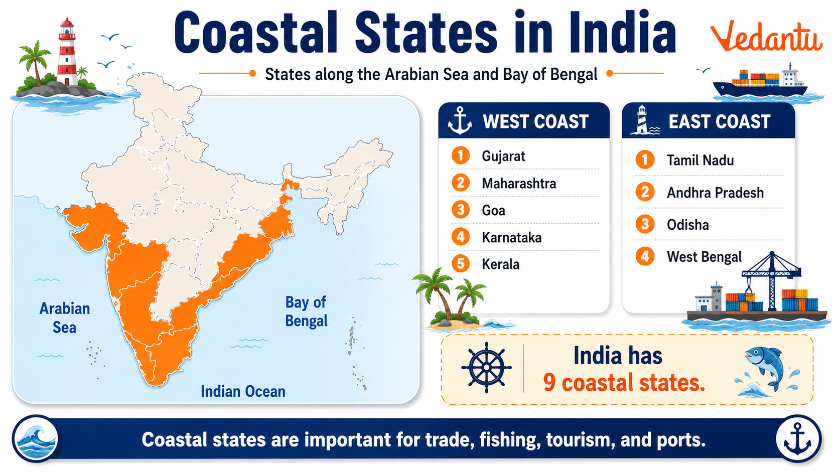
Overview of Coastal States of India
India has a coastline of about 7516.6 km, which includes the mainland coastline and the island territories. Out of the 28 states, 9 states are coastal states. In addition, there are 4 coastal Union Territories. These states and Union Territories have direct access to the sea and are important for maritime trade and economic development.
List of Coastal States of India
| Coastal State | Coastline Along | Capital |
|---|---|---|
| Gujarat | Arabian Sea | Gandhinagar |
| Maharashtra | Arabian Sea | Mumbai |
| Goa | Arabian Sea | Panaji |
| Karnataka | Arabian Sea | Bengaluru |
| Kerala | Arabian Sea | Thiruvananthapuram |
| Tamil Nadu | Bay of Bengal | Chennai |
| Andhra Pradesh | Bay of Bengal | Amaravati |
| Odisha | Bay of Bengal | Bhubaneswar |
| West Bengal | Bay of Bengal | Kolkata |
These nine states together form the mainland coastal belt of India. Gujarat has the longest coastline among all Indian states, while Goa has the shortest coastline among the coastal states.
Coastal Union Territories of India
- Puducherry - Bay of Bengal
- Andaman and Nicobar Islands - Bay of Bengal
- Lakshadweep - Arabian Sea
- Daman and Diu and Dadra and Nagar Haveli - Arabian Sea
These Union Territories are also important for maritime boundaries, tourism, and marine biodiversity. The island territories extend India's presence deep into the Bay of Bengal and Arabian Sea.
Eastern and Western Coastal Plains
Western Coastal Plains
The Western Coastal Plains lie between the Western Ghats and the Arabian Sea. They are narrow and highly indented. Major ports like Mumbai, Kochi, and Mangaluru are located here. This region receives heavy rainfall due to the southwest monsoon.
Eastern Coastal Plains
The Eastern Coastal Plains lie between the Eastern Ghats and the Bay of Bengal. They are wider and more level compared to the western coast. Large river deltas such as the Godavari, Krishna, and Mahanadi are found here. Major ports like Chennai, Visakhapatnam, and Paradip are located along this coast.
Importance of Coastal States
- Facilitate international trade through major and minor ports.
- Support fishing and marine industries.
- Promote tourism through beaches and cultural heritage sites.
- Play a key role in naval defense and maritime security.
- Influence climate and weather patterns of the country.
Major Ports in Coastal States
India has 12 major ports and many minor ports located along its coastline. Some of the important major ports include:
- Kandla Port - Gujarat
- Mumbai Port - Maharashtra
- Mormugao Port - Goa
- New Mangalore Port - Karnataka
- Cochin Port - Kerala
- Chennai Port - Tamil Nadu
- Visakhapatnam Port - Andhra Pradesh
- Paradip Port - Odisha
- Kolkata Port - West Bengal
Geographical and Climatic Features
Coastal states generally experience moderate temperatures due to the influence of the sea. The climate is humid with significant rainfall during the monsoon season. Cyclones frequently affect the eastern coastal states such as Odisha, Andhra Pradesh, and West Bengal. Coastal areas are also rich in mangrove forests, coral reefs, and estuaries.
Key Facts for Competitive Exams
- Total Coastal States - 9
- Longest Coastline - Gujarat
- Shortest Coastline among states - Goa
- Eastern Coast faces the Bay of Bengal.
- Western Coast faces the Arabian Sea.
- India's total coastline length - Approximately 7516.6 km including islands.
Conclusion
The coastal states of India are vital to the country's economy, culture, and strategic strength. From facilitating global trade to supporting marine biodiversity and tourism, these states contribute significantly to national development. A clear understanding of the coastal states, their location, and their features is essential for students preparing for school examinations and competitive exams. Learning these states along with their capitals and coastline details helps build a strong foundation in Indian geography.
FAQs on Coastal States in India: Complete Guide for Students
1. What are the coastal states of India?
India has nine coastal states that share a boundary with the Arabian Sea or the Bay of Bengal.
These coastal states of India are:
• Gujarat
• Maharashtra
• Goa
• Karnataka
• Kerala
• Tamil Nadu
• Andhra Pradesh
• Odisha
• West Bengal
These states lie along the Arabian Sea (west coast) and the Bay of Bengal (east coast), making them important for trade, ports, fisheries, and tourism.
2. How many coastal states are there in India in 2026?
As of 2026, India has nine coastal states.
In addition to these states, India also has two coastal Union Territories:
• Puducherry
• Andaman and Nicobar Islands
This is an important GK fact for competitive exams, UPSC, SSC, and school exams.
3. Which is the longest coastal state in India?
Gujarat has the longest coastline among all coastal states of India.
Key facts:
• Coastline length: About 1,600 km
• Located along the Arabian Sea
• Important ports: Kandla Port, Mundra Port
Gujarat plays a major role in maritime trade, shipping, and industrial development.
4. Which coastal state is known as the ‘Spice Garden of India’?
Kerala is known as the ‘Spice Garden of India’ due to its rich production of spices.
Important details:
• Located on the south-west coast
• Major spices: pepper, cardamom, cloves
• Famous for backwaters and Arabian Sea coastline
Kerala’s coastal climate supports agriculture, tourism, and fishing industries.
5. Which coastal state lies on the eastern coast of India?
The eastern coastal states of India lie along the Bay of Bengal.
These states include:
• West Bengal
• Odisha
• Andhra Pradesh
• Tamil Nadu
The eastern coast is also called the Coromandel Coast (Tamil Nadu) and Northern Circars (Andhra region).
6. Which coastal state has the largest port in India?
Maharashtra is home to Mumbai Port, one of the largest and busiest ports in India.
Key highlights:
• Located on the Arabian Sea
• Major ports: Mumbai Port, Jawaharlal Nehru Port (JNPT)
• Important for international trade and shipping
Maharashtra plays a key role in India’s maritime economy.
7. Why are coastal states important for India’s economy?
Coastal states are crucial for trade, fisheries, tourism, and maritime transport.
Main reasons:
• Development of major and minor ports
• Growth of fishing industry and seafood exports
• Boost to tourism (beaches, water sports)
• Support for import-export trade
India’s long coastline of about 7,516 km strengthens its global trade connections.
8. What is the difference between the eastern and western coastal plains of India?
The western and eastern coastal plains differ in width, rivers, and geographical features.
Western Coastal Plains:
• Narrow and uneven
• Between Western Ghats and Arabian Sea
Eastern Coastal Plains:
• Wider and flatter
• Formed by river deltas like Godavari, Krishna, Kaveri
This topic is important in Geography GK and school syllabus.
9. Which coastal state is famous for the Sundarbans Delta?
West Bengal is famous for the Sundarbans Delta, the largest mangrove forest in the world.
Key facts:
• Located in the Bay of Bengal
• Home to the Royal Bengal Tiger
• Formed by rivers like Ganga, Brahmaputra, and Meghna
The Sundarbans is a UNESCO World Heritage Site and an important GK topic.
10. Which is the smallest coastal state in India?
Goa is the smallest coastal state of India by area.
Important points:
• Located on the western coast
• Bordered by the Arabian Sea
• Famous for beaches, tourism, and Portuguese heritage
Despite its small size, Goa is a major tourist destination and an important coastal region.