Isogonic lines of a magnetic map represent lines joining places with the same.
A. ${B_H}$
B. dip
C. zero dip
D. declination
Answer
582.9k+ views
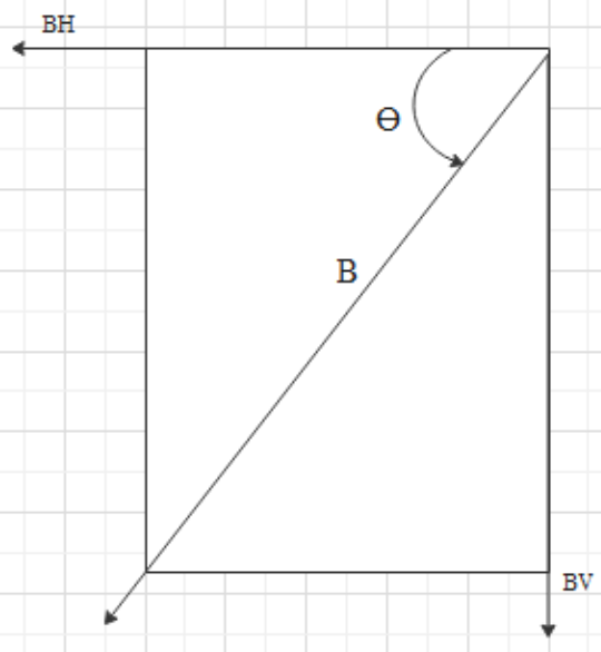
Hint: According to modern earth’s magnetism theory, Earth has both geographic poles and magnetic poles. These poles of the earth’s magnet produce magnetic fields surrounding the earth. Just like the magnetic field produced around a permanent magnet has different magnetic intensities at different points, the total magnetic intensity at different locations of the earth also varies from place to place. Total magnetic intensity (B) has two components. One is the vertical component $({B_V})$ and the other is the horizontal component $({B_H})$.
Complete step-by-step solution
The angle between the resultant total magnetic field(B) vector at a particular location and its horizontal component $({B_H})$ vector is called a dip at a particular location.

Here the angle theta is the dip.
Now the plane which is passing through geographic poles at a certain place is called geographic meridian and the plane which is passing through magnetic poles at a certain place is called the magnetic meridian and the angle between these two planes is called the declination at that place. Declination varies from place to place.
The dip angle lies in the magnetic meridian. Whereas declination is the angle between the two planes.
Isogonic lines of the magnetic map represent the lines joining the places with the same declination
So the answer would be option D.
Note: There are different terms for the lines which join the places that have the same dip and same ${B_H}$. Isoclinic lines represent the lines, which join the places having the same dip while isodynamic lines join the places which have the same horizontal magnetic component of earth. Dip angle will be ninety degrees at magnetic poles whereas zero at the equator.
Complete step-by-step solution
The angle between the resultant total magnetic field(B) vector at a particular location and its horizontal component $({B_H})$ vector is called a dip at a particular location.

Here the angle theta is the dip.
Now the plane which is passing through geographic poles at a certain place is called geographic meridian and the plane which is passing through magnetic poles at a certain place is called the magnetic meridian and the angle between these two planes is called the declination at that place. Declination varies from place to place.
The dip angle lies in the magnetic meridian. Whereas declination is the angle between the two planes.
Isogonic lines of the magnetic map represent the lines joining the places with the same declination
So the answer would be option D.
Note: There are different terms for the lines which join the places that have the same dip and same ${B_H}$. Isoclinic lines represent the lines, which join the places having the same dip while isodynamic lines join the places which have the same horizontal magnetic component of earth. Dip angle will be ninety degrees at magnetic poles whereas zero at the equator.
Recently Updated Pages
Master Class 12 Economics: Engaging Questions & Answers for Success

Master Class 12 Physics: Engaging Questions & Answers for Success

Master Class 12 English: Engaging Questions & Answers for Success

Master Class 12 Social Science: Engaging Questions & Answers for Success

Master Class 12 Maths: Engaging Questions & Answers for Success

Master Class 12 Business Studies: Engaging Questions & Answers for Success

Trending doubts
Which are the Top 10 Largest Countries of the World?

What are the major means of transport Explain each class 12 social science CBSE

Draw a labelled sketch of the human eye class 12 physics CBSE

What is a transformer Explain the principle construction class 12 physics CBSE

Why cannot DNA pass through cell membranes class 12 biology CBSE

Differentiate between insitu conservation and exsitu class 12 biology CBSE


