


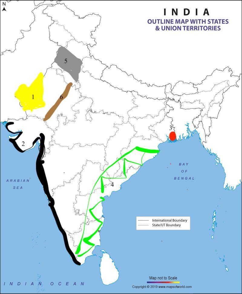
Mark and name the following on the outline map of India . Give a proper index. ( Any four)
1. Thar desert
2. Western Coastal Plains
3. Sunderbans
4. Eastern ghats
5. Punjab Haryana Plain
6. Aravalli hills
Answer
581.7k+ views
Hint: We can locate different locations on a map. For example, Thar desert is situated in Rajasthan . Sunderbans is situated in West Bengal. Eastern and western coastal regions mark the west and the east part of India. All these can be plotted on a map easily.
Complete answer:
1. Thar desert : Thar Desert, additionally called Great Indian Desert, arid district of sand slopes on the Indian subcontinent. It is found halfway in Rajasthan state, northwestern India, and mostly in Punjab and Sindh (Sind) territories, eastern Pakistan.
2. Western coastal plains: The Western Ghats Coastal Plain starts from Surat to Kanyakumari which is divided into four parts:The Gujarat Plain-Coastal territory of Gujarat; The Konkan Plain-Between Daman and Goa;The Kannad Plain-Between Goa and Mangalore; The Malabar Plain-Between Mangalore and Kanyakumari.
3.Sunderbans: The Sundarbans is a mangrove territory in the delta framed by the intersection of the Ganges, Brahmaputra and Meghna Rivers in the Bay of Bengal.
4. Eastern Ghats: The Eastern Ghats are important mountain bodies reaching out from Central India to the far south and running parallel toward the east coast.
5. Punjab Haryana plain :The Punjab-Haryana Plains owe their source to the Satluj, the Beas and the Ravi streams. They reach out from The northern part of the district, adjoining the Siwaliks.
6. Aravalli Hills : Aravali Range is an old hill system of northern India, runs northeasterly for 350 miles (560 km) through Rajasthan state.
Thus , the correct markings are given below.
Note: Maps are an important instrument of locating geographical areas. It is important to know the correct locations to mark the specific regions. The location of the place in respect to the state must be taken into consideration in order to avoid geographical similarities.
Recently Updated Pages
Master Class 12 Business Studies: Engaging Questions & Answers for Success
Master Class 12 Biology: Engaging Questions & Answers for Success
Master Class 12 Chemistry: Engaging Questions & Answers for Success
Class 12 Question and Answer - Your Ultimate Solutions Guide
Master Class 11 Social Science: Engaging Questions & Answers for Success
Master Class 11 English: Engaging Questions & Answers for Success
Trending doubts
What is BLO What is the full form of BLO class 8 social science CBSE
Citizens of India can vote at the age of A 18 years class 8 social science CBSE
Right to vote is a AFundamental Right BFundamental class 8 social science CBSE
10 slogans on organ donation class 8 english CBSE
Name the states through which the Tropic of Cancer class 8 social science CBSE
Explain land use pattern in India and why has the land class 8 social science CBSE