


Types of Map Symbols and How They Make Map Reading Easy
Reading maps using symbols is an essential part of the map. It provides a lot of information in a limited space. Map symbols are easy to draw and read even if you can't ask someone for directions because you don't know the local language. You may use symbols to collect information from maps.
What are Symbols?
A symbol is a shape or object used to represent something else. Symbols are often used to refer to different things in different situations. Different symbols and colors are used on maps to mark important places such as hospitals, train stations, and schools.
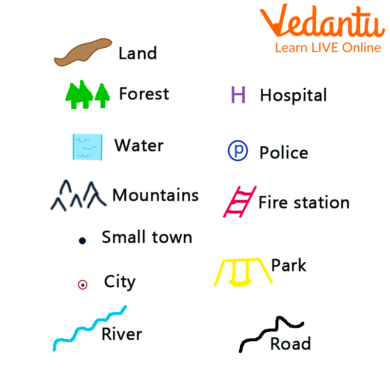
Symbols Used on a Map
What are Maps?
A map is a pictorial representation of all or part of an area, usually displayed on a flat surface. A map is an image that provides information about a place. For example, a map of bedrooms might show where beds, dressing tables, and wardrobes are located. A map of a city or region shows streets, highways, schools, or places of interest.
Maps are very useful and important to us. They help us navigate different places and give us directions to different places with the help of directions symbols present on the maps.
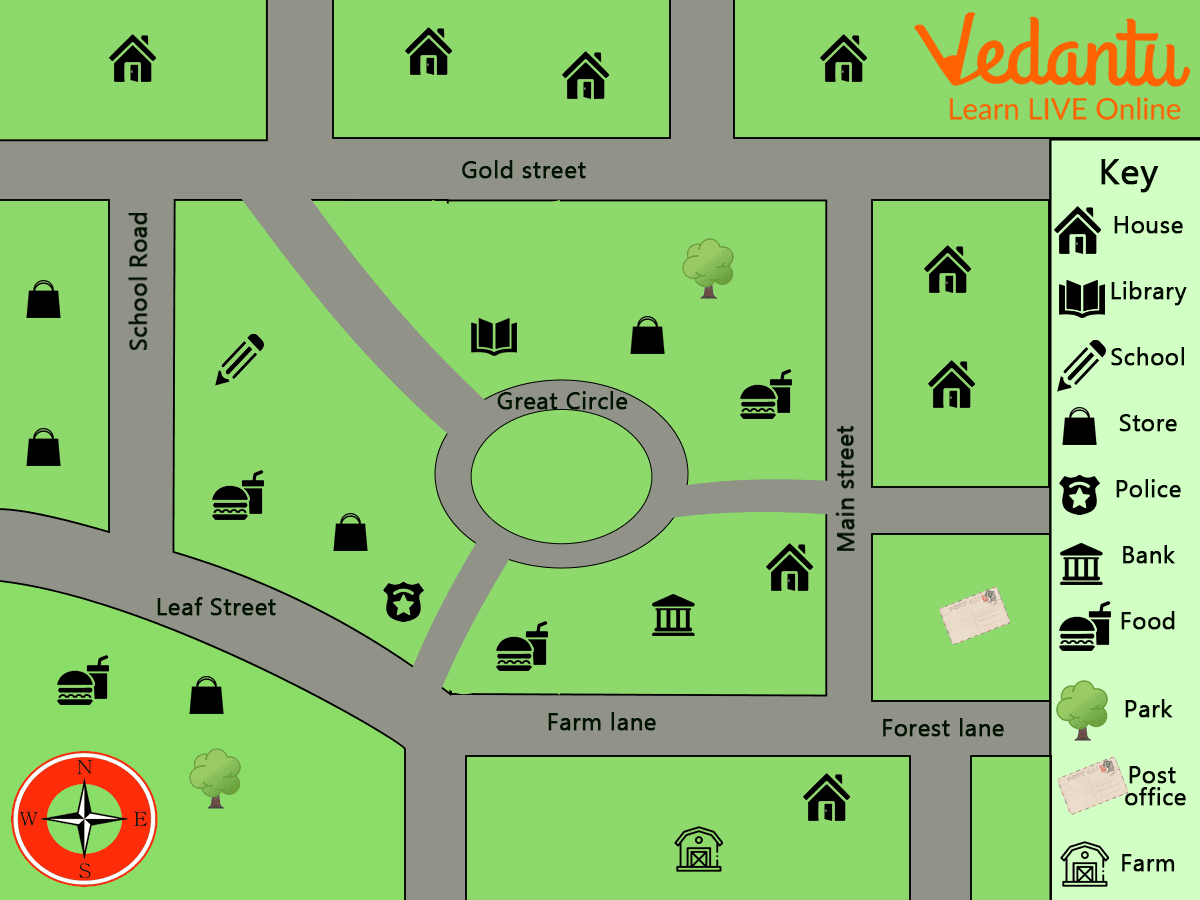
Map of a Community
Map Reading
Reading a map is the process of looking at a map to see what is being displayed and how the cartographer(a person who draws or makes maps) described the map. This includes identifying the objects or phenomena depicted, the symbols and labels used, and information about the map that may not appear on the map.
Map Reading
How do Symbols Help in Reading Maps?
Maps are easy to draw with symbols and are easy to understand without asking anyone for directions as we don't know the language of the area. Symbols are made up of individual points, lines, or shaded areas on the map. They have size, shape, and (usually) color. Map symbols collectively represent details that lead to shape, relative location, distribution, and structure.
The best way to read a map or directions is to use symbols. You can use symbols such as lines, shapes, shades, or colors to easily find specific landmarks or directions. Buildings, roads, rivers, bridges, trees, railroads, and many other elements make it impossible to draw a map in real shape and size. So we use specific symbols, shades, colors, images, etc. to display the map line. This symbol provides a lot of information and helps to read the card.
Summary
We have learnt about maps, their types, the symbols used on a map and how these symbols can help us to find directions. Map reading is an exercise which can help us in many ways. When you grow up and learn to drive, this reading will help you locate many places across the world. You can practice what you learnt till now with the help of a worksheet given at the end of this article.
Map Symbols Worksheet
Use Maps and answer the questions
1. Answer the following using the given maps.
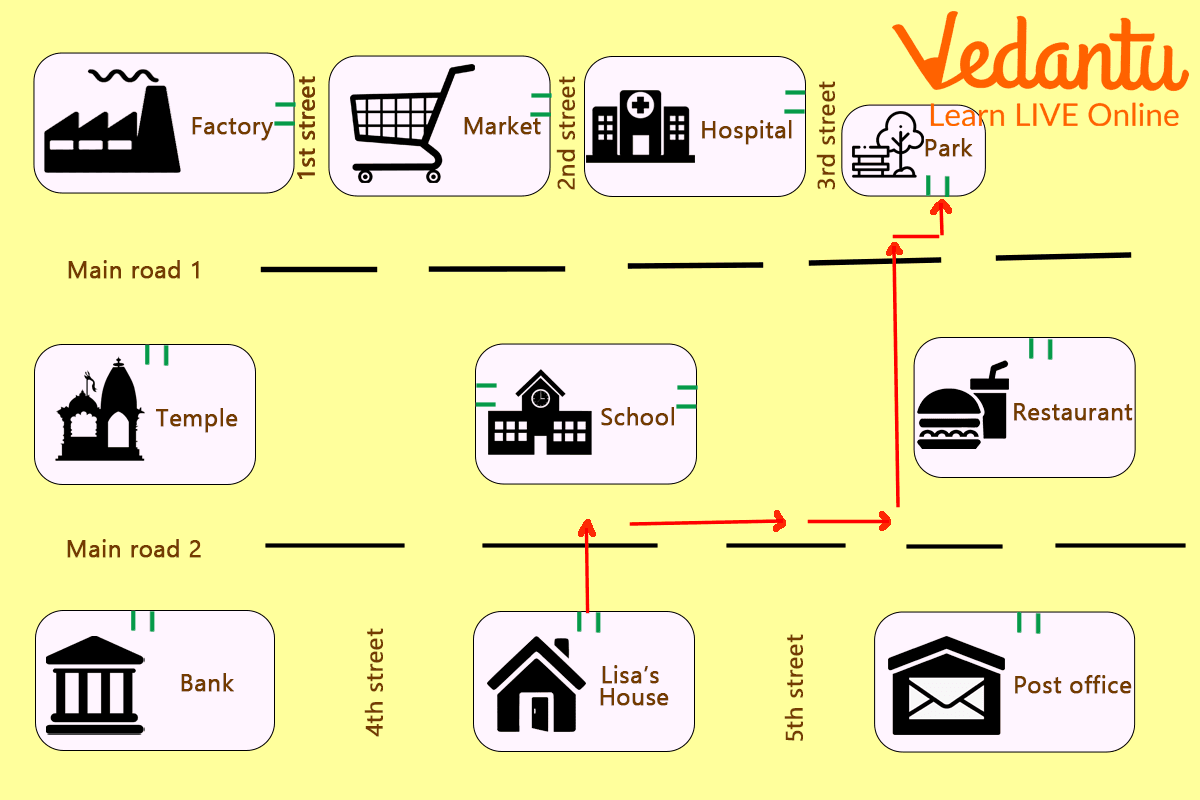
Directions on a Map
(i) In which direction a hospital is situated?
(ii) What is situated between 1st and 2nd street?
(iii) How to reach the restaurant from main road 2?
(iv) By what symbol hospital is represented?
Answers:
(i) Hospital situated right to 2nd street.
(ii) Market lies between 1st and 2nd street.
(iii) More straight on main road 2 then reaching in front of 3rd street turn right to reach the restaurant.
(iv) Hospital is represented by a plus(+) symbol.
FAQs on Understanding How Map Symbols Help in Reading a Map
1. What are symbols on a map?
Map symbols are small pictures, lines, or shapes used to represent real-world features on a map. Because it is impossible to draw everything exactly to scale, symbols are used to show:
- Points (e.g., schools, hospitals, railway stations)
- Lines (e.g., roads, rivers, boundaries)
- Areas (e.g., forests, lakes, parks)
2. How do symbols help in reading a map?
Map symbols help in reading a map by showing important information clearly and quickly without using long descriptions. They:
- Make the map less crowded
- Help identify places instantly
- Allow easy comparison of distances and locations
- Make large areas understandable at a small scale
3. Why are conventional symbols important in maps?
Conventional symbols are important because they are standard symbols used worldwide and are understood by everyone. These symbols:
- Have fixed meanings
- Are accepted internationally
- Help maintain uniformity in map reading
4. What is the difference between physical and political map symbols?
The main difference is that physical map symbols show natural features, while political map symbols show human-made boundaries and settlements.
- Physical symbols: mountains, rivers, forests
- Political symbols: cities, states, countries, capitals
5. What is a map key or legend?
A map key or legend is a box or section that explains the meaning of map symbols. It helps the reader understand what each symbol represents. For example:
- A small airplane symbol = Airport
- A tree symbol = Forest
6. How do symbols relate to map scale in Maths?
Map symbols work with map scale to represent large real-world objects in smaller sizes accurately. For example, if the scale is 1 cm = 1 km, a 5 cm road on the map represents 5 km in reality. Symbols simplify objects while the scale ensures correct measurement of distances.
7. How can you calculate real distance using map symbols and scale?
You can calculate real distance by multiplying the map distance by the scale factor. Steps:
- Measure the distance on the map (e.g., 4 cm).
- Check the scale (e.g., 1 cm = 2 km).
- Multiply: 4 × 2 = 8 km.
8. Why can’t maps show real pictures instead of symbols?
Maps cannot show real pictures because they are drawn to a reduced scale and would become overcrowded. Since maps represent large areas in small sizes, symbols are used to:
- Save space
- Maintain clarity
- Ensure easy measurement and calculation
9. What are point, line, and area symbols in maps?
Point, line, and area symbols are three main types of map symbols used to represent different features.
- Point symbols: Show specific locations (e.g., hospital).
- Line symbols: Show linear features (e.g., roads, rivers).
- Area symbols: Show regions (e.g., lakes, forests).
10. How do map symbols help students in Maths exams?
Map symbols help students by making it easier to interpret data, measure distances, and solve scale-based problems. In Maths exams, students may need to:
- Use the scale to calculate real distance
- Identify locations using symbols
- Compare areas or routes