


Download Free PDF with Solutions of Climate Class 10, Chapter 4
Exercise:
1. Write the names of the States/Regions in appropriate columns:
Bihar, Tocantins, Pernambuco, Alagoas, Eastern Maharastra, Western part of Rajasthan, Gujarat, Rio Grande Do Norte, Paraiba, Western Ghats, Eastern Himalayas, Western Andhra Pradesh, Roroima, Amazonas, West Bengal, Roraima, Rio Grande do Sul, Santa Catarina, Goa
Ans:
2. State whether right or wrong. Rewrite the wrong sentences
The fact that Brazil lies on the equator affects its climate in a big way.
India and Brazil have the same seasons at the same time.
India faces tropical cyclones frequently.
Brazil gets a lot of rainfall because of the southwest monsoon winds.
Ans:
The given statement is right.
The given statement is wrong - Different seasons are in effect simultaneously in Brazil and India.
The given statement is right
The given statement is wrong - The South-East and North-East Trade Winds bring rain to Brazil.
Give Geographical Reasons:
1. The northeastern part of the Brazilian Highlands receives very less rainfall.
Ans:
Rainfall in Brazil is caused by the South-East and North-East Trade Winds.
The Brazilian Highlands in some places go all the way to the northern coast.
The escarpments block the winds coming from the sea, which results in the rain in the coastal zone.
These winds have less of an impact outside of the Highlands.
There is less rainfall in the northeastern region of the Brazilian highlands. The "Drought Quadrilateral" is another name for this area of a rain shadow.
2. Snowfall doesn’t always occur in Brazil.
Ans:
Brazil experiences a wide range of climate changes due to its huge latitudinal length.
It is heated close to the Equator, while the Tropic of Capricorn has a tropical environment.
When it comes to Brazil's temperatures, the northern section of the country is hot while the southern part is noticeably cooler.
Areas located in polar or temperate climates, as well as hilly terrain at extremely high altitudes, typically see snowfall.
Snowfall does occur, however it is only found in the southern states of Rio Grande Do Sul, Parana, and Santa Catarina at higher elevations.
The majority of the nation is located in a tropical region, which has a hot and humid temperature. Therefore, snowfall is a rare phenomenon in Brazil and does not constantly happen.
3. Conventional type of rainfall is not prominent in India.
Ans: The equator crosses Brazil's northern area, and convectional showers are a characteristic of equatorial locations.
The air here expands and rises upward as a result of the extreme heat. The air cools down as it ascends, causing condensation to happen and clouds to form. Convectional rains result from this every day.
Convection rainfall is not common in India because such conditions don't exist there.
4. Tropical cyclones occur rarely in Brazil.
Ans:
There are seldom any temperature changes in Brazil's coastal districts close to the equator.
In this tropical region, the winds blow vertically.
The trade wind convergence zone is also weak in this area. Therefore, cyclones do not develop because tropical cyclones rarely hit Brazil.
5. There is not much difference in the range of temperature in Manaus.
Ans: Manaus is near the equator and situated in northern Brazil.
The sun's perpendicular rays reach this area all year round.
It also gets convectional rain every day.
As a result, the climate is hot and humid all year long. Thus, there is not much difference in the range of temperature in Manaus.
6. India receives precipitation from the North-East Monsoon winds too.
Ans:
The North East Monsoon Winds have an impact on India during the winter.
The country enjoys a cool breeze thanks to these winds.
The North East Monsoon Winds take up moisture as they pass across the Bay of Bengal and bring rain to India's eastern coasts of Andhra Pradesh and Tamil Nadu.
The North East Monsoon winds are also known to bring precipitation to India.
Answer The Following Questions:
1. Describe in brief the changes occurring in the climatic conditions of India while going from south to north.
Ans: India has a monsoon-style climate. However, due to the latitudinal location and altitude of the region, India has a variety of climates.
The subtropical and tropical regions of India are separated by the Tropic of Cancer, which runs through the heart of the country.
The tropical zone receives nearly vertical Sunrays, and as we approach the south, the temperature rises.
The subtropical region in the north experiences extremely hot summers and very chilly, dry winters.
The Himalayas are located in India's northern region. They shield us from the chilly winds and block the southwest monsoon winds, which cause rainfall on the southern slopes.
Rainfall predominates in the majority of India, whilst snowfall predominates in the Himalayas.
2. Explain the importance of the Himalayas and the Indian Ocean with respect to the climate of India.
Ans: The climate of India and the beginning of the monsoons are significantly influenced by the Indian Ocean and the Himalayan mountain ranges.
The Punjab Plains and Rajasthan's Thar Desert have low-pressure systems because of the hot summers.
A high-pressure area forms over the Indian Ocean at the same time.
Winds are drawn to this, and they begin to blow from the Indian Ocean toward the Indian subcontinent.
These winds carry moisture, bringing rain to India.
As these winds approach the Himalayas, rain develops as a result of the Himalayas' inherent blockage.
Later, as these winds move away from the Himalayas and into the Indian Ocean from the northeast, they bring rain to some areas of the Peninsula.
The Himalayas also block the cold winds that come from the north, protecting India from harsh winters.
3. Discuss the factors affecting the climate of Brazil.
Ans:
Brazil's extensive latitudinal range, proximity to the equator, presence of the Atlantic Ocean, and the Great Escarpment all contribute to its wide range of climatic changes.
While the climate near the Tropic of Capricorn is temperate, it is scorching in the northern region of Brazil near the Equator.
The South-East and North-East Trade Winds, which originate from the Atlantic Ocean, bring rain to Brazil.
Areas close to the equator experience convectional precipitation. The Escarpment, on the other hand, acts as a barrier to the winds coming from the sea and produces rain in the coastal zone.
The impact of these winds is lessened outside of the Highlands, which results in less precipitation. It is known as "The Drought Quadrilateral" and is a rain-shadow zone.
Since the Equator runs through this region of Brazil's north, the temperature is high. 25° to 28°C is the typical temperature in the Amazon Valley. Highlands have colder temperatures. While they are considerably lower in the southern region.
Temperature variations are minimal in Brazil's coastal districts close to the equator. The coast has a moderate and humid environment due to its proximity to the sea.
In this area, the wind patterns are vertical. The trade wind convergence zone is also ineffective at this location. Tropical cyclones are hence a rare occurrence here.
4. Compare the climates of Brazil and India.
Ans: The comparison of the climates of Brazil and India is given below:
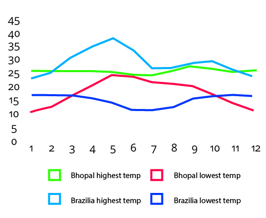
5. With the help of the internet, obtain information regarding the annual average temperatures of the continental location of Brasilia and Bhopal and explain it with the help of a graph.
Ans: Information about Brasilia: Tropical climate is what Brasilia has. In Brasilia, the summers are significantly more rainy than the winters.
Precipitation Information: Annual precipitation amounts to about 1668 mm.
June has the least amount of precipitation, with an average of 7 mm. The wettest month is January when there is an average of 284 mm of precipitation.
Temperature Information: The typical yearly temperature in Brasilia is 21.1 °C. The hottest month of the year is September, with an average temperature of 22.3 °C. June has the lowest annual average temperature, hovering at about 18.9 °C.
The difference in precipitation between the wettest and driest months is 277 mm. The average annual temperature variation is 3.4 °C.
Information about Bhopal: Tropical weather prevails here. Here, the winters rarely see any precipitation but the summers frequently do. Here, the average temperature is 25.1 °C. Annual precipitation totals are around 1132 mm.
Precipitation Information: With only 2 mm of rain, April is the driest month. The month of August receives the most precipitation, averaging 359 mm.
Temperature Information: The warmest month of the year is May. May's average temperature is 33.6 °C. The coldest month is January, with an average temperature of 18.2 °C.
Find Out
1. Cherrapunji and Mawsynram receive more than 11000 mm of rainfall. Shillong located very near to these places receives only 1000 mm of rainfall. What could be the reason?
Ans: Cherrapunji and Mawsynram receive more rainfall as compared to Shillong because they are on the windward side of the hills and Shillong lies on the leeward side.
It is common in Shillong to see thunderstorms on the horizon at night but have no rain the next day.
Give it a Try.
1. Considering the location, and extent of Brazil and India, look for the differences in the elements of climate like temperature and rainfall as per direction. Write a short note on it.
Ans: The climatic conditions of both the countries- India and Brazil are influenced by their coastline. Generally, India experiences a tropical and subtropical climate, because the Tropic of Cancer passes through the center of India.
Also, India receives rainfall from Southwest monsoon winds and on the other hand, Brazil gets its rainfall from Southeast and Northeast trade winds.
Northern Brazil has a hot and humid climate and Southern Brazil experiences a temperate climate.
2. Considering the various factors affecting Brazil’s climate, complete the adjoining table.
Ans:
3. In which part of India are three crops grown in a year? How is this related to the rainfall over there?
Ans: Usually in many states like Assam, West Bengal, Odisha, etc, three crops are grown in a year. And also in the coastal areas of Tamil Nadu, rice is grown three times a year. The North East Monsoon winds pick up the moisture and give rain to the eastern coast of Tamil Nadu.
Can you Tell?
Study the graphs given in fig. 4.4 and answer the following questions.
In which month is the highest temperature found in all four cities?
In which month does it rain the most in the given cities?
When does Brazil have its rainy season?
Which city has the maximum range of temperature? How much is it?
What type of climate will be found in Rio De Janeiro?
Ans:
The highest temperature in all four cities Manaus, Belem, Porto Alegre, and Rio de Janeiro is found in the months of August-October, June-December, January-February, and February respectively.
It rains the most in the cities of Manaus, Belem, Porto Alegre, and Rio de Janeiro in the months, March, August-September, and January-February respectively.
December to April are the months in which Brazil has its rainy season.
Porto Alegre is a city that has a maximum range of temperature of about 30 to 150 degrees Fahrenheit.
Tropical Savannah is the type of climate which is found in Rio De Janeiro.
India:
Observe Fig 4.3 and write the answers.
Which region gets more than 4000 mm of rainfall?
Identify the regions with maximum and minimum temperature.
In which direction is the temperature increasing?
Identify the direction of the winds shown. What are they known as?
Which winds are responsible for the rainfall in India?
Some part of Rajasthan is in the desert. What could be the reason for it?
Draw the main parallel of latitude passing through India which affects its climate.
In which part of Peninsular India are semi-arid climatic conditions found and why?
Ans:
The Western coasts of India, Western Ghats, Cherrapunji, and Arunachal Pradesh are the regions that get more than 4000 mm of rainfall.
The regions with maximum and minimum temperatures are the east side beside Bengal and Rajasthan respectively.
The temperature is increasing in the West North direction.
The wind direction is shown from where it originates from.
The Monsoon winds are responsible for the rainfall in India which are from the Bay of Bengal and the Arabian Sea.
Some part of Rajasthan is under desert because the temperature is very high in summers and also because the Aravallis lie parallel to the path of the Arabian Sea.
Do it yourself.
Karnataka and the district of Bellary are parts of Peninsular India with semi-arid climatic conditions.
Intext
1. What difference do you find between the rainy seasons of Chennai and other cities of India?
Ans: Chennai mainly receives rainfall in winter which is from October to December whereas other cities mostly receive rainfall from June to September.
2. What similarity do you see in the temperature curves of Delhi and Kolkata?
Ans: The similarity seen in the temperature curves of Delhi and Kolkata is that they both have extreme temperatures.
3. Calculate the average range of minimum and maximum temperatures of all four cities.
Ans: The average range of minimum and maximum temperatures of all the four cities are as follows:
Chennai -
Maximum- 24.41
Minimum - 33.1
Mumbai-
Maximum - 22.16
Minimum - 31.83
Kolkata -
Maximum - 21.08
Minimum - 32.1
Delhi-
Maximum - 16.08
Minimum - 31.3
4. In which city is the range minimum? What can you infer from this?
Ans: The range is minimum in Delhi. It can be inferred that the climate of Delhi overlaps between the monsoon humid subtropics and the semi-arid with high variation.
5. In which city is the range maximum? What can you infer from this about its climate?
Ans: The range is maximum in Chennai. It can be inferred that Chennai has a tropical wet and dry climate and also that the city lies on the thermal equator and is on the coast.
6. Based on the temperature and rainfall of Mumbai, comment upon its climate.
Ans: Based on the temperature and rainfall of Mumbai it can be said that the climate of Mumbai is a Tropical wet and dry climate. Also, Mumbai’s climate is moderately hot with a high level of humidity.
7. Classify the cities as cities with equable and extreme climates.
Ans:
Cities with equable climates- Mumbai and Chennai.
Cities with extreme climates - Kolkata and Delhi
Importance of Maharashtra Board textbook solutions for Class 10 Geography Climate
The Class 10 Geography Chapter 4 Climate is a crucial chapter included in the syllabus for Maharashtra Board students. The chapter provides information about all the different forms of quadratic equations and how they can be represented. The chapter also talks about the different methods of solving quadratic equations, such as the Factorization Method, the method of completing the square, and the Quadratic Formula. Students will learn about different concepts such as Nature of Roots, Factor Theorem, and Rolle’s Theorem in the chapter.
1. Access to solutions by experts: Getting guidance and learning from experts who have curated the answers that focus on learning standards specific to the age group. It also provides well explained and easy to understand solutions for a student.
2. Beneficial for resolving doubts: Sometimes, questions asked in the chapter become challenging to comprehend, especially for students who find Geography difficult. The textbook solutions can present them with elaborative and comprehensive answers or solutions which will benefit them in case of doubts.
3. Learning through mistakes: When a student is trying to solve a question, it is often observed that they get the correct answers but do not follow the proper method. In such cases, textbook solutions can help them understand the experts' approach, which they can use while finding the answers.
4. Practice with the right approach: Practicing the questions by following correct methods and techniques becomes significant for a student. These practice questions become the building blocks for their further question-solving practice. Hence, it is crucial to solving many questions based on a concept with the right approach.
Benefits of using Vedantus' PDF Solutions for Class 10 Geography Maharashtra Board
No doubt, Climate is one of the toughest chapters. But the concepts have been cleared with the solutions provided by Vedantu experts. They have explained each and every single process and concept in a very easy language.
Practising from the Class 10 Geography Chapter 4 will help students in building a great foundation for the chapter. The chapter Climate is a very important chapter in the syllabus, and students will get all the help in preparing for their exams.
If students have missed out to take notes during their classes, they can easily download the PDF version of the chapter solutions from Vedantu. One can easily access the file, and they can be viewed offline from any mobile device as well.
Students can use the solutions to revisit any doubts that they have about the chapter and their answers. This can be an aid during the revision for examinations.
Practice Well With Maharashtra Board Class 10 Geography Chapter 4 Solutions
Download Maharashtra board class 10 geography solutions chapter 4 climate and begin practising right now. There are a lot of concepts and formulas that you have to keep in mind for completing the chapter. Hence, early preparation will help you improve your understanding of the chapter. Download the PDF version of these solutions from Vedantu today.


