


Which physiographic division is shown in the given map?
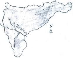
a.Peninsular plateau region
b.Indian plains
c.Highland region
d.Coastal plain region
Answer
566.7k+ views
Hint: The triangular Peninsular Plateau lies in the Northern Plains and extends till Kanyakumari, the southern tip of India. The Western Ghats and the Eastern Ghats lie to the west and east of the Peninsular Plateau, respectively.
Complete Step by Step Answer:
a)-The physiographic division shown in the map is of the peninsular plateau region. This plateau is one of the oldest surfaces of the Earth and exemplifies a segregated part of the old Gondwana land.
The Peninsular Plateau is made up of igneous and metamorphic rocks and are a part of the tectonic plate called the Gondwanaland.
-This is bordered by the Satpura, Maikal range and Mahadeo hills in the north.
-Anaimudi is the highest peak of the Peninsular plateau region.
-Most of the peninsular rivers flow west to east implying it’s general slope, except Narmada and Tapi.
b) The Indian plains are also known as the Indo-Gangetic Plain. The region is named after the Indus and the Ganges rivers and comprises a number of large urban areas. This option is incorrect.
c) The Central Highland region of India is a biogeographic region in India formed by the Satpura ranges and Vindhya Hills. It lies to the north of the Narmada river covering a major area of Malwa plateau. This option is incorrect.
d) Coastal plains are areas of low relief bounded seaward by the shore and landward by highlands. This option is incorrect.
Hence, the correct option is 'a'. The rest of the other options stand irrelevant.
Note:
-According to the 2011 census, the population density in this area is 200 to 500 persons per sq km except Chhattisgarh.
-The Damodar valley in this region has rich coal deposits. -Textile is an important industry in Malwa region.

Recently Updated Pages
Master Class 11 Computer Science: Engaging Questions & Answers for Success
Master Class 11 Business Studies: Engaging Questions & Answers for Success
Master Class 11 Economics: Engaging Questions & Answers for Success
Master Class 11 English: Engaging Questions & Answers for Success
Master Class 11 Maths: Engaging Questions & Answers for Success
Master Class 11 Biology: Engaging Questions & Answers for Success
Trending doubts
What are the factors of 100 class 7 maths CBSE
The value of 6 more than 7 is A 1 B 1 C 13 D 13 class 7 maths CBSE
Convert 200 Million dollars in rupees class 7 maths CBSE
AIM To prepare stained temporary mount of onion peel class 7 biology CBSE
Write a letter to the editor of the national daily class 7 english CBSE
List of coprime numbers from 1 to 100 class 7 maths CBSE