


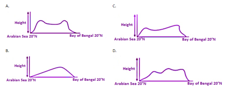
Which of the following diagrams shows the approximate relief of India around 20° N, from Daman to Bhubaneswar?
Answer
506.7k+ views
Hint: The disparity between a location's highest and lowest elevations is known as relief in geography. The local relief or the topography of a given region can be depicted on a two-dimensional relief map, like the ones given in the options. Raised areas on physical relief maps correspond to various elevations on actual land.
Complete answer:
Relief is depicted on flat maps in a number of ways. On older flat maps, areas with varying thickness lines to reflect differences in the steepness of locations can be seen. The thicker the lines in this technique, known as "hachuring," the steeper the field. Hachuring was replaced by shaded areas that reflected changes in the land's steepness as mapmaking progressed. These are the charts we're talking about.
These maps can also provide altitude notations at different points on the map to provide meaning to viewers.
Let us analzye the givn options:
Option A) On either side of India, the Western and Eastern Ghats can be found. Since the average elevation of the Western Ghats is 900-1600 meters and that of the Eastern Ghats is 600 meters. Graph A correctly reflects the relief of the Western and Eastern Ghats.
Option B) Graph B shows a slope increasing from Arabian sea, which is incorrect because we know the Western Ghats are located near the Arabian sea.
Option C) and Option D) Graph C and D depict a more or less plateau or a highland kind of a relief all the way from the West to the East which is incorrect. This is because, Western and Eastern Ghats are much higher than the Deccan highlands.
Thus, the correct answer is Option (A)
Note: On flat charts, differences in elevation can be depicted by different colors—usually lighter to darker for ascending elevations, with the darkest areas being the highest above sea level. The disadvantage of this approach is that land contours are not visible.
Recently Updated Pages
Master Class 8 Social Science: Engaging Questions & Answers for Success
Master Class 8 English: Engaging Questions & Answers for Success
Class 8 Question and Answer - Your Ultimate Solutions Guide
Master Class 8 Maths: Engaging Questions & Answers for Success
Master Class 8 Science: Engaging Questions & Answers for Success
Master Class 9 General Knowledge: Engaging Questions & Answers for Success
Trending doubts
What is BLO What is the full form of BLO class 8 social science CBSE
Citizens of India can vote at the age of A 18 years class 8 social science CBSE
Full form of STD, ISD and PCO
Advantages and disadvantages of science
Right to vote is a AFundamental Right BFundamental class 8 social science CBSE
What are the 12 elements of nature class 8 chemistry CBSE