


How do you know where the most gentle slope is?
Answer
609.9k+ views
Hint: The slope of a land is depicted on the maps and topographical sheets by the distance between the contour lines on the map.
Complete answer:
The slop on a map is determined by the contour interval which is basically the distance between the contour lines on the map. By analysing the contour lines, a fair idea of the slope of the land of the region under analysis can be made. This is a very easy technique to determine if the land is hilly, plateau shaped or a plain area.
If the contour lines are very close enough, it is a representation of a steep slope or a steeply sloped mountain.
If the contour lines are fairly close enough, it is a representation of a normal slope or an average hill.
If the contour lines are far enough, it is a representation of a gentle slope.
So, by looking only at the spacing of the contour lines, one can tell if a slope is gentle, normal or steep. Hence, the most gentle slope is the region on the map where the contour lines are found at the largest distance.
A depiction of the contour interval on the map is given below for the reference of the students.
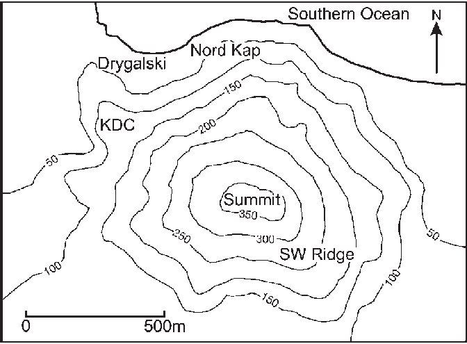
Note: The contours are the line on a map or a topographical sheet which connect the places of the same elevation form the mean sea level on the map. They are the most important tools for survey purposes and a geographer relies the most on the contouring methods.
Complete answer:
The slop on a map is determined by the contour interval which is basically the distance between the contour lines on the map. By analysing the contour lines, a fair idea of the slope of the land of the region under analysis can be made. This is a very easy technique to determine if the land is hilly, plateau shaped or a plain area.
If the contour lines are very close enough, it is a representation of a steep slope or a steeply sloped mountain.
If the contour lines are fairly close enough, it is a representation of a normal slope or an average hill.
If the contour lines are far enough, it is a representation of a gentle slope.
So, by looking only at the spacing of the contour lines, one can tell if a slope is gentle, normal or steep. Hence, the most gentle slope is the region on the map where the contour lines are found at the largest distance.
A depiction of the contour interval on the map is given below for the reference of the students.
Note: The contours are the line on a map or a topographical sheet which connect the places of the same elevation form the mean sea level on the map. They are the most important tools for survey purposes and a geographer relies the most on the contouring methods.
Recently Updated Pages
Basicity of sulphurous acid and sulphuric acid are
Master Class 12 Economics: Engaging Questions & Answers for Success
Master Class 12 Biology: Engaging Questions & Answers for Success
Master Class 11 English: Engaging Questions & Answers for Success
Master Class 11 Physics: Engaging Questions & Answers for Success
Master Class 11 Computer Science: Engaging Questions & Answers for Success
Trending doubts
Difference Between Plant Cell and Animal Cell
Fill the blanks with the suitable prepositions 1 The class 9 english CBSE
What is pollution? How many types of pollution? Define it
What is the full form of pH?
What is the Full Form of ICSE, CBSE and SSC
Name 10 Living and Non living things class 9 biology CBSE