


What does the conventional symbol at grid reference 145132 mean?
Answer
585.3k+ views
Hint: It is an exact point on a map with a rise recorded alongside it that speaks to its stature over a given datum. Not at all like a seat mark, which is set apart by a circle or plate, there is no official sign of spot tallness on the ground albeit, in the open nation, spot statutes may once in a while be set apart by cairns.
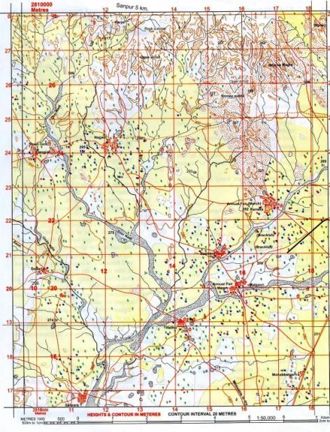
Complete step-by-step solutionA map is an emblematic portrayal of accentuating connections between components of some space, for example, articles, locales, or topics. Numerous maps are static, fixed to paper, or some other sturdy medium, while others are dynamic or intelligent. Albeit most usually used to portray geology, maps may speak to any space, genuine or anecdotal, regardless of setting or scale, for example, in cerebrum planning, DNA planning, or PC network geography planning. The space being planned might be two dimensional, for example, the outside of the earth, three dimensional, for example, the inside of the earth, or considerably more theoretical spaces of any measurement, emerge in displaying marvels having numerous free factors. Numerous maps are attracted to a scale communicated as a proportion, for example, $1:10000$, which implies that 1 unit of estimation on the map relates to 10,000 of that equivalent unit on the ground. The scale explanation can be exact when the area planned is little enough for the arch of the Earth to be disregarded, for example, a city map. Planning bigger locales, where bend can't be overlooked, expects projections to plan from the bent surface of the Earth to the plane. A spot stature is an accurate point on a map with a rise recorded alongside it that speaks to its tallness over a given datum. It is known as Ordnance Datum in the UK. Dissimilar to a seat mark, which is set apart by a circle or plate, there is no official sign of spot tallness on the ground albeit, in the open nation, spot statutes may now and again be set apart by cairns. In geoscience, it tends to be utilized for demonstrating rises on a map, close by forms, seat marks, and so on.
Thus, the correct answer is spot height- 270.
Note Graticules are the numbers at the edges of the guide that gives the directions for each line (latitude or longitude).
Recently Updated Pages
Master Class 12 Social Science: Engaging Questions & Answers for Success
Master Class 12 Physics: Engaging Questions & Answers for Success
Master Class 12 Maths: Engaging Questions & Answers for Success
Master Class 12 Economics: Engaging Questions & Answers for Success
Master Class 12 Chemistry: Engaging Questions & Answers for Success
Master Class 12 Business Studies: Engaging Questions & Answers for Success
Trending doubts
Which are the Top 10 Largest Countries of the World?
Draw a labelled sketch of the human eye class 12 physics CBSE
Explain the structure of megasporangium class 12 biology CBSE
What are the major means of transport Explain each class 12 social science CBSE
How many chromosomes are found in human ovum a 46 b class 12 biology CBSE
The diagram of the section of a maize grain is given class 12 biology CBSE