


What is the globe?
Answer
616.5k+ views
Hint: It is a tool used to depict the Earth and facilitate studies of geography, the topography and climate of the Earth.
Complete answer:
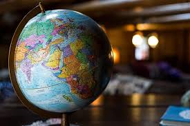
a. A globe is a spherical figure which is a miniature form of earth. It gives us a three-dimensional view of the whole Earth by showing distances, directions, areas, etc.
b. Globes are available in a variety of sizes and types, like the terrestrial globe and the celestial globe. It is not fixed, it can rotate, just like the earth rotates on its axis and this is because a needle is fixed through it to give a more realistic view. The points at the top and bottom of the globe, through which the needle runs are the two poles i.e., the North Pole and the South Pole.
c. The globe provides 3-D (three-dimensional view) of the entire Earth. The latitudes and longitudes are shown on the globe as circles or semi-circles.
Note: The earliest terrestrial globe which is a type of globe, was constructed in 1492 by Martin Behaim with help of a painter called Georg Glockendon. Behaim was a German mapmaker and navigator, he lived in Nuremberg, Germany, he called his globe the "Nürnberg Terrestrial Globe’’, It is now popularly known as the Erdapfel.
Complete answer:
a. A globe is a spherical figure which is a miniature form of earth. It gives us a three-dimensional view of the whole Earth by showing distances, directions, areas, etc.
b. Globes are available in a variety of sizes and types, like the terrestrial globe and the celestial globe. It is not fixed, it can rotate, just like the earth rotates on its axis and this is because a needle is fixed through it to give a more realistic view. The points at the top and bottom of the globe, through which the needle runs are the two poles i.e., the North Pole and the South Pole.
c. The globe provides 3-D (three-dimensional view) of the entire Earth. The latitudes and longitudes are shown on the globe as circles or semi-circles.
Note: The earliest terrestrial globe which is a type of globe, was constructed in 1492 by Martin Behaim with help of a painter called Georg Glockendon. Behaim was a German mapmaker and navigator, he lived in Nuremberg, Germany, he called his globe the "Nürnberg Terrestrial Globe’’, It is now popularly known as the Erdapfel.

Recently Updated Pages
Basicity of sulphurous acid and sulphuric acid are
Master Class 12 Economics: Engaging Questions & Answers for Success
Master Class 12 Biology: Engaging Questions & Answers for Success
Master Class 11 English: Engaging Questions & Answers for Success
Master Class 11 Physics: Engaging Questions & Answers for Success
Master Class 11 Computer Science: Engaging Questions & Answers for Success
Trending doubts
Give 10 examples for herbs , shrubs , climbers , creepers
What is the opposite gender of Gander class 6 english CBSE
What is the Total Duration of Football Match?
What is BLO What is the full form of BLO class 8 social science CBSE
Explain the Treaty of Vienna of 1815 class 10 social science CBSE
Draw a labelled sketch of the human eye class 12 physics CBSE